- Charmouth
-
Coordinates: 50°43′59″N 2°54′00″W / 50.733°N 2.900°W
Charmouth 
Charmouth Beach looking toward Golden Cap
 Charmouth
Charmouth shown within DorsetPopulation 1,687 District West Dorset Shire county Dorset Region South West Country England Sovereign state United Kingdom Post town BRIDPORT Postcode district DT6 Dialling code 01297 Police Dorset Fire Dorset Ambulance South Western EU Parliament South West England UK Parliament West Dorset Website http://www.charmouth.com/ Charmouth Parish Council List of places: UK • England • Dorset Charmouth is a village at the mouth of the River Char in West Dorset, England, with a population of 1,687 according to the 2001 census.[1]
Contents
The village
Charmouth overlooks Lyme Bay. In the eighteenth and nineteenth centuries it was a noted resort, whose visitors included novelist Jane Austen.[2] The village is larger now, but still appears placid, nestled at the base of steep hills along the River Char. Stonebarrow Hill is on the east, Black Venn on the west, and Golden Cap, 2.5 miles (4.0 km) to the east, rises to 617 feet (188 m). The National Trust controls significant portions of the scenic areas around the town.
The Queens Arms, a famous building in the village, was built for an abbot. Catherine of Aragon used it as her residence in 1501. It later became an inn, one of whose temporary boarders (1651) was King Charles II, who arrived in disguise after his defeat at the Battle of Worcester.
Geology
The cliffs above the beach are a noted source of fossils from the Jurassic period. Charmouth Heritage Coast Centre acts as a visitor centre for the Jurassic Coast, a World Heritage Site, and identifies fossils found in the area. Fossil-hunters walk the beaches between Lyme Regis and Charmouth but have to be wary of tides and landslips.
The Jurassic Coast, 153 km long, extends from Orcombe Point near Exmouth in the west, to Old Harry Rocks on the Isle of Purbeck, in the east.[3] The coastal exposures along the coastline provide a continuous sequence of Triassic, Jurassic and Cretaceous rock formations spanning approximately 185 million years of the Earth's history. The localities along the Jurassic Coast includes a large range of important fossil zones.
See also: List of places on the Jurassic CoastHistory
The history of Charmouth dates back to the Iron Age when a Celtic tribe, the Durotriges, founded a settlement. Evidence of hill forts can still be seen in the area. The name Charmouth originated from the Saxon 'Cerne' meaning stony river, Charmouth was therefore known as 'Cernmunde'.[4]
Historian George Roberts wrote:[5]
During the Saxon period, the neighbouring coast was particularly subject to the invasions of the Danes, concerning whom so much has been written. In 787, the Danes, Northern men, or Normans, landed at Portland from three ships, to reconnoitre the country, which they did without interruption, as the Saxons had neglected their marine. A. D. 833, according to the Saxon Chronicle, though some of our historians place the event in 831 or 832, a dreadful battle was fought at Charmouth. The Danes having met with repulses in other parts of the kingdom sailed to Charmouth where having landed, Speed says, "they made cruel ravage and slaughter." Their fleet consisted of 35 ships, containing a powerful army: their whole force, Huntingdon remarks, must have amounted to 17,500 men; other writers have estimated their numbers at about 15,000. Egbert collected the whole force of the county, and marched to attack them, after they had continued their ravages, according to Matthew of Westminster, about a twelve month. The king had nearly succeeded in cutting them off as they were forming; he threw them into great confusion, but continual supplies of men from the ships turned the scale in their favour. The Saxons were routed: the night alone prevented their destruction by the infuriated invaders, by the favour of which, Speed says, the king hardly escaped. Among the number of the slain were two earls, his principal officers, Dudda and Osmond, Wigen, bishop of Sherborne, and Hereferth, bishop of Winton. The Danes, finding a settlement would be liable to the attacks of the brave Egbert, retired to their ships with precipitation, and set sail. They continued to hover about the coast. In 840, they effected a landing on the same spot, (set Carrum,) from the same number of ships. Ethelwulf's army, which he headed in person, advanced to encounter them: a bloody battle ensued, which, after a desperate struggle, terminated in the Danes remaining masters of the field, though they shortly afterwards retired without any spoil. A successive series of invasions followed.
The buildings running either side of Charmouth's street vary in age, some of the smaller cottages are 17th and 18th century whilst those going up the hill are built in Regency style. A number of buildings in the village have listed building status.[6] The Queens Armes Hotel, which is a grade II listed building, looks like a Georgian built house, but is actually an early 16th century house that was re-faced in the 18th century.[7] It once belonged to Forde Abbey and the badge of Catherine of Aragon was found worked into the plaster of an upstairs room.[8] Later, after the house became an inn, it gave shelter to the fugitive King Charles II on 22 September 1651, when he came disguised looking for a boat to take him to France following his defeat at the Battle of Worcester. A small trading ship was found bound for St Malo. The master, Stephen Limbry, agreed to pick up the King from Charmouth beach and transport him to the ship, but just two hours before the pick up Limbry told his wife, who locked him in his room and stole his clothes to ensure he would not become involved.[9] On the following day Charles left Charmouth pursued by troops, who were alerted to his presence by an employee of the inn.[10]
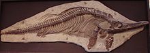 Ichthyosaur fossil from Charmouth
Shops
There are shops on the coast to serve locals and tourists, including the Fossil shop, and cafe.
See also
References
- ^ "Charmouth 2001 census parish profile". Dorset County Council. http://www.dorsetforyou.com/index.jsp?articleid=325346.
- ^ Austen wrote that Charmouth was "a nice place for sitting in unwearied contemplation".
- ^ "Dorset and East Devon Coast". UNESCO World Heritage Centre. 2001. http://whc.unesco.org/pg.cfm?cid=31&id_site=1029.
- ^ The History and Antiquities of the Borough of Lyme Regis and Charmouth George Roberts, 1834
- ^ Roberts, p. 11
- ^ "Map of listed buildings in Charmouth". West Dorset District Council. http://webapps.westdorset-dc.gov.uk/Mapping/Pages/MapMain.aspx?Theme=Listed+Buildings&Easting=346579&Northing=92940&Settlement=Bridport&Zoom=800.
- ^ "Detailed Record: IoE Number 104714". Images of England. English Heritage. http://www.imagesofengland.org.uk/details/default.aspx?id=104714.
- ^ Whaley, Peta (2002). West Country History: Dorset. Intellect Books. ISBN 978-1-84150-803-0. http://books.google.com/books?id=esmaHUdnXPAC&pg=PA49&dq=queen%27s+arms+charmouth#v=onepage&q=queen's%20arms%20charmouth&f=false.
- ^ Roberts, p. 115
- ^ Newman, P. R. (1985). Atlas of the English Civil War. Taylor & Francis. p. 109. ISBN 978-0-7099-1811-0. http://books.google.com/books?id=z3QOAAAAQAAJ&pg=PA109&dq=queen%27s+arms+charmouth#v=onepage&q=queen's%20arms%20charmouth&f=false.
Bibliography
- Roberts, George (1834). The History and Antiquities of the Borough of Lyme Regis and Charmouth. S. Bagster and W. Pickering. http://books.google.com/books?id=T_kVAAAAYAAJ&pg=PA1&dq=The+History+and+Antiquities+of+the+Borough+of+Lyme+Regis+and+Charmouth#v=onepage&q=&f=false.
External links
Categories:- Villages in Dorset
- Beaches of Dorset
- Populated coastal places in Dorset
- Jurassic Coast


Wikimedia Foundation. 2010.