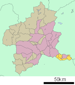
- Ōra District, Gunma
-
List of provinces of Japan > Tōsandō > Kōzuke Province > Ōra District
Japan > Gunma Prefecture > Ōra District
Ōra District (邑楽郡 Ōra-gun) is a district located in Gunma(Kōzuke Province).
As of May, 2008, the district has an estimated Population of 107,157 and a Density of 810 persons/km². The total area is 132.32 km².
The district contains 5 towns.
All towns have been growing in the industrial business but not in the tourism.
Timeline
- April 1, 1889 - Due to the municipal status enforcement, the town of Tatebayashi and 21 villages were formed.(1 town, 21 villages)
- July 25, 1902 - The village of Koizumi gained town status to become the town of Koizumi.(2 towns, 20 villages)
- 1916 - Population: 83,319. Malaria Patients: 3,609.
- April 1, 1954 - The town of Tatebayashi and the villages of Satoya, Ōshima, Akabane, Rokugō, Minoya, Tatara, and Watarase merged to form the city of Tatebayashi.(1 town, 13 villages)
- February 1, 1955 - The villages of Nishiyada, Ebise, Ōgano, and Inara merged to form the town of Itakura.(2 towns, 9 villages)
- March 1, 1955(2 towns, 6 villages)
- The villages of Takashima and Nakano merged to form the village of Nakashima.
- The villages of Chieda, Umeshima, and Sanuki merged to form the village of Meiwa.
- March 31, 1955 - The villages of Tominaga, Eiraku, and Nagae merged to form the village of Chiyoda.(2 towns, 4 villages)
- September 30, 1956 - Parts of the village of Chiyoda(areas of the former village of Nagae) merged into the village of Nakashima.
- January 1, 1957 - The village of Nakashima renamed to the village of Ōra.
- March 31, 1957 - The town of Koizumi and the village of Ōkawa merged to form the town of Ōizumi.(2 towns, 3 villages)
- April 1, 1968 - The village of Ōra gained town status to become the town of Ōra.(3 towns, 2 villages)
- April 1, 1982 - The village of Chiyoda gained town status to become the town of Chiyoda.(4 towns, 1 village)
- October 1, 1998 - The village of Meiwa gained town status to become the town of Meiwa.(5 towns)
References
- 内務省衛生局保健衛生調査室編『各地方ニ於ケル「マラリア」二関スル概況』1919年(大正8年)発行(2008年2月24日現在、国立国会図書館の『近代デジタルライブラリー』で閲覧可能)
 Gunma Prefecture
Cities 
Districts External links
36°13′58″N 139°29′31″E / 36.2327554°N 139.4918778°ECoordinates: 36°13′58″N 139°29′31″E / 36.2327554°N 139.4918778°E
Categories:- Kōzuke Province
- Districts in Gunma Prefecture
Wikimedia Foundation. 2010.

