- Ōra, Gunma
-
Ōra
邑楽町— Town — Location of Ōra in Gunma Prefecture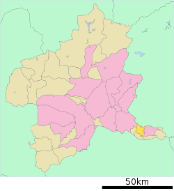

 Ōra
ŌraCoordinates: 36°16′N 139°28′E / 36.267°N 139.467°ECoordinates: 36°16′N 139°28′E / 36.267°N 139.467°E Country Japan Region Kantō Prefecture Gunma Prefecture District Ōra District Area – Total 31.12 km2 (12 sq mi) Population (September 1, 2007) – Total 27,201 – Density 874.07/km2 (2,263.8/sq mi) Time zone Japan Standard Time (UTC+9) City symbols - Tree Japanese Red Pine - Flower Azalea Phone number 0276-88-5511 Address 3040 Ōaza Nakano, Ōra-machi, Gunma-ken
370-0692Website Town of Ōra 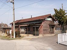 Shinotsuka Station
 This article is about the town in Gunma Prefecture, Japan. For another town with a similar name in Kagoshima Prefecture, see Ōura, Kagoshima.
Ōra (邑楽町 Ōra-machi) is a town located in Ōra District, Gunma, Japan.
As of September 1, 2007, the town has an estimated population of 27,201 and a density of 874.07 persons per km². The total area is 31.12 km².
Contents
Surrounding municipalities
Education
- Primary Schools
- Nakano Elementary School
- Nakanohigashi Elementary School
- Takashima Elementary School
- Nagara Elementary School
- Junior High Schools
- Ōra Junior High School
- Ōraminami Junior High School
Notable places
- Ōra Symbol Tower
- Matsumoto Park
- Tatara Marshland
External links
 Media related to Ōra, Gunma at Wikimedia Commons
- Ōra official website (Japanese)

This Gunma Prefecture location article is a stub. You can help Wikipedia by expanding it. - Primary Schools


