- Dixie Lee Junction, Tennessee
-
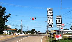 The intersection of US-70 and US-11 at Dixie Lee Junction
Dixie Lee Junction is an unincorporated community in Loudon County, Tennessee, United States, situated at the intersection of U.S. Route 70 and U.S. Route 11. The community is named for its historical location at the junction of the eastern leg of the Dixie Highway (which followed US-70 through the region) and the Lee Highway (which followed US-11).[1] From the advent of automobile travel in the late 1920s until the construction of the Interstate Highway System in the late 1950s and 1960s, these two highways were major cross-country routes, and Dixie Lee Junction developed as a "last chance" stopover for tourists traveling southward from Knoxville. While the completion of the interstates drew away most of the cross-country traffic, the US-70/US-11 intersection still serves a strategic role as the western end of the four-lane Kingston Pike, a major commercial thoroughfare in western Knox County.[1]
The Dixie Lee Junction community lies adjacent to the town of Farragut, with the Knox-Loudon county line (which runs perpendicular to Kingston Pike) being the technical boundary between the two communities. US-70 approaches Dixie Lee Junction from Kingston to the west, and US-11 approaches from Lenoir City to the southwest. The merged highways then continue eastward for 20 miles (32 km) through Farragut and Knoxville. Two major interstate highways, Interstate 40 and Interstate 75, merge just northwest of Dixie Lee Junction.
The Dixie Highway was conceived in 1914 to provide a convenient route from the Midwestern United States to Florida. Its eastern section entered downtown Knoxville via Broadway before veering westward along Cumberland Avenue and out into West Knoxville along Kingston Pike.[1] The Lee Highway which connected New York and San Francisco, entered Knoxville from Rutledge to the northeast, and merged with the Dixie Highway in downtown Knoxville.
Knoxville lay along the Dixie Highway roughly halfway between the Midwestern states and Florida, and thus made a convenient place for Florida-bound tourists to stop for the night. Throughout the 1930s, 1940s, and 1950s, Kingston Pike was lined with motor courts and motels, and restaurants with oddly-shaped buildings and flashy signs designed to catch the attention of passers-by.[1] Businesses in Dixie Lee Junction during this period consisted of "last-chance" ventures that provided food, fuel, and other supplies before south-bound drivers entered a predominantly-rural stretch of the highway en route to Chattanooga.[1]
There is another Dixie Lee Junction, formally named simply Dixie Lee, in Marion County, Tennessee, where Lee Highway intersects the western leg of the Dixie Highway just west of Kimball.
References
Coordinates: 35°51′37″N 84°13′33″W / 35.86027°N 84.22570°W
Municipalities and communities of Loudon County, Tennessee Cities 
Town Unincorporated
communitiesDixie Lee Junction | Tellico Village
Footnotes ‡This populated place also has portions in an adjacent county or counties
Categories:- Tennessee geography stubs
- Populated places in Loudon County, Tennessee
- Unincorporated communities in Tennessee
- Dixie Highway

Wikimedia Foundation. 2010.