Mirror Lake (Utah)

Mirror Lake (Utah)
Mirror Lake
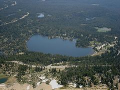
Mirror Lake as seen from Bald Mountain. The Mirror Lake Highway is in the foreground.
Location Uinta Mountains, Duchesne County, Utah, USA
Coordinates 40°42′16.51″N 110°53′17.47″W / 40.7045861°N 110.8881861°W / 40.7045861; -110.8881861Coordinates: 40°42′16.51″N 110°53′17.47″W / 40.7045861°N 110.8881861°W / 40.7045861; -110.8881861
Basin countries United States
Surface area 53.4 acres (0.216 km2)[1]
Max. depth 36 ft (11 m)
Surface elevation 10,050 ft (3,060 m)[2]
References [1][2]

Mirror Lake is a lake in the high Uinta Mountains in Utah. It is a popular fishing and recreation spot. The lake has a Forest Service campground, picnic facilities, and a boat ramp for non-motorized watercraft. Access to the lake is by the Mirror Lake Highway, which is only open during the summer.

The lake's name comes from the near-perfect reflection of the surrounding mountains and trees seen from a roadside overlook or from the shore. The shoreline is owned by the Wasatch-Cache National Forest and has full public access.

Mirror Lake includes the adjacent Mirror Lake Campground, with latrines, day-use areas and 94 campsites. The water that enters the lake is overflow from Pass Lake located just above Mirror Lake. The outflow is the headwaters of the Duchesne River.

References

  1. ^ a b Mirror Lake Campground and Picnic Area
  2. ^ a b North Eastern Utah Fishing Waters

External links


Wikimedia Foundation. 2010.

Игры ⚽ Нужно сделать НИР?

Look at other dictionaries:

  • Mirror Lake — may refer to: North America Mirror Lake, Alaska Mirror Lake (Alberta) Mirror Lake (British Columbia) Mirror Lake (California) Mirror Lake (Tuftonboro, New Hampshire) Mirror Lake (New York), one of two lakes in Lake Placid, New York Mirror Lake… …   Wikipedia

  • Utah State Route 150 — State Route 150 Mirror Lake Highway Route …   Wikipedia

  • Utah State Route 143 — Basisdaten Gesamtlänge:  51.21 mi. / 82,40 km Eröffnung:  …   Deutsch Wikipedia

  • Utah State Route 32 — Infobox road state=UT type=SR route=32 section=109 maint=UDOT length mi=29.053 length round=3 length ref= [http://www.dot.utah.gov/main/uconowner.gf?n=7022617868261736 UDOT Highway Reference, SR 32] ] established=1989 direction a=South terminus a …   Wikipedia

  • Lake Placid, New York — Infobox Settlement official name = Lake Placid, New York settlement type = Village nickname = motto = imagesize = image caption = The lake after which the village is named image mapsize = 250px map caption = pushpin mapsize1 = map caption1 =… …   Wikipedia

  • Lake Misurina — Lago di Misurina at Auronzo di Cadore Location Province of Belluno, Veneto Coordinates …   Wikipedia

  • Utah Museum of Fine Arts — infobox Museum name= The Utah Museum of Fine Arts established= 1951 location= Marcia John Price Museum Building Salt Lake City, Utah type= Art museum visitors= director= David L. Dee latitude= 40.7602 longitude= 111.8432 website= [http://www.umfa …   Wikipedia

  • Kamas, Utah — Infobox Settlement official name = Kamas, Utah settlement type = City nickname = motto = imagesize = image caption = image |pushpin pushpin label position =left pushpin map caption =Location within the state of Utah pushpin mapsize = |mapsize =… …   Wikipedia

  • Highline Trail, Utah — Infobox Hiking trail Name=Highline Trail Photo= Caption= Location=Uinta Mountains Length= 60 miles Start/End Points= Use=Hiking ElevChange= HighPoint= LowPoint= Difficulty= Season= Months= Sights=Kings Peak Hazards=The Highline Trail is a trail… …   Wikipedia

  • Devil's Lake State Park (Wisconsin) — This is about the state park in Wisconsin. For parks with similar names, see Devil s Lake State Park (disambiguation) Coordinates: 43°24′53″N 89°42′47″W / 43.41472°N 89.7 …   Wikipedia

Share the article and excerpts

Direct link
Do a right-click on the link above
and select “Copy Link”