- Utah State Route 150
-
State Route 150
Mirror Lake Highway 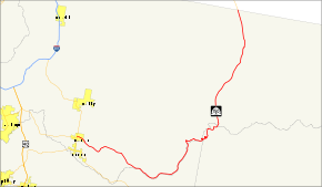
Route information Defined by Utah Code §72-4-120 Maintained by UDOT Length: 54.742 mi[1] (88.099 km) Existed: 1933 – present Major junctions West end:  SR-32 in Kamas
North end:  WYO 150 near Evanston, WY
Highway system State highways in Utah
Interstate • US • State (Parks) • Scenic←  SR-149
SR-151  →
→State Route 150, also known as the Mirror Lake Highway, is a state highway in the U.S. state of Utah. It is named for Mirror Lake, a picturesque lake that the highway passes along the way. It is also a USDA Forest Service Byway.[2]
Contents
Route description
The highway begins at the intersection of Main Street (SR-32) and Center Street in Kamas and heads east on the latter as a two-lane undivided highway. Once exiting Kamas, the route dips southeast and continues as such until reaching Samak, where the road turns northeast briefly. Soon after, the highway turns south and southeast again. After continuing in a general southeast direction, the highway turns northeast and north and continues as such until reaching the Wyoming border south of Evanston.[3]
The road is the highest paved road in Utah when it crosses Bald Mountain Pass at an altitude of 10,715 ft (3,266 m).[4]
During the winter months the road is closed to automobiles and is used by snowmobiles.
History
The state legislature designated SR-150 in 1933, running east from SR-35 (now SR-32) in Kamas to the Wasatch-Cache National Forest boundary.[5] In 1953, it was extended east and north via Mirror Lake to the Wyoming state line.[6]
Major intersections
County Location Mile[1] Destinations Notes Summit Kamas 0.000 SR-32 (Main Street)Western terminus 54.742 WYO 150Eastern terminus (Wyoming border) 1.000 mi = 1.609 km; 1.000 km = 0.621 mi References
- ^ a b Utah Department of Transportation, Highway Reference Information: SR-150PDF (35.2 KB), updated May 2008, accessed June 2008
- ^ Mirror Lake Scenic Byway - UT Section
- ^ Google, Inc. Google Maps – Google Maps overview of SR-150 (Map). Cartography by Google, Inc. http://maps.google.com/maps?f=q&hl=en&geocode=&q=UT-150&sll=37.0625,-95.677068&sspn=32.885543,83.320312&ie=UTF8&ll=40.829398,-110.886383&spn=0.490461,1.30188&z=10. Retrieved June 8, 2009.
- ^ Deseret Morning News | Enjoy Utah's scenic heights from your car
- ^ "Designation of Secondary State Roads", Chapter 30, Session Laws of Utah, 1933: "(150) From Kamas Main street easterly to forest boundary line."
- ^ "Designation of State Roads", Chapter 45, Session Laws of Utah, 1953: "Route 150. From route 35 in Kamas easterly to Mirror Lake and northerly to Utah-Wyoming state line en route to Evanston, Wyoming."
External links
Categories:- Transportation in Summit County, Utah
- Transportation in Duchesne County, Utah
- Transportation in Wasatch County, Utah
- State highways in Utah
- Features of the Uinta Mountains
- Utah Scenic Byways


Wikimedia Foundation. 2010.