- Hurstbridge railway line, Melbourne
VictorianRailwayLineInfobox
type = mel
name = Hurstbridge
yearcommenced = 1888
yearcompleted = 1912
yearclosed =
fate =
lengthkm =
stations =23
tracks =
users =Connex Melbourne
servicepattern = Express Jolimont -- Clifton Hill
RollingStock = north
connections = Epping line
formerconnections = Inner Circle and Mont Park lines
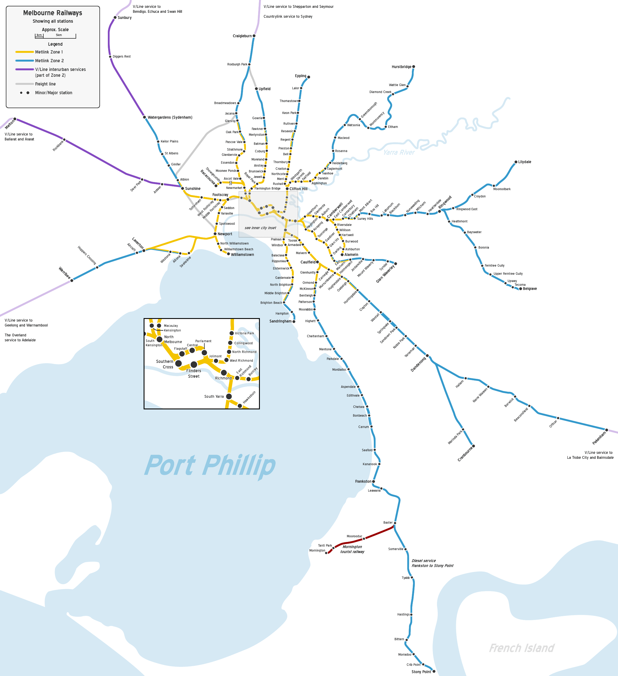
The Hurstbridge railway line is asuburb an railway inMelbourne ,Australia . It shares the line with the Epping Railway Line untilClifton Hill , then heads in a northeast direction through theCity of Yarra ,City of Darebin ,City of Banyule , and theShire of Nillumbik . Some of the suburbs served by the line includeEast Melbourne , Collingwood, Fairfield, Heidelberg,Greensborough , Eltham, andHurstbridge . It has 23 stations inMetcard ticketing Zones 1 and 2.Description
The Hurstbridge line traverses the rolling hills of Melbourne's north-eastern suburbs, at times cutting across hills and valleys, resulting in a somewhat windy and hilly line. It includes the only three tunnels on the suburban electrified system other than the underground city loop, although none of the three tunnels are particularly long nor deep.
The first section from
Flinders Street station to Victoria Park was actually built later than the rest of the line, which was originally connected to the rest of the suburban system via the now-closed "Inner Circle" line. There is evidence that the line was originally intended to be connected via this route, but geography and existing suburbs made it a problematic situation. The section uses two tunnels to cut under a low ridge just east of Melbourne, and most of the rest is built on an embankment that carries the line above numerous main roads and suburban side streets.After Clifton Hill the line roughly parallels the north bank of the
Yarra River , cutting across a number of watercourses flowing into the Yarra, and the ridges between them. At Heidelberg is the third tunnel. The line then encounters steeper grades until Eltham, after which it follows the valley of Diamond Creek, with easier grades but a windier route, with some curves having speed limits as low as convert|40|km/h|mph|abbr=on|lk=on. This line boasts two of the largest bridges on the suburban network, one over the Merri creek between Clifton Hill and Westgarth, and the other on the up side of Darebin, crossing Darebin Creek.Apart from the first section of the line, it has numerous
level crossing s, plus a number of unprotected crossings with private driveways past Diamond Creek, and also a number of bridges over or under roads. The area traversed by the line is mostly built-up suburbs in the inner area, thinning out after Greensborough, and much of the outer end of the line is surrounded patches of bush and paddocks.Infrastructure
The Hurstbridge line is both notable and notorious for having several single-track sections. The unusually large number of single track sections is due to constraints imposed by the underlying infrastructure, geography and lack of government investment. These unduplicated sections give the Hurstbridge line several bottlenecks at which trains must sometimes wait for the tracks to clear before proceeding. The single-track sections are as follows:
*Between Clifton Hill and Westgarth is a single-track railway bridge over Merri Creek (recently announced to be duplicated- see [http://www.doi.vic.gov.au/DOI/Internet/transport.nsf/AllDocs/74864007B5D7C94ECA2571F800027215?OpenDocument Department of Infrastructure Website] ).
*Between Heidelberg and Rosanna is a single-track railway bridge over Burgundy Street, followed by a short single-track tunnel.
*The convert|15|km|mi|lk=on|sing=on section of track between Greensborough and Hurstbridge. Eltham and Diamond Creek railway stations each have two platforms, providing points at which trains can pass. This section of unduplicated track includes a timber trestle bridge near Eltham Station that has heritage protection. The bridge has a convert|40|km/h|mph|abbr=on speed limit.These single track sections restrict the number of trains that can be timetabled to run on the line and also regularly delay trains by up to 10 minutes waiting for the single tracks to clear.The Hurstbridge line is the only electrified line in Melbourne to still use token
safeworking systems. Greensborough to Eltham is controlled by the "Miniature electric staff" system and Eltham to Hurstbridge by the "Staff and Ticket" system. The latter section can be divided into two sections at Diamond Creek, allowing trains to cross at that station. Eltham, Diamond Creek, and Hurstbridge still retain some semaphore signals. However, these methods of safeworking are being gradually phased out of use on these sections, as they will get Automatic Electronic Signaling to bring them in line with the rest of the metropolitan network. Both the "Miniature electric staff" system & the "Staff and Ticket" system will be out of service before the end of 2010.Intermediate terminating facilities are provided at Victoria Park (not normally used except for trains using the stabling siding), Clifton Hill (not normally used), Heidelberg (only normally used by a couple of unadvertised placement trips a day), Macleod, and Greensborough. Also, in theory, trains could terminate anywhere on the sections controlled by Electric Staff or Staff and Ticket, but in practice the only place trains on these sections terminate short of the terminus is Eltham. Stabling facilities are provided at Victoria Park, Macleod, Eltham, and Hurstbridge.
Macleod station is the only station on the Hurstbridge line with more than two platforms. Macleod station has a third platform provided for in the 1970s used during peak periods to provide a place at which trains can enter the system or terminate.
Line speeds are:
* Flinders Street-Clifton Hill: convert|55|km/h|mph|abbr=on
* Clifton Hill-Heidelberg: convert|80|km/h|mph|abbr=on
* Heidelberg-Eltham: convert|75|km/h|mph|abbr=on
* Eltham Hurstbridge: convert|65|km/h|mph|abbr=onHistory
The first section of the Hurstbridge line to open was between Victoria Park (then named Collingwood) and Heidelberg, in May 1888, although there is some evidence that the contractors building the line operated services prior to that.At this time, the line was connected to other lines via a line from Royal Park to Clifton Hill, most of which comprised what was later known as the "Inner Circle" line. This connection was opened at the same time.
A more direct connection, between Princes Bridge and Victoria Park (as Collingwood was renamed at the same time) was opened in October 1901. In June the following year the line was extended to Eltham, and ten years later (June 1912) to Hurst's Bridge (now Hurstbridge). In 1912 the short Mont Park branch was built branching from Macleod station to serve the Mont Park Asylum.
In the same year as the line reached Hurstbridge, the line between Westgarth and Alphington was duplicated. (The short single-track section between Clifton Hill and Westgarth crosses the moderately-deep valley of the Merri Creek. It remains single track to this day, although duplication of this section will soon begin construction.)
In April 1921 automatic signalling was implemented between Princes Bridge and Clifton Hill.
A few months later, the line (from Princes Bridge) was electrified to Heidelberg, followed by electrification to Eltham in April 1923 and Hurstbridge in August 1926.
In September 1926 the single-line section between Clifton Hill and Westgarth was converted to Lever Locking and Track Control signalling, followed by Alphington to Heidelberg in June 1927.
In June 1949 Ivanhoe to Heidelberg to was duplicated and provided with automatic signalling.The same was done to the Alphington to Ivanhoe section in December 1951.
Duplication continued between Heidelberg and Macleod in December 1958, except for a short section after Heidelberg where the line crosses a bridge then goes through a tunnel. That section also remains single to this day.
On two consecutive days in September 1964 automatic signalling was provided between Westgarth and Fairfield, and Fairfield and Alphington.
Macleod to Greensborough was duplicated and converted to automatic signalling in August or September 1979.
Line guide
Bold stations are termini, where some train services terminate; "italic" stations are staffed; and stations with an asterisk (*) are staffed during morning peak periods.
External links
* [http://www.vicsig.net/index.php?page=infrastructure§ion=lineguide&line=Hurstbridge Statistics and detailed schematic map] at the [http://www.vicsig.net/ VicSig] enthusiast website
Wikimedia Foundation. 2010.