Dosewallips River

Dosewallips River
Dosewallips River
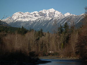
Mount Constance (7,756 ft) above the Dosewallips River in Dosewallips State Park
Country United States
State Washington
County Jefferson
Source Olympic Mountains
 - coordinates 47°47′1″N 123°20′18″W / 47.78361°N 123.33833°W / 47.78361; -123.33833 [1]
Mouth Hood Canal
 - coordinates 47°41′6″N 122°53′47″W / 47.685°N 122.89639°W / 47.685; -122.89639 [1]
Location of the mouth of the Dosewallips River in Washington

The Dosewallips River (pronounced "doh'-si-wall-ips"[2]) is a river situated on the Olympic Peninsula in the U.S. state of Washington. It rises near Mount Anderson in the Olympic Mountains within Olympic National Park and drains to Hood Canal and thence to the Pacific Ocean.

The river originates in two forks, which join about five miles from the headwaters. The National Park Service maintains trails and campsites along both forks, including one at the fork itself. The road leading to the trailhead was washed out in January 2002,[3] and the ranger station near the trailhead has been abandoned.

The entire estuary of the Dosewallips is within Dosewallips State Park and ongoing restoration efforts led by Wild Fish Conservancy, the Port Gamble S'Kalallam Tribe, and the Hood Canal Coordinating Council are intended to improve salmon habitat through the reconnection of the river to its historical floodplain.

Contents

Name

The name Dosewallips comes from a Twana Indian myth about a man named Dos-wail-opsh who was turned into a mountain at the river's source.[4] There are also several Klallam legends about the "Great Changer", Doquebatl, who transformed a mythical Klallam chief into a mountain at the headwaters of the Dosewallips River. In another story Doquebatl changed a woman into Mount Rainier and her son into Little Tahoma.[5]

See also

  • List of Washington rivers

References

  1. ^ a b U.S. Geological Survey Geographic Names Information System: Dosewallips River
  2. ^ Goode, J. Paul; Veregin Howard, Ph.D. (June 2006). Rand McNally Goode's World Atlas (21 edition ed.). Rand McNally & Company. pp. 288. ISBN 0528853392. http://www.amazon.com/gp/reader/0528853392/ref=sib_dp_srch_pop?v=search-inside&keywords=dosewallips&go.x=0&go.y=0&go=Go%21#. Retrieved 2008-03-10. 
  3. ^ Washington Trails Association
  4. ^ Phillips, James W. (1971). Washington State Place Names. University of Washington Press. ISBN 0-295-95158-3. 
  5. ^ Parratt, Smitty (1984). Gods & goblins: A Field Guide to Place Names of Olympic National Park. CP Publications. p. 38. ISBN 0-914195-00-X. 

External links


Wikimedia Foundation. 2010.

Игры ⚽ Поможем сделать НИР

Look at other dictionaries:

  • Dosewallips River — im Dosewallips State Park, im Hintergrund der Mount ConstanceVorlage:Infob …   Deutsch Wikipedia

  • Dosewallips River — 47° 41′ 06″ N 122° 53′ 46″ W / 47.685, 122.896 …   Wikipédia en Français

  • Dosewallips River —  Washington …   Bryson’s dictionary for writers and editors

  • Dosewallips State Park — Mündung des Dosewallips River im Dosewallips State Park Der Dosewallips State Park ist ein State Park im Jefferson County im US Bundesstaat Washington. Der 172 Hektar große Park liegt etwa 800 Meter südlich von Brinnon am U.S. Highway 101 am Fuß… …   Deutsch Wikipedia

  • Dosewallips State Park — Salt marsh shoreline in winter, Dosewallips State Park Dosewallips State Park in Jefferson County, Washington is one of the Washington State Parks.[1] It consists of 425 acres (172 ha) with 5,500 feet (1,700 m) of saltwater shoreline on …   Wikipedia

  • Skokomish River — For the similarly named river also in Washington State, see Skykomish River. Skokomish River Skokomish River Delta on Hood Canal Origin Mount Skokomish, Olympic Mountains(North Fork); Sundown Pass …   Wikipedia

  • Trails of Olympic National Park — There are many diverse trails within Olympic National Park. These trails traverse many different biomes, allowing hikers to explore from the coast of the Pacific Ocean to the summit of Mount Olympus. The trails vary in length from less than a… …   Wikipedia

  • List of rivers of Washington — This is a list of rivers in the U.S. state of Washington.By Drainage BasinThis list is arranged by drainage basin, with respective tributaries indented under each larger stream s name.Strait of Georgia* Fraser River (BC) **Chilliwack River… …   Wikipedia

  • Liste der Flüsse in Washington — Diese Liste der Flüsse in Washington nennt die Flüsse in diesem Bundesstaat der Vereinigten Staaten nach Einzugsgebieten und in alphabetischer Reihenfolge geordnet. Inhaltsverzeichnis 1 Nach Einzugsgebieten 1.1 Straße von Georgia 1.2 Puget Sound …   Deutsch Wikipedia

  • Liste der Flüsse in den Vereinigten Staaten — Die folgende Liste zeigt die Flüsse in den Vereinigten Staaten. A Alabama River Alabama Allegheny River Pennsylvania, New York Alsea River Oregon Altamaha River Georgia Amargosa River Kalifornien American River Kalifornien Anacostia River… …   Deutsch Wikipedia

Share the article and excerpts

Direct link
Do a right-click on the link above
and select “Copy Link”