- Quaboag River
Infobox River | river_name = Quaboag River
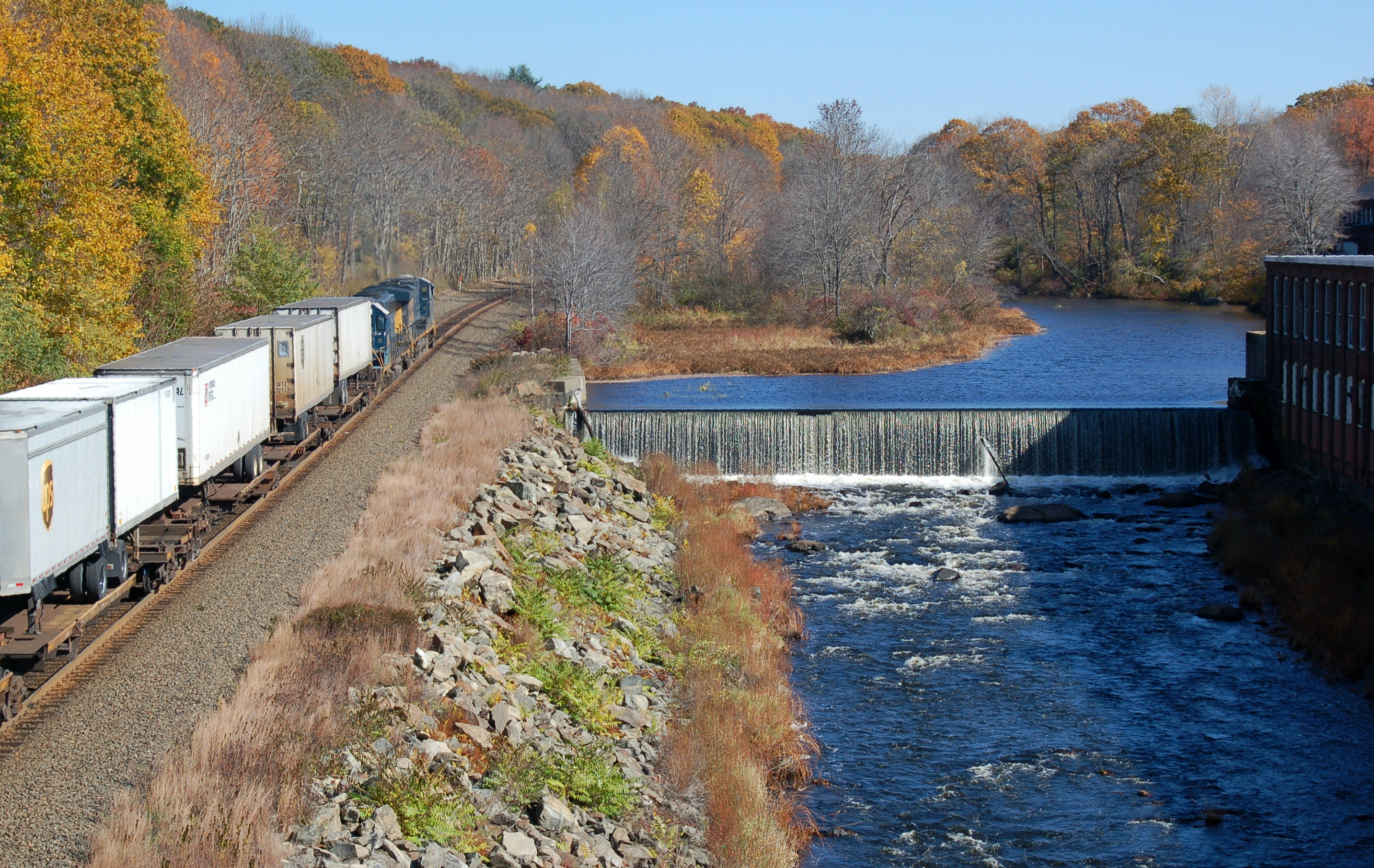
caption = Quaboag River at Warren
origin =Quaboag Pond
mouth =Three Rivers, Massachusetts
basin_countries =
length = 24 mi (39 km)
elevation = 594 ft (181 m)
mouth_elevation = 290 ft (88.39 m)
discharge = 132 ft³/s (3.74 m³/s)
watershed = 150 mi² (388.5 km²)The Quaboag River is aMassachusetts river that heads atQuaboag Pond south ofEast Brookfield, Massachusetts at an elevation of 594 feet (181 m) MSL. It continues to the town ofThree Rivers, Massachusetts , at an elevation of 290 feet (88.39 m) MSL.History
This river receives its name from
Quaboag Pond , an Indian name meaning "red-water (place or pond)". At one time, this pond was called Podunk Pond and, contrary toUSGS data (below), this source is "not" in Southbridge. Early industry started along the Quaboag River downstream from West Brookfield, where the river started a 300-foot (91.44 m) change in elevation providing significant waterpower. Major heavy industry was located inWarren, Massachusetts because of the available waterpower from the river. Many of the dams on the river, used to providewaterpower , were destroyed during floods and not repaired or replaced. Parts of them remain, providing a hint of the river’s powerful past.Description
The Quaboag River heads at
Quaboag Pond , flows through the towns of Brookfield, West Brookfield whereLake Wickaboag drains into it, and Warren before joining theWare River and Swift River in Three Rivers, to form theChicopee River . This river is therefore part of theChicopee River Watershed .Watershed
Numerous local brooks and streams from the towns of East Brookfield, Brookfield, West Brookfield, and Warren drain the watershed into the Quaboag River.
Lake Lashaway in East Brookfield drains intoQuaboag Pond and several other significant water sources drain into it. There are also several wetlands associated with this watershed, the two mayor ones being the "Great Swamp" south of Brookfield, and the "Allen Swamp" south of East Brookfield.Recreational use
Whitewater kayakers and canoeists paddle the Quaboag from a put-in at Lucy Stone Park in Warren, downstream to a take-out along Route 67. The river is Class III and features several named rapids, Mousehole and Trestle Rapid above the dam, and, downstream, Angel's Field and Devil's Gorge, which contains an abrupt four-foot waterfall called Quaboag Drop. The river has a large watershed, holds its water well (is well formed), and is runnable at levels above four feet on the Brimfield [http://waterdata.usgs.gov/ma/nwis/uv/?site_no=01176000&PARAmeter_cd=00065,00060 USGS gauge] . It contains one mandatory
portage around an unrunnable dam next to a factory. This dam is shown in the title block.Coordinates
*coord|42|10|50|N|72|21|54|W Mouth in Three Rivers
*coord|42|12|47|N|72|11|43|W Passage through Warren
*coord|42|11|45|N|72|04|13|W Head south of East BrookfieldReferences
* [http://www.geocities.com/Heartland/Meadows/7937/qupo.htm Podunk Pond reference]
*Gnis|609598|Quaboag River technical data
*Gnis|609834|Quaboag Pond data
* [http://waterdata.usgs.gov/ma/nwis/uv/?site_no=01176000&PARAmeter_cd=00065,00060 Stream flow data]
Wikimedia Foundation. 2010.