East Brookfield River

East Brookfield River

Infobox River | river_name = East Brookfield River


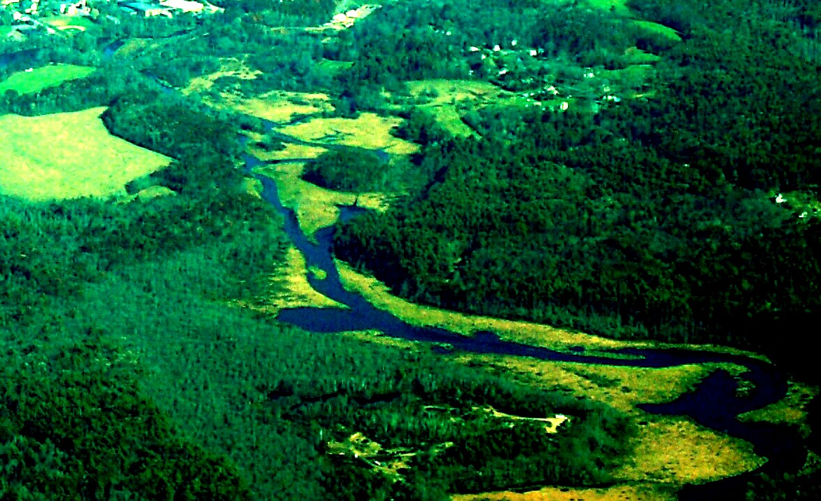
caption = East Brookfield River at East Brookfield
origin = Lake Lashaway
mouth = Quaboag Pond
basin_countries =
length = 2.2 mi (3.2 km)
elevation = 614 ft (187.14 m)
mouth_elevation = 594 ft (181 m)
discharge = 11.5 ft³/s (0.325 m³/s)
watershed = 15 mi² (38.85 km²)
The East Brookfield River is a Massachusetts river that heads at Lake Lashaway in East Brookfield, Massachusetts at an elevation of 614 feet (187.14 m) MSL. It continues to Quaboag Pond, at an elevation of 594 feet (181.05 m) MSL.

History

This river receives its name from East Brookfield, Massachusetts. It is part of the Chicopee River Watershed.

Watershed

This river starts at the Lake Lashaway Dam, near State Route 9 and continues through wetlands to Quaboag Pond. Numerous local brooks and streams from the towns of East Brookfield, North Brookfield, and Spencer drain the watershed into Lake Lashaway and the East Brookfield River. About one mile from its mouth at Quaboag Pond, the Seven Mile River joins, draining water from Spencer and surrounding areas.

Coordinates

*coord|42|13|34|N|72|03|00|W Head at Lake Lashaway Dam
*coord|42|12|04|N|72|03|27|W Mouth at Quaboag Pond

References

*Gnis|609598|Quaboag River technical data
*Gnis|609834|Quaboag Pond data


Wikimedia Foundation. 2010.

Игры ⚽ Поможем написать реферат

Look at other dictionaries:

  • Seven Mile River (East Brookfield River) — Infobox River | river name = Seven Mile River caption = Seven Mile River near Wire Village origin = Browning Pond, Oakham / Spencer mouth = East Brookfield River basin countries = length = 7.8 mi (12.55 km) elevation = 745 ft (227.1 m) mouth… …   Wikipedia

  • East Brookfield, Massachusetts — Infobox Settlement official name = East Brookfield, Massachusetts nickname = motto = imagesize = 250px image caption = The old East Brookfield Municipal Building, will eventually be torn down because it is in disrepair image mapsize = 250px map… …   Wikipedia

  • Brookfield, Massachusetts —   Town   Central Street in 1908 …   Wikipedia

  • Brookfield, Wisconsin — Infobox Settlement official name = Brookfield, Wisconsin nickname = motto = (from tourist department) Minutes from Milwaukee, Miles from Expected imagesize = image caption = image mapsize = 250px map caption = Location in Wisconsin subdivision… …   Wikipedia

  • Brookfield, New York — Infobox Settlement official name = Brookfield, New York settlement type = Town nickname = motto = imagesize = image caption = image |pushpin pushpin label position = pushpin map caption =Location within the state of New York pushpin mapsize =… …   Wikipedia

  • Brookfield, Vermont — Infobox Settlement official name = Pagename other name = native name = nickname = settlement type = Town motto = imagesize = 155px image caption = Brookfield Floating Bridge flag size = image seal size = image shield = shield size = image blank… …   Wikipedia

  • River Cladagh — This article is about the Co. Fermanagh river. For the river which flows from Co. Cavan into Co. Fermanagh and Upper Lough Erne, see River Cladagh (Swanlinbar). Coordinates: 54°17′10.73″N 7°47′29.19″W /  …   Wikipedia

  • Quaboag River — Infobox River | river name = Quaboag River caption = Quaboag River at Warren origin = Quaboag Pond mouth = Three Rivers, Massachusetts basin countries = length = 24 mi (39 km) elevation = 594 ft (181 m) mouth elevation = 290 ft (88.39 m)… …   Wikipedia

  • Ottawa River Parkway — Interchange with Parkdale Ave The Ottawa River Parkway is a four lane scenic parkway along the Ottawa River in Ottawa, Ontario, Canada. It runs from Carling Avenue near Connaught Avenue, to Booth Street at the Canadian War Museum. It is… …   Wikipedia

  • Mystic River — For other uses, see Mystic River (disambiguation). Mystic River River …   Wikipedia

Share the article and excerpts

Direct link
Do a right-click on the link above
and select “Copy Link”