- Kambia District
-
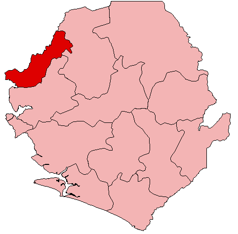
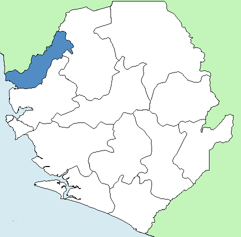
Kambia District Country Sierra Leone Capital Kambia Largest city Kambia Province Northern Province Government – Type District Council – Council Chairman Osman Sheriff Fofana (APC)[1] Population (2010) – Total 304,357 [2] Time zone Greenwich Mean Time (UTC-5) 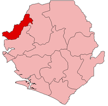 Location of Kambia District in Sierra Leone
Kambia District is a district in the Northern Province of Sierra Leone. Its capital and largest city is Kambia. The other major towns include Morebaya, Kasirie, Kamassassa, Kukuna and Mange. The district has a population estimated at 304,357.
Kambia District borders the Republic of Guinea to the north, Port Loko District to the south and Bombali District to the east. The district provides an important Trade route to Freetown and Conakry.
The district occupies a total area of 3,108 km² and is divided into 7 Chiefdoms namely, Bramaia, Gbinleh- Dixing, Magbema, Mambolo, Masungbola, Samu and Tonko-Limba. A Paramount Chief and a council of Tribal Authorities govern each of these Chiefdoms.
The central government is represented by a District Council Chairman and elected District Council. These institutions were destroyed during the civil conflict and are now being rehabilitated.
Contents
History
Before the British and Portuguese arrived in Sierra Leone, a farmer and hunter named Pa Kambi settled on the banks of the river where Kambia lies today. As other natives from neighboring locales wandered about, they discovered Pa Kambi thriving on his trades. They, too, decided to settle down and named the area Kambia, meaning the town of Pa Kambi.
The Kambia District was formed in 1928 as a split of the now-defunct Karene District and Port Loko District. Population in the district has increased steadily over the past 42 years: from 137,806 in 1963, to 155,341 in 1974 to 186,231 in 1985 to the 2004 population of 270,460.
Ethnic group
The vast majority of the population of Kambia District are from the Temne, Susu, and Limba ethnic group.
Religion
About 70% of the population of Kambia District are followers of Muslim and Islam dominates their religious and cultural practices; Christians make up 20% and 10% belong to traditional religions.
International Health Operations in the district
Kambia District is home to several international health operations, including the International Medical Corps who arrived in 2001, Kambia Hospital, a United Kingdom-based non-profit organization that has operated in Kambia since 1992 and Doctors without Borders, a France-based medical non-profit agency that operates across the world in poverty-stricken areas.
Government
The District has eight representatives in the Sierra Leonean parliament, of which seven were elected for a 5 year term. The district is stronghold of the ruling All People's Congress (APC). Following is a list of the 9 Representatives and their affiliations:
Name Party Dauda Sulaiman Kamara APC Ibrahim S. Sesay APC Amara Samba Sheriff APC Ibrahim Sorie Suma APC Isatu Kamara APC Alusine Fofana APC P.C. Kelfa Bai Sankoh Non Condition
All the chiefdoms had medical centres or posts with the only referral hospital located in Kambia town, the district headquarter town. There are less transport facilities in almost all these places to the headquarter town. This made it possible for the highest number of death rate especially infant and maternal mortality in Kambia than all other districts in the country. There are 13 secondary schools in the district, located in Kambia town, Rokupr, Kasirie, Kychom, Mambolo, Tombowala, Madina, Kamassassa and Kukuna; three of the 13 of the secondary schools together with the hospital were all burnt down in February 1999 during the intensive fighting in the district, while the remaining 10 were systematically vandalised to an extent of completely ruining them.
As the district was hit later by the war than most other areas of Sierra Leone, it hosted a huge number of Internally Displaced Persons (IDPs) until September 1998 when it sustained a heavy rebel attack by the RUF rebel fighters. Much of the population, together with over 40,000 IDPs who had sought refuge in the district fled to neighbouring Guinea. The inhabitants of this district constitute the majority of the refugees in the Forecariah prefecture (District).
Economy
The district is considered as the main rice bowl of Sierra Leone. It has a large agricultural zone with extensive swamp areas found in every chiefdom, but more in the south-west, dominated by mangroves and large river estuaries. The rest of the vegetation consists of a mix between forest to the south and grassland or savannah to the north east. With annual rainfall above 2,500mm, the district has an impressive potential for upland, inland valley swamp and mangrove swamp farming.
The population is mainly farmers, practising off-season activities such as gardening, hunting and as migrant labour. The major food crops grown by the people are, rice (the staple food), cassava, millet, sweet potatoes and sorghum, while groundnuts and maize constitute the major cash crops.
In addition to farming, fishing along the many river estuaries and streams is practised by a large proportion of the population of the district. Fishing is an important source of income for the district, as traders come from other areas on both sides of the border to the fishing Islands and enclaves. This sector more than any other, demonstrates the division of labour between men and women in the community. While the men are the fishers, the fish trade is completely dominated by the women.
Animal raising of sheep and goats on small-scale units has declined because of forced sales in order to compensate for the chronic fall in agricultural production and the subsequent rural poverty.
Cattle rearing by groups of resident Fullahs in the North-east of the district has similarly disappeared as they have migrated to Guinea, due to the protracted civil war. An FAO report in 1996 stated that 40% of Sierra Leonean livestock was now in Guinea.
Outside agriculture, commerce is probably the most important source of income for the population. In addition to domestic trade, cross-border trade expanded to all the different chiefdoms in the district. This is due mainly to the growth of outside agriculture; commerce is probably the most important source of the traditional weekly market villages known as the "LOUMAH" along the border. Although disrupted during the war, these weekly markets have resumed and increased in number from 5 in the pre-war period to 15, with traders coming from various parts of both countries, from as far as Conakry, Nzerekore, Macenta and Faranah in Guinea and from provincial Headquarter towns of Bo, Kenema, Kono, Makeni and the capital city of Freetown, giving these village markets a true international character. The products offered are mainly agricultural and food products, clothes and some imported consumer goods.
Like other commercial activities, women traders from both sides of the border were the principal sellers in such markets, travelling from one town and village to the other. However men are increasingly participating in commerce and a pattern of division of labour between sexes can be observed as the women trade mainly in agricultural products and processed food items while the men trade mainly in imported consumer goods.
Problems of the district
Kambia district was the last to experience the civil war, with the first wave of attacks by the Revolutionary United Front (RUF) in January 1995 and later in 1998. Finally, in February 1999, the rebels occupied all the major towns in the district including the headquarter town of Kambia until disarmament in May 2001. It is also here that the reintegration efforts have been less successful and have fallen victim to donor fatigue.
In the early phase of the war, this border district functioned as host for a large number of internally displaced persons and transit zones for refugees. Later in the war, it became an operational zone and no-man’s land for fighters of various factions. During the last year of the war and the disarmament period, it became the station for thousands of International peacekeeping forces (ECOMOG and UNAMSIL). Similarly the neighbouring district of Forecariah has been host to over 210,000 officially registered refugees (residing in 10 camps) during the civil conflict. Over 60% of these refugees originated from the Kambia district. It is estimated that more than 90% of them have now returned to their various communities in the district.
Secondly, in addition to the domestic war, most of the heavy fighting between the Guinean troops and the rebels to dislodge the invading rebel forces from Guinea occurred in the district. As a result, the district suffered one of the highest rates of population displacement and possibly the worst infrastructure destruction.
It is also significant to note that, the rebel invasion of Kambia town in 1995 was one of the first occasions in which children were abducted in large numbers since all the schools were in session when the town was invaded. Most of these children are now young adults and have returned to the community without passing through any formal demobilisation process and with very little resettlement and social reintegration support.
A major consideration is that the large majority of these young people are unemployed. A small proportion of them survive on occasional casual labour opportunities as porters, cleaners and dancers. But by far their most important sources of survival are the smuggling of goods, mostly drugs, alcohol, cigarettes and light arms across the border, juvenile delinquencies, and as sex workers and concubines of the large number of national armies, peace-keeping forces, Para-militaries and long distance travellers.
Since the end of the war in both countries early 2002, the district has witnessed regular and large-scale movements of people across the border. The reasons include the return of thousands of refugees and visits by relatives. But by far the most important factor is the rapid revival of the cross-border trade in the traditional weekly market towns and villages on both sides of the border. These markets, traditionally known as ‘Loumah’ have increased from 5 in the pre-war period to 15. Moreover, they now attract thousands of traders and other visitors from large and far-off towns including the capital cities (Freetown and Conakry) and mining areas of both countries.
In addition to the Loumah towns and villages, the district also has several large towns such as Rokupr, Mambolo, Kasseri, Kukuna, Kamassassa, kychom and Yeliboya that are famous for their trade in fish and agricultural produce such as rice, groundnuts, palmoil and pepper and as ports for inland water transportation to destinations in both Guinea and the rest of Sierra Leone, including the capitals of Freetown and Conakry. These factors have encouraged a relatively large concentration of young people in these towns.
Discussions with members of the community indicated that in addition to the consequences of the civil war, a major problem is the insufficient support for food production. Food scarcity is widespread and is one of the reasons for an increase in the number of street children, since few families could afford sufficient food.
The current low levels of agricultural production and poor harvest of rice (the staple food) and groundnuts (the most important commercial crop for the district) are bound to reduce income even further and exacerbate the food problem. Similarly, support for income generation activities and (self) employment opportunities are lacking, leaving members of the community especially young people with little alternative means of subsistence.
External links
- International Medical Corps- Sierra Leone
- Doctors without Borders - Sierra Leone
- Kambia Hospital homepage
- List of Members of Parliament on 4 October 2006
- Districts of Sierra Leone statistics (Provisional data for 2004 census.)
- Sierra Leone Encyclopedia (Final 2004 census data.)
Districts of Sierra Leone 
District capital 
Chiefdoms Towns Kychum • Mambolo • Tawaya • Kawulia • Madina • KukunaCategories:
Wikimedia Foundation. 2010.