- County Route 511 (New Jersey)
-
County Route 511
Route information Length: 37.44 mi[1] (60.25 km) Major junctions South end:  CR 510 in Morris Twp
 Route 24 in Morris Twp
 Route 10 in Hanover Twp
 I-287 in Parsippany-Troy Hills
 Route 23 in Butler
 CR 513 in West Milford
North end:  NY 210 at West Milford
Highway system County routes in New Jersey
500-series← CR 510CR 512  →
→County Route 511 is a county highway in the U.S. state of New Jersey. The highway extends 37.44 miles (60.25 kilometers) from Columbia Avenue (CR 510) in Morris Township to the New York state line in West Milford.
CR 511 intersects Interstate 287 at Exit 40 in Parsippany-Troy Hills Township.
Contents
Route description
Morris County
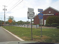 US 202 erroneously signed as a state route along CR 511 concurrency south of US 46 in Parsippany-Troy Hills
CR 511 begins at an intersection with CR 510 in Morris Township, Morris County, heading northeast on four-lane undivided Whippany Road. The route passes business parks before running between business parks to the northwest and homes to the southeast. The road widens into a divided highway and comes to the CR 650 intersection, where it forms the border between Hanover Township to the northwest and Morris Township to the southeast as it interchanges with the Route 24 freeway. CR 511 turns east into residential neighborhoods as an undivided road, becoming a divided highway again briefly as it comes to the CR 623 junction. At this point, the route fully enters Hanover Township and heads northeast past more homes, alternating between a four-lane divided and undivided road. CR 511 splits from Whippany Road by turning northwest onto two-lane Parsippany Road, with CR 622 continuing northeast along Whippany Road. The road turns north and passes over the Whippany River and crosses the Morristown and Erie Railway at-grade before intersecting CR 622 Alternate and coming to an interchange with Route 10. Past this interchange, the road runs through wooded neighborhoods before entering Parsippany-Troy Hills. At this point, CR 511 widens to four lanes and passes business parks, briefly widening into a divided highway. The route narrows into a two-lane undivided road as it interchanges with I-287 and passes through residential and commercial areas a short distance to the east of Lake Parsippany. CR 511 widens back to four lanes passes more business parks prior to coming to a bridge over I-80 and reaching an intersection with US 202 and CR 630, where CR 511 forms a concurrency with US 202.[1][2]
The two routes continue north on Parsippany Boulevard, a two-lane road that comes to an intersection with US 46, where the road is briefly state maintained. Past US 46, the road continues north, intersecting ramps that provide access to and from southbound I-287. Here, the road becomes county maintained again. It passes by business parks and then wooded residential areas, closely paralleling I-287 again.[1][2] At the intersection with Intervale Road, US 202 and CR 511 make a right turn, immediately interchanging with I-287, with access to the southbound direction and from the northbound direction. The routes follow Intervale Road briefly before making a left turn to resume onto Parsippany Boulevard.[1] The road crosses over the Jersey City Reservoir, which supplies drinking water to Jersey City, and enters Boonton, where the road becomes Washington Street. This street carries the two routes through residential areas before coming to another interchange with I-287 that also features access to the southbound direction and access from the northbound direction.[1] Past this interchange, US 202 splits from CR 511 by heading to the northeast on Myrtle Avenue.[1][2]
Past US 202, CR 511 continues northwest on Main Street and passes over New Jersey Transit's Montclair-Boonton Line near the Boonton Station before passing through the commercial downtown of Boonton. CR 511 splits from Main Street by turning northeast onto Boonton Avenue, with CR 624 continuing along Main Street. The road continues past homes before crossing into Boonton Township, where the route turns north into wooded mountain areas with some homes. The route continues north into Montville and turns northeast into less developed mountains, running to the east of the Taylortown Reservoir as it crosses into Kinnelon. In Kinnelon, CR 511 heads near wooded areas of residences, turning east near Fayson Lakes before winding north. The road enters Butler and reaches a junction with Route 23 in commercial areas. From here, the route continues past homes and some businesses, reaching the commercial downtown of Butler. In this area, CR 511 splits into a one-way pair, with the northbound direction turning east on Carey Avenue, north on Roberts Street, and west on High Street, and the southbound direction remaining on Boonton Avenue. At the north end of the one-way pair, the route intersects CR 618. After crossing the New York, Susquehanna and Western Railway, CR 511 turns east onto Main Street and passes more downtown businesses.[1][2]
Passaic County
Upon crossing the Pequannock River, CR 511 enters Bloomingdale in Passaic County and immediately intersects CR 694, becoming the Paterson-Hamburg Turnpike. The route passes homes and businesses in the downtown of Bloomingdale before CR 511 turns north onto Union Avenue, with CR 694 continuing east on the Paterson-Hamburg Turnpike. The road continues north past residential areas, heading northeast into more wooded areas with some homes. The route runs to the north of a lake and crosses into Wanaque, heading east into commercial areas and reaching ramps to and from the southbound lanes of I-287 prior to a junction with the northern terminus of CR 511 Alternate. At this point, CR 511 turns north onto Ringwood Avenue and passes a mix of residences and businesses. Farther north, the road passes more development as it runs a short distance to the east of the Wanaque Reservoir. The route heads into more wooded areas of development as it forms the border between Ringwood to the east and Wanaque to the west before completely entering Ringwood. In Ringwood, CR 511 enters dense mountain forests and winds along the eastern shore of the Wanaque Reservoir as Greenwood Lake Turnpike, intersecting Skyline Drive (CR 692) and CR 697. After the intersection with the latter, the road turns northwest and crosses over a few branches of the Wanaque Reservoir. The route curves north away from the reservoir and passes a few businesses as it comes to a junction with CR 698. From here, CR 511 turns northwest into more mountainous areas and enters West Milford, crossing the Wanaque River near the northern end of the Wanaque Reservoir. The road winds west through more rural areas with occasional homes and businesses before reaching the CR 696 intersection. Here, CR 511 makes a turn north and enters more dense commercial development as it comes to the intersection with the northern terminus of CR 513. The route passes more businesses as it begins to run along the western shore of Greenwood Lake, curving northwest prior to turning northeast and running through wooded residential areas along the lake. CR 511 continues along the lakeshore to the New York border, where the road continues into that state as NY 210.[1][2]
History
The northernmost part of present-day CR 511 near the New York border was legislated in the 1927 New Jersey state highway renumbering to be the northernmost part of Route 3.[3][4] In 1929, this segment of Route 3 was amended to be the northernmost part of Route S4B, a spur of Route 4. This part of road was never built as a state highway.[5]
Major intersections
County Location Mile[1] Destinations Notes Morris Morris Township 0.00 CR 510 (Whippany Road)Southern terminus 1.06 Route 24NJ 24 exit 1 Hanover Township 3.29 Route 10Interchange Parsippany-Troy Hills 5.16 I-287I-287 exit 40 6.30  US 202 south (Littleton Road)
South end of US 202 overlap 6.98 I-287 southAccess to southbound I-287, access from southbound I-287; I-287 exit 42 7.27  US 46
US 468.32 I-287Access to southbound I-287, access from northbound I-287; I-287 exit 43 Boonton 9.38 I-287Access to southbound I-287, access from northbound I-287; I-287 exit 44 9.39 US 202 north (Myrtle Avenue)North end of US 202 overlap Butler 17.11 Route 23Passaic Wanaque 21.01 I-287 southI-287 exit 55 21.13 
 CR 511 Alt. south (Ringwood Avenue)
West Milford 34.90 CR 513 south (Union Valley Road)37.44 NY 210 northNew York border, northern terminus 1.000 mi = 1.609 km; 1.000 km = 0.621 mi CR 511 Alternate

County Route 511 Alternate
Location: Wayne - Wanaque Length: 9.77 mi[6] (15.72 km) County Route 511 Alternate is an alternate route of CR 511. The highway extends 9.77 miles (15.72 kilometers) from the Boonton Turnpike (US 202) in Wayne to Union Avenue (CR 511) in Wanaque. The southern 2.58 miles (4.15 km) of this highway from the intersection of US 202 and NJ 23 in Wayne to the highway's split with US 202 in Lincoln Park are an example of a wrong-way concurrency, as northbound CR 511 ALT is concurrent with southbound US 202, and vice versa.
See also
 U.S. Roads portal
 New Jersey portal
References
- ^ a b c d e f g h i NJDOT County Route 511 straight-line diagram from the New Jersey Department of Transportation
- ^ a b c d e Google, Inc. Google Maps – overview of County Route 511 (Map). Cartography by Google, Inc. http://maps.google.com/maps?f=d&source=s_d&saddr=columbia+road+and+whippany+road&daddr=40.81779,-74.42065+to:40.83775,-74.42131+to:40.8688189,-74.4217188+to:40.88175,-74.42054+to:40.92591,-74.39956+to:41.0135777,-74.3164557+to:county+road+511+and+new+york+210&geocode=FbOAbgIdm9mP-ym97YSljqbDiTG7hVKi3TFvfg%3BFX7UbgIdVm6Q-ymJMyLnzKfDiTH58-czUpGZMQ%3BFXYibwIdwmuQ-yl3p7FuwqfDiTGFFDZF-HON7Q%3BFdKbbwIdKmqQ-ymJZZghEQjDiTF3ZRI8a983Og%3BFVbObwIdxG6Q-ylLCCeJbgjDiTFGiZqRaqpW8Q%3BFdZ6cAIduMCQ-ykL8deAAwbDiTHIcJ8MhFBNng%3BFUnRcQIdWQWS-ynZDWW2XhvDiTGxwmRIROqeWA%3BFU11dAIdhcyR-ynXCIW9OSLDiTGvkqEe7YuiXg&hl=en&mra=ls&via=1,2,3,4,5,6&sll=41.168058,-74.301739&sspn=0.058926,0.169086&ie=UTF8&t=h&z=10. Retrieved January 5, 2011.
- ^ State of New Jersey, Laws of 1927, Chapter 319.
- ^ Williams, Jimmy and Sharon. "1927 New Jersey Road Map". 1920s New Jersey Highways. http://www.jimmyandsharonwilliams.com/njroads/1920s/images/1927_routes.gif. Retrieved 2008-10-08.
- ^ State of New Jersey, Laws of 1929, Chapter 126.
- ^ NJDOT County Route 511 Alternate Straight Line Diagram from the New Jersey Department of Transportation
External links
Categories:- County routes in New Jersey
- Transportation in Morris County, New Jersey
- Transportation in Passaic County, New Jersey


Wikimedia Foundation. 2010.