- Mount Grace
-
This article is about a mountain in Massachusetts, USA. For the priory in England by the same name, see Mount Grace Priory.
Mount Grace 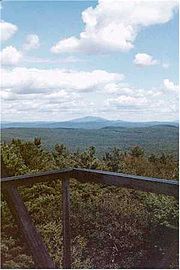
View from Mount Grace firetower; Mount Monadnock visible in the distanceElevation 1,617 ft (493 m) Location Location Warwick, Massachusetts. Range Upland plateau of central Massachusetts Coordinates 42°41′28″N 72°21′18″W / 42.69111°N 72.355°WCoordinates: 42°41′28″N 72°21′18″W / 42.69111°N 72.355°W Geology Type monadnock; metamorphic rock Age of rock 400 million yrs. Climbing Easiest route Metacomet-Monadnock Trail Mount Grace, 1,617 feet (493 m), is a prominent monadnock located in north central Massachusetts in the town of Warwick, approximately two miles south of the New Hampshire border. The mountain is rugged and largely wooded, but a firetower on the summit provides expansive views of the surrounding rural countryside. Little Mount Grace, 1,226 feet (374 m), is the southern summit of the mountain. Mount Grace supports a predominantly northern hardwood forest as well as stands of red spruce near its summit.[1]
The north side of Mount Grace drains into the Ashuelot River, thence into the Connecticut River, then Long Island Sound; the west side drains into the Connecticut River via Mill Brook; and the south and east sides drain into the Millers River, thence into the Connecticut River.[2]
Contents
History
Mount Grace is named after Grace (Sarah) Rowlandson, the daughter of Mary Rowlandson, a puritan colonist of Massachusetts. Grace died after she and her mother were captured by Native Americans of the Narragansett Tribe during King Phillip's War in 1676. She was reportedly buried at the foot of the mountain.[3]
Picnic Area
In the 1930s, the Civilian Conservation Corps built a picnic area on the west side of Route 78, at the bottom of the mountain, below the Gulch. The banks of the brook were walled with stone. The Corps also built a picnic area with stone fireplaces and grills, and road access to it. The hardwoods were thinned out, leaving only the White Pines.[citation needed]
In the 1980s, the State ceased maintaining the picnic area. Brush grew up. The area started the transition back to forest. By the late 1990s many of the big White Pines were dead. The State logged the area, and left the slash on the ground to help new trees grow.[citation needed]
Recreation and conservation
Mount Grace is located within the 1,458-acre (5.90 km2) Mount Grace State Forest. Hiking, backpacking, hunting, horseback riding, cross-country skiing, mountain biking, and snowshoeing are enjoyed on the mountain.[3] The 110-mile (180 km) Metacomet-Monadnock Trail traverses the summit. A lean-to on the east side of the mountain is available for primitive camping.[1]
In 2000, Mount Grace was included in a study by the National Park Service for possible inclusion in a new National Scenic Trail, now tentatively called the New England National Scenic Trail, which would include the Metacomet-Monadnock Trail in Massachusetts, and the Mattabesett and Metacomet trails in Connecticut.[4]
The Mount Grace Land Conservation Trust, active in the area, takes its name from Mount Grace.[5]
The Summit holds a small picnic area, and a state fire tower. Designated "Warwick Fire Tower," the roof was replaced along with the landing platforms and most of the stair treads in 2007. In spring of 2010, the interior of the fire tower was completely re-done and the rest of the stair treads replaced. It remains in service as an active state tower. It is staffed from March-May, and late August-October depending on the fire danger.
References
- ^ a b The Metacomet-Monadnock Trail Guide. 9th Edition. The Appalachian Mountain Club. Amherst, Massachusetts, 1999
- ^ DeLorme Topo 6.0 Mapping software. DeLorme, Yarmouth, Maine.
- ^ a b Massachusetts DCR Cited Dec. 12, 2007
- ^ Monadnock, Metacoment, Mattabesett National Scenic Trail Study. Cited Nov. 4, 2007.
- ^ Mount Grace Land Conservation Trust Cited Dec. 12, 2007
External links
- Massachusetts Department of Conservation and Recreation
- Mount Grace Land Conservation Trust
- Metacomet Monadnock Trail Berkshire Chaper of the Appalachian Mountain Club
Categories:- Mountains of Massachusetts
- Fire lookout towers in Massachusetts
- Landforms of Franklin County, Massachusetts
- Civilian Conservation Corps in Massachusetts

Wikimedia Foundation. 2010.