- Kirkintilloch
-
Coordinates: 55°56′08″N 4°09′17″W / 55.93568°N 4.15469°W
Kirkintilloch Scottish Gaelic: Cair Ceann Tulaich 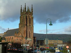
St Mary's Church in Kirkintilloch's Cowgate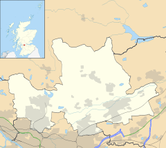
 Kirkintilloch
Kirkintilloch shown within East DunbartonshirePopulation 19,900 OS grid reference NS655735 Council area East Dunbartonshire Lieutenancy area Dunbartonshire Country Scotland Sovereign state United Kingdom Post town GLASGOW Postcode district G66 Dialling code 0141 Police Strathclyde Fire Strathclyde Ambulance Scottish EU Parliament Scotland UK Parliament East Dunbartonshire Cumbernauld, Kilsyth and Kirkintilloch East Scottish Parliament Strathkelvin and Bearsden West of Scotland List of places: UK • Scotland • Kirkintilloch (Scottish Gaelic: Cair Ceann Tulaich)[1] is a town and former burgh in East Dunbartonshire, Scotland. It lies on the Forth and Clyde Canal, about eight miles northeast of central Glasgow. The town is the administrative centre of the East Dunbartonshire council area, and its population in 2008 was estimated at 19,900.[2]
Contents
Toponymy
"Kirkintilloch" could be derived from "Caer-pen-tulach", a Celtic name (unusual for being an Old Welsh and Old Gaelic compound) translating as "Fort at the end of the hillock", or from the pure Gaelic "Càthair Cinn Tulaich". A possible reference to the site is made in the 9th century Welsh text Historia Brittonum, in which the Antonine Wall is said to terminate at 'Caerpentaloch'. The fort referred to is the former Roman settlement on the wall and the hillock is the volcanic drumlin which would have offered a strategic viewpoint for miles to the West, North and East.[3] The etymology is sometimes taken literally as "Kirk in tilloch" ("church in the field"). Its long name is often shortened by locals to the colloquial Kirkie or Kirky,[4] as reflected in a number of business names in the town.
History
The first known settlement on the site of what is now Kirkintilloch was of Roman origin, a fort established in what is now the Peel Park area of the town in the mid-2nd century, one of the northernmost posts in Roman Britannia. Through it the Antonine Wall was routed; its course continues through the centre of the town to this day, although little trace can now be seen above ground. There is no strong evidence of habitation on the site for the following thousand years until Clan Cumming established a castle (Motte and Bailey) and church there in the 12th century. A small settlement grew and was granted burgh status in 1211, becoming an important staging post for west-east journeys from Glasgow to eastern and north-eastern Scotland. From this time, a weekly market was held in the town, probably at the foot of Peel Brae (along with High Street and Cowgate, one of the three medieval thoroughfares in the town). The castle was of some importance during the wars of independence when an English garrison was stationed there, commanded by Sir Philip de Moubray, who was later to command Stirling Castle at the time of the Battle of Bannockburn. Soldiers from the castle were dispatched to arrest William Wallace at Robroyston in 1305 and escorted him to Dumbarton Castle. Later the same year, the garrison is recorded as having sent a petition to King Edward complaining of non-payment of wages. The castle was attacked by Scottish forces in 1306 under Bishop Wishart of Glasgow (using timber given to Glasgow diocese by the English for cathedral repairs), but the siege was unsuccessful. The castle is thought to have been destroyed on the orders of Robert Bruce later in the conflict, although the traces of a mot surrounded by a ditch can still be seen in the Peel Park.[5]
The original Cumming parish church, St Ninian's, was constructed around 1140 some distance to the east of the town (where some of the stones remain in the form of an 18th century watchtower at the entrance to the Auld Aisle Cemetery) as Kirkintilloch was originally in the parish of Lenzie which stretched from Cumbernauld in the East to Kirkintilloch in the West. The establishment was part of the endowment of Cambuskenneth Abbey, and was accompanied by a grant of one oxgang of land (approximately 15 acres), the measurement that lent its name to the area near the church. A chapel to the Virgin Mary was established in the town itself, sometime before 1379, and was endowed with land at Duntiblae by Sir David Fleming. The move of the parish church to the site of the chapel at Kirkintilloch Cross (now the Auld Kirk Museum) in 1644 resulted in a split of the Parish into Easter and Wester Lenzie (later Cumbernauld and Kirkintilloch Parishes) The name Lenzie was later reused for Kirkintilloch's railway station on the main Glasgow to Edinburgh line, around which the later village of that name developed.
Following the Scottish victory in the wars of independence and the subsequent decline of Clan Cumming, the baronies of Kirkintilloch, Lenzie, and Cumbernauld were granted by Robert Bruce to Sir Malcolm Fleming, Sheriff of Dumbarton and a supporter of the Bruce faction in the war. Hitherto part of Stirlingshire, the area subsequently became a detached part of the county of Dumbarton, in which it remains today.
On 3 January 1746, the retreating Jacobite army of Charles Stuart made its way through Kirkintilloch, on its way back from Derby, and on the march to Falkirk and ultimately Culloden. One of the Highland army's stragglers was shot dead at the town cross by a man hidden in a barn at the Kiln Close (where the library now stands). On hearing of the murder, Charles halted his army on the Kilsyth road and threatened to turn back and burn the town. The town magistrates persuaded him to continue marching, in return for an unspecified payment, and the town was spared.[6]
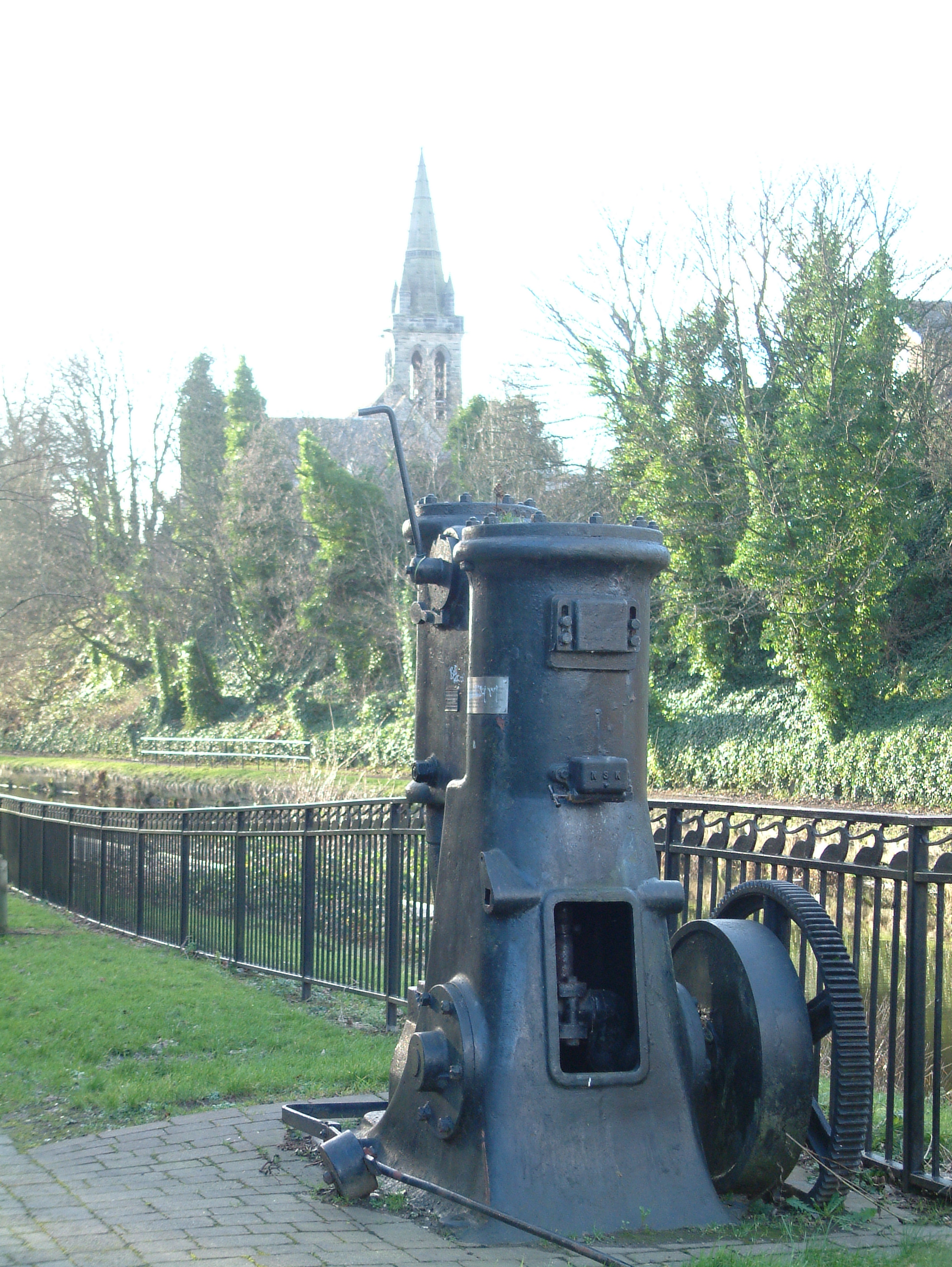
The town was one of the hotbeds of the industrial revolution in Scotland, beginning with the emergence of a booming textile industry in the area. There were 185 weavers in Kirkintilloch by 1790, and in 1867 James Slimon's cotton mill at Kelvinside employed 200 women.[7] With the construction of the Forth and Clyde Canal through the town in 1773, and the establishment of the Monkland and Kirkintilloch Railway in 1826, Kirkintilloch developed further as an important transportation hub, inland port, and production centre for iron, coal, nickel, and even small ships. This industrial heritage lives on in the town's designation as the "Canal Capital of Scotland", and in the redevelopment of the canal and surrounding former industrial sites in the early 21st century.
By the twentieth century, the principal employers in the town were the shipbuilders J & J Hay and Peter McGregor, and the Lion (1880-1884) and Star foundries, all of which produced goods for the domestic market and for export around the world.[7] Kirkintilloch's most famous exports were the distinctive red British postboxes and phoneboxes K2 to K6, produced in the town until 1984 and still to be found as far afield as Taiwan and Mississippi. Listed versions of these boxes still stand at the foot of Alexandra Street in the centre of Kirkintilloch.
Kirkintilloch was a "dry town" for much of its recent history, with the sale of alcohol on public premises banned from 1923 until 1967. The prohibition on the sale of alcohol had long been demanded by the Liberal Party and the temperance movement, both of which had a strong influence in the town in the early part of the 20th century, largely due to the perceived negative effects of alcohol on the town's inhabitants.
The 1960s development plan to redevelop inner city areas of Glasgow saw Kirkintilloch used as an overspill settlement for relocated Glaswegians in combination with the new towns of Livingston and Cumbernauld, offering employment in housebuilding and an increase to the local population to its current levels. Large numbers of new houses for owner occupation have been built since that time.[8]
Governance
Kirkintilloch and Lenzie had their own burgh council until the 1975 abolition of the counties of Scotland when it became part of the Strathkelvin local government district within the region of Strathclyde. A second reorganisation in 1996 established East Dunbartonshire council from Strathkelvin and the adjacent district of Bearsden and Milngavie; Kirkintilloch is its administrative centre and the council's headquarters are at Tom Johnston House in the town, named after prominent early 20th century politician and Kirkintilloch native, Thomas Johnston.
Geography

Milton of Campsie Bishopbriggs 
Twechar, Cumbernauld  Kirkintilloch

Stepps Communities in and around Kirkintilloch include: Cleddans; Harestanes; Hayston; Hillhead; Oxgang; Rosebank; Langmuir; Greens; Fauldhead; Waterside; Westermains; Lenzie: Gallowhill: Whitegates; Back O' Loch; Woodilee; Broomhill etc
Culture
Kirkintilloch Town Hall was opened in 1906, paid for by public subscription. Listed as a building of special architectural or historic interest, it was closed by East Dunbartonshire Council in June 2004, largely due to the anticipated expense of restoring a building constructed of notoriously crumbling soft sandstone. In response the Kirkintilloch Town Hall Preservation Trust was established as a registered charity to preserve the Hall and restore it for community use. By 2011 the only progress was the demolitoion of a small extension to the Town Hall and it remains a sorry sight in the centre of the town.
The town is served by the William Patrick Library, which relocated from a converted private villa near Peel Park to a new building on West High Street in the 1990s. The old library has reverted to private ownership. William Patricklibraryis the main library for East Dunbartonshire Council and also houses the reference department and other council offices..
Kirkintilloch underwent significant population growth in the post-World War II period, with several new amenities erected to cater for the growing population of the town and its surrounding villages. New shopping facilities were built in the Cowgate and Townhead areas, culminating in the opening, by the Princess of Wales, of the Regent Centre shopping mall in the 1990s.
The local swimming pool and Community Education Centre, built in the 1960s and 70s in Woodhead Park to the south of the town, were demolished in 1999 and 2005 respectively. Woodhead Park was once home to a petting zoo, bandstand, greenhouses, putting green and public toilets. All are now closed, although a new leisure centre was opened on the same spot in July 2007, providing facilities for tennis, badminton, swimming, football and a gymnasium. A large new children's play area has been created near the site of the former putting green in the park.
The construction of the new leisure centre comes in combination with a wider-ranging artistic, cultural and social regeneration project under way, called Kirkintilloch's Initiative.[9] This includes the new link road largely funded by housebuilders developing on the site of the former Woodilee Hospital.
Kirkintilloch Learning Centre is located on Southbank Road, overlooking the Forth and Clyde Canal, an offshoot of Cumbernauld College.
Locally, a G66+ Live! Cultural festival offers a wide range of events from talks on history in local churches to musical events in the town's local bars, such as Bar Bliss, dramas, and also entries from the schools in the G66 postcode area. G66+ Live! is annual festival taking place in June. Kirkintilloch's most successful musical ensemble is its brass band, the Kirkintilloch Band,[10] who were crowned Scottish Brass Band Champions in 2007 and who have had much success in competitions both in Scotland and further afield. Extremely popular is the annual (August) Canal Festival.
An amateur theatre group, the Kirkintilloch Players,[11] is based at the Turret Theatre in the Eastside area of Kirkintilloch, the former home of the town's Liberal Club.
The town has a variety of eateries, bars and nightspots. The Kirkie Puffer beat local rival bar The Antonine to pub of the year in January 2006 and this is an accolade that The Puffer has been able to win year after year. Local nightclubs Tantra (formerly Babylon) and Smiths Hotel (formerly Broadcroft Hotel) have been threatened with closure and have been forced into investing heavily in security and local alcohol awareness initiatives to help to discourage Anti Social Behaviour.
Kirkintilloch is twinned with the Iraqi city of Tikrit, which caused much furore amongst the Westminster bureaucrats, however a poll in the Kirkintilloch Herald revealed that many local residents backed the scheme, saying that it was good for international development and blossoming relations. No publicity is now given to the link and there is no reference on any road signs.
Media
The Kirkintilloch Herald[12] is the local newspaper of record, established by town businessman Donald MacLeod in premises on the Cowgate in 1883.
Recently Kirkintilloch has become the butt of many of comedian Frankie Boyle's jokes in his stand up tour. He cites Kirkintilloch as the worst place he has ever been. This notoriety has been of benefit to Kirkintilloch as Frankie Boyle himself recently held an impromptu stand up gig in local pub Bar Bliss. Further to this gig Frankie stated that "I think I would be doing Kirkie a disservice not to include them in my routine as the people here loved the gags". Boyle used his material on Kirkintilloch in the Glasgow Comedy Festival in March 2008.
Sport
The town has a small junior football club, Kirkintilloch Rob Roy F.C., thrice winners of the Scottish Junior Cup, who play at Adamslie Park in the west of the town, and is also home to the amateur Harestanes A.F.C., twice winners of the Scottish Amateur Cup.
A replacement swimming pool and gym opened in July 2007 at Woodhead Park. The town is also home to "The Kirkintilloch Olympians", a local athletics club of some repute.
Kirkintilloch is also the home of Rangers star Gregg Wylde.[13]
Churches
There are a number of churches in Kirkintilloch. The four Church of Scotland congregations are: St Mary's, St David's Memorial Park, St Columba's and Hillhead. The Baptist Union of Scotland has churches at Townhead [14][15] and Harestanes. There are two Roman Catholic Churches - St Flannan's in Hillhead, and Holy Family and St Ninian's in the town centre.
Photogallery
See also
References
- ^ Gaelic Place-Names of Scotland
- ^ http://www.scotland.gov.uk/Publications/2011/09/26153917/5
- ^ The name Kirkintilloch « Senchus
- ^ Queue must be having a laugh – Kirky’s cut off! - Local Headlines - Kirkintilloch Herald
- ^ Time Team invited to unearth Kirky's medieval secrets - Local Headlines - Kirkintilloch Herald
- ^ Kirkintilloch, town and parish - Thomas Watson - Google Book
- ^ a b The rich history of Kirkintilloch - s1Kirkintilloch
- ^ [1][dead link]
- ^ http://www.k-eye.co.uk
- ^ Untitled Document
- ^ Home of Kirkintilloch Players Amateur Drama Club
- ^ Kirkintilloch Herald
- ^ Ibrox winger is still Wylde about Rangers! - Football - Kirkintilloch Herald
- ^ [2][dead link]
- ^ Kirkintilloch Baptist Church
Bibliography
- Old Glasgow and It's Suburbs in their Celtic Gard: Also Parish of Baldernock - Kirkintilloch to Stirling - Robroyston by Neil Thomson with 80 pages. From a copy of Old Glasgow published by Coghill in 1907 with no ISBN
External links
- East Dunbartonshire Council
- Kirkintilloch Herald, the local newspaper.
- G66 Festival
- http://www.kirkintillochcanalfestival.org/ ,
- National Library of Scotland: SCOTTISH SCREEN ARCHIVE (selection of archive films about Kirkintilloch)
Categories:- Towns in East Dunbartonshire
-


Wikimedia Foundation. 2010.