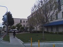
Downtown Richmond, Richmond, California
- Downtown Richmond, Richmond, California
-
Downtown Richmond is the old center of Richmond, California. The area is roughly bordered by 6th street to the west, 23rd Street to the east, Barrett Avenue to the north, and Macdonald Avenue to the south. The area once featured major department stores and other chains such as J.C. Penney, S. H. Kress & Co., and Sears before Hilltop Mall was built in the 1970s. The area is currently undergoing a revitalization effort by the city, which has included the Richmond Shopping Center anchored by a supermarket. The Richmond Transit Village—coined Metro Walk by the developers, the Olson Company—has also been built, along with remodeling of the Richmond BART and Amtrak station and a bus transit center served by AC Transit and Golden Gate Transit. A Kaiser Permanente hospital and a Social Security Administration processing center provide for a majority of the jobs in the area.
37°56′16″N 122°21′19″W / 37.93767°N 122.35525°W / 37.93767; -122.35525
Categories: - Richmond, California
- Neighborhoods in Richmond, California
- Contra Costa County, California geography stubs
Wikimedia Foundation.
2010.
Look at other dictionaries:
Richmond Heights, Richmond, California — For the adjacent unincorporated area, see East Richmond Heights, California. Richmond Heights in 1912. Richmond Heights formerly East Richmond and also known as Richmond View and Mira Vista is a district of eastern Richmond, California in the San … Wikipedia
Richmond, California — Infobox Settlement official name = City of Richmond, California motto = The City of Pride and Purpose image seal size = 162 mapsize = map caption = subdivision type = Country subdivision name = United States subdivision type1 = State subdivision… … Wikipedia
Richmond, California municipal elections, 2006 — The Richmond, California 2006 city election decided the mayor, four council members, and one measure submitted to the voters of Richmond, California on November 7, 2007.[1] The election also elected the first Green Party mayor of this city, and… … Wikipedia
Marina Bay, Richmond, California — For other places with the same name, see Marina Bay (disambiguation). Marina Bay Neighborhood of Richmond … Wikipedia
Atchison Village, Richmond, California — Atchison Village is a community in Richmond, California which was originally built as housing for defense workers from the Kaiser Shipyards. Constructed by the Richmond Housing Authority in 1941 as Richmond s first public defense housing project … Wikipedia
Point Richmond, Richmond, California — Point Richmond or simply The Point is a neighborhood in southwestern Richmond, California near the eastern end of the Richmond San Rafael Bridge, between Interstate 580 and the San Francisco Bay. Its compact size and many historic buildings give… … Wikipedia
23rd Street (Richmond, California) — 23rd Street is a major north south trunk street in Richmond and San Pablo, California flanked by many Latino oriented businesses.[1][2] History The street runs between San Pablo Avenue in the north and Interstate 580 in the south after which it… … Wikipedia
North & East, Richmond, California — Corner of Macdonald and San Pablo Avenues on the southern end of the sector. North East as it is officially designated, but better known as Central Richmond is a neighborhood on the eastern side of Richmond, California. Contents 1 … Wikipedia
Iron Triangle, Richmond, California — The Iron Triangle, sometimes known as South Richmond, is a neighborhood in Richmond, California. It is a largely residential area but includes the downtown Richmond business district along Macdonald Avenue. Commercial areas on Cutting Boulevard… … Wikipedia
Parchester Village, Richmond, California — Parchester Village is a master planned neighborhood in Northwestern Richmond, California.Parchester Village was originally planned as the first interracial residential development, but was designated all black after whites lost interest in… … Wikipedia

