- Odanak, Quebec
-
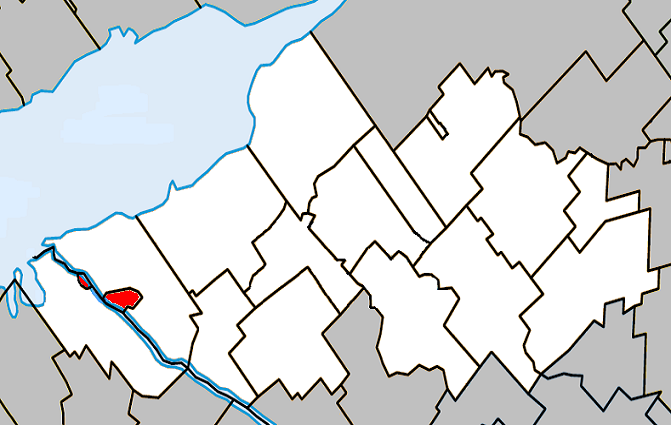
Odanak (Quebec) — Indian Reserve —  Location within Nicolet-Yamaska Regional County Municipality.
Coordinates: 46°04′23″N 72°48′37″W / 46.07306°N 72.81028°W Country  Canada
Province  Quebec
Region Centre-du-Québec RCM Nicolet-Yamaska
Within RCM, but unassociatedElectoral Districts
Federal
Bas-Richelieu—Nicolet—BécancourProvincial Nicolet-Yamaska Government[1][2][3] – Type Band council – Federal MP(s) Louis Plamondon (BQ) – Quebec MNA(s) Jean-Martin Aussant (PQ) Area[4] – Land 5.70 km2 (2.2 sq mi) Population (2006)[4] – Total 469 – Density 82.3/km2 (213.2/sq mi) – Change (2001-06) 10.4% – Dwellings 204 Time zone EST (UTC-5) – Summer (DST) EDT (UTC-4) Area code(s) 450 Access Routes[5]  Route 132
 Route 226
Odanak is an Indian reserve in the Centre-du-Québec region, Quebec, Canada. The mostly Abenaki population as of the Canada 2006 Census was 469. The territory is located near the mouth of the Saint-François River at its confluence with the St. Lawrence River. It is partly within the limits of Pierreville and across the river from Saint-François-du-Lac. Odanak is an Abenaki word meaning "in the village".
Contents
History
Beginning about 1000 CE, Iroquoian-speaking people settled along the St. Lawrence River, where they practiced agriculture along with hunting and fishing. Archeological surveys have revealed that by 1300, they built fortified villages identifiable as similar to those seen and described by French explorer Jacques Cartier in the mid-16th century, when he visited Hochelaga and Stadacona. By 1600, however, the villages and people were gone. Since the 1950s, historians and anthropologists have used archeological and linguistic evidence to develop a consensus that the people formed a distinct group, which they have called St. Lawrence Iroquoians. They spoke Laurentian and were separate from the powerful Iroquois confederacy of nations that developed in present-day New York.[6]
Their disappearance by 1600 is believed to be due to attacks and decimation from the Mohawk Nation, which stood to gain the most by getting control of the hunting grounds along the St. Lawrence River and dominating the fur trade route above Tadoussac, which was under Montagnais control. By the time of Samuel de Champlain's arrival, the St. Lawrence River valley was essentially uninhabited and used by the Mohawk only for hunting grounds and as a path for war parties.[7]
As French missionaries worked in present-day Quebec and central-western New York with native peoples in the late 17th and early 18th century, they established mission villages for converted natives near the colonial towns of Quebec City and Montreal. The Abenaki who converted to Catholicism were allied with the French. There is evidence that St. Francis was first occupied by the Sokokis as early as 1660 according to tradition, as many as twenty families; the earliest Sokoki baptism recorded in the area was nearby in Trois-Rivières in 1658. Central Maine was formerly inhabited by people of the Androscoggin tribe, also known as Arosaguntacook. The Androscoggins were a tribe in the Abenaki nation. They were driven out of the area in 1690 sometime after King Philip's War (1675-1676). They were relocated at St. Francis, Canada, which was later destroyed and burnt by Rogers' Rangers in 1759. The Abenakis and some St. Francis residents participated in raids, which were sometimes organized and led by French military men, against English colonial settlements on the frontiers of New England in the late 17th and early 18th centuries. Other Abenaki tribes suffered several severe defeats in reprisal, particularly the capture of Norridgewock in 1724 and the defeat of the Pequawket in 1725, which greatly reduced their numbers. They finally withdrew to Canada, where they were settled at Bécancour and Sillery, and later at St. Francis, along with other refugee tribes from the south.[8]
Contemporary
Odanak is the site of the Musée des Abénakis (Abenaki Museum), dedicated to the history, culture and art of the Western Abenaki people. The reserve supports several other businesses, including an independently owned gas station and a dairy specializing in the production of cheese ("La Fromagerie d'Odanak").
Aboriginal award-winning filmmaker Alanis Obomsawin grew up in Odanak. Her domumentary, Waban-Aki: People from Where the Sun Rises[9] (2006) is a tribute to the people of St. Francis. Her most recent documentary film Gene Boy Came Home (2007) tells the story of Eugene "Gene Boy" Benedict. He was raised in Odanak. As a young man, he fought in the US Marine Corps against the North Vietnamese in the Vietnam War before returning to his roots and home village.
Demographics
Population
Population trend[10]
Census Population Change (%) 2006 469  10.4%
10.4%2001 425 8.4%1996 392 17.7%1991 333 N/A Language
Mother tongue language (2006)[4]
Language Population Pct (%) French only 410 88.17% English only 55 11.83% Both English and French 0 0.00% Other languages 0 0.00% See also
References
- ^ Ministère des Affaires Municipales et Régions: Odanak
- ^ Parliament of Canada Federal Riding History: BAS-RICHELIEU--NICOLET--BÉCANCOUR (Quebec)
- ^ Chief Electoral Officer of Québec - 40th General Election Riding Results: NICOLET-YAMASKA
- ^ a b c 2006 Statistics Canada Community Profile: Kahnawake
- ^ Official Transport Quebec Road Map
- ^ James F. Pendergast. (1998). "The Confusing Identities Attributed to Stadacona and Hochelaga", Journal of Canadian Studies, Volume 32, pp. 149-156, accessed 3 Feb 2010
- ^ James F. Pendergast. (1998). "The Confusing Identities Attributed to Stadacona and Hochelaga", Journal of Canadian Studies, Volume 32, pp. 149-156, accessed 3 Feb 2010
- ^ Bruce G. Trigger (ed.): Handbook of North American Indians. Vol. 15. Northeast. Smithsonian Institution Press, Washington D.C. 1978 ISBN 0-16004-575-4
- ^ National Film Board of Canada
- ^ Statistics Canada: 1996, 2001, 2006 census
External links

Saint-François-du-Lac 
Pierreville  Odanak
 Administrative divisions of Centre-du-Québec (Region 17)
Regional county municipalities
and equivalent territoriesMunicipalities Princeville · Plessisville (V) · Bécancour · Victoriaville · Warwick · Kingsey Falls · Daveluyville · Drummondville · Nicolet
Categories:- First Nations reserves in Quebec
- Communities in Centre-du-Québec
- Abenaki communities
Wikimedia Foundation. 2010.