- Pierreville, Quebec
-
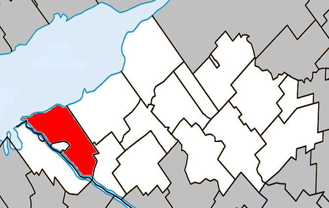
Pierreville, Quebec — Municipality — Location within Nicolet-Yamaska Regional County Municipality.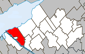
Coordinates (26, rue Ally [1]): 46°04′03″N 72°48′50″W / 46.0675°N 72.81389°W Country  Canada
Province  Quebec
Region Centre-du-Québec RCM Nicolet-Yamaska Municipality June 13, 2001 Electoral Districts
Federal
Bas-Richelieu—Nicolet—BécancourProvincial Nicolet-Yamaska Government[1][2][3] – Mayor André Descôteaux – Federal MP(s) Louis Plamondon (BQ) – Quebec MNA(s) Jean-Martin Aussant (PQ) Area[4] – Land 78.31 km2 (30.2 sq mi) Population (2006)[4] – Total 2,337 – Density 29.8/km2 (77.2/sq mi) – Change (2001-06)  2.7%
2.7%– Dwellings 1,174 Time zone EST (UTC-5) – Summer (DST) EDT (UTC-4) Postal code(s) J0G Area code(s) 450 Access Routes[5]  Route 132
 Route 226
Pierreville is a community in Nicolet-Yamaska Regional County Municipality, Quebec, located at the confluence of the Saint Lawrence and Saint-François rivers, at the edge of Lac Saint-Pierre. The population as of the Canada 2006 Census was 2,337.
Pierreville faces the town of Saint-François-du-Lac across the Saint-François river, and lies at the junction of Route 132 and Route 226. Part of the Abenaki Indian reserve of Odanak is an enclave within the city limits of Pierreville. The limits of the reserve begin only a short walk away from the town's main street.
Contents
Demographics
Population
Population trend[6]
Census Population Change (%) 2006 2,337 2.7%Merger (+) 2,402  60.4%
60.4%2001 950 10.0%Boundary change 1,055 7.5%1996 976 9.1%1991 1,074 N/A (+) Amalgamation of the Parishes of Notre-Dame-de-Pierreville, Saint-Thomas-de-Pierreville, and the Village of Pierreville on June 13, 2001.
Language
Mother tongue language (2006)[4]
Language Population Pct (%) French only 2,235 97.60% English only 10 0.44% Both English and French 0 0.00% Other languages 45 1.96% Climate
Climate data for Pierreville Month Jan Feb Mar Apr May Jun Jul Aug Sep Oct Nov Dec Year Record high °C (°F) 14.5
(58.1)11.5
(52.7)16.5
(61.7)31.5
(88.7)31
(88)34
(93)34
(93)33.5
(92.3)31.5
(88.7)25.5
(77.9)21
(70)14.5
(58.1)34
(93)Average high °C (°F) −6.5
(20.3)−4.1
(24.6)1.4
(34.5)10.3
(50.5)18.7
(65.7)23.6
(74.5)25.8
(78.4)24.6
(76.3)19.3
(66.7)12.3
(54.1)4.3
(39.7)−2.9
(26.8)10.6 Daily mean °C (°F) −11.6
(11.1)−9.3
(15.3)−3.5
(25.7)5.4
(41.7)12.9
(55.2)18
(64)20.3
(68.5)19.1
(66.4)14.2
(57.6)7.8
(46.0)0.8
(33.4)−7.2
(19.0)5.6 Average low °C (°F) −16.6
(2.1)−14.4
(6.1)−8.3
(17.1)0.5
(32.9)7.2
(45.0)12.4
(54.3)14.7
(58.5)13.7
(56.7)9
(48)3.3
(37.9)−2.8
(27.0)−11.4
(11.5)0.6 Record low °C (°F) −38
(−36)−34
(−29)−32
(−26)−15
(5)−3
(27)0
(32)4.5
(40.1)2
(36)−3
(27)−7
(19)−20
(−4)−37.5
(−35.5)−38
(−36)Precipitation mm (inches) 76.7
(3.02)57
(2.24)64.8
(2.551)73.5
(2.894)87.1
(3.429)91.1
(3.587)97.4
(3.835)94.7
(3.728)79.2
(3.118)81
(3.19)95.4
(3.756)69.5
(2.736)967.5
(38.091)Source: Environment Canada[7] See also
References
- ^ a b Ministère des Affaires Municipales et Régions: Pierreville
- ^ Parliament of Canada Federal Riding History: BAS-RICHELIEU--NICOLET--BÉCANCOUR (Quebec)
- ^ Chief Electoral Officer of Québec - 40th General Election Riding Results: NICOLET-YAMASKA
- ^ a b c 2006 Statistics Canada Community Profile: Pierreville, Quebec
- ^ Official Transport Quebec Road Map
- ^ Statistics Canada: 1996, 2001, 2006 census
- ^ Environment Canada Canadian Climate Normals 1971–2000, accessed 23 July 2010

Lac Saint-Pierre Saint-François River /
Odanak / Saint-François-du-Lac
Baie-du-Febvre  Pierreville

Saint-Elphège Administrative divisions of Centre-du-Québec (Region 17)Regional county municipalities
and equivalent territoriesMunicipalities Princeville · Plessisville (V) · Bécancour · Victoriaville · Warwick · Kingsey Falls · Daveluyville · Drummondville · Nicolet
Categories:- Municipalities in Quebec
- Incorporated places in Centre-du-Québec
- Populated places on the Saint Lawrence River
Wikimedia Foundation. 2010.