- Cricqueville-en-Bessin
-
Cricqueville-en-Bessin
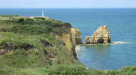
La Pointe du Hoc 
 Cricqueville-en-BessinLocation within Lower Normandy region
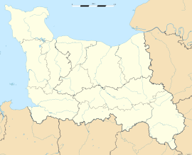 Cricqueville-en-Bessin
Administration Country France Region Lower Normandy Department Calvados Arrondissement Bayeux Canton Isigny-sur-Mer Intercommunality Isigny Grandcamp Mayor Frédéric Pain
(2008–2014)Statistics Elevation 0–39 m (0–128 ft)
(avg. 50 m/160 ft)Land area1 8.55 km2 (3.30 sq mi) Population2 186 (2008) - Density 22 /km2 (57 /sq mi) INSEE/Postal code 14204/ 14450 1 French Land Register data, which excludes lakes, ponds, glaciers > 1 km² (0.386 sq mi or 247 acres) and river estuaries. 2 Population without double counting: residents of multiple communes (e.g., students and military personnel) only counted once. Coordinates: 49°22′38″N 1°00′01″W / 49.37712°N 1.00019°W
Cricqueville-en-Bessin is a commune in the Calvados department in the Basse-Normandie region in northwestern France.
The municipality takes its name from its deep-water creek that forms a natural harbor, from Crycavilla.
Contents
History
World War II
Just outside of Cricqueville, the United States Army Air Force established an airfield shortly after D-Day on 9 June 1944, just three days after the Allied landings in France. The airfield was one of the first established in the liberated area of Normandy. Known as Advanced Landing Ground "A-2" (Cricqueville), it was used from early June though September 1944. After the Americans moved east into Central France, the airfield was dismantled and the land returned to agricultural use.[1][2]
Population
Historical population of Cricqueville-en-Bessin 1962 1968 1975 1982 1990 1999 2008 197 200 190 157 171 182 186 See also
- Communes of the Calvados department
- Pointe du Hoc, a point of attack by the United States Army during the Battle of Normandy
References
Categories:- Communes of Calvados
- Calvados geography stubs


Wikimedia Foundation. 2010.