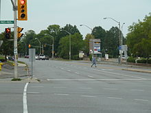
- Meadowlands Drive
-
 The end of Meadowlands Drive at Prince of Wales Drive
Meadowlands Drive (Ottawa Road #51) is a suburban road in Ottawa, Ontario, Canada. It begins at Prince of Wales Drive as a continuation of Hog's Back Road in the neighborhood of Rideauview. There are two small shopping plazas and a Shell station at its corner with Prince of Wales. It then continues westward towards Fisher Avenue and consists of low-income housing projects, low-rise apartment buildings, townhouses and semi-detached homes. The speed limit here is 50 km/h (31 mph) and there are two lanes in each direction.
West of Fisher Avenue, the speed limit decreases to 40 km/h (25 mph), there is only one lane in each direction and there are more low-rise apartment buildings and townhouses and as single family homes as well as a park. Just east of its intersection with Merivale Road, there is a cluster of high-rise apartment buildings and two schools. The road then quickly widens to two lanes in each direction for its busy intersection with Merivale Road. This intersection is a major shopping area, consisting of four shopping plazas, one on each corner, and includes many stores, including Zellers, a Mexx outlet, HMV, Home Outfitters, Winners, and Staples. There are also several restaurants here, including Wendy's, Tim Hortons, Swiss Chalet and Mr. Sub.
West of Merivale Road, the road quickly reverts to 2 lanes in each direction at 40 km/h and is residential with the exception of a public school, a Montessori school and St Maurice Catholic Church. It ends at Woodroffe Avenue and becomes Tallwood Drive west of Woodroffe.
Due to the order in which the neighbourhoods along Meadowlands Drive were built, the numbering is not consistent. Addresses up to 178 are in the section west of Merivale Road (intermittently signed Meadowlands Dr. W.), while addresses from 888 up are east of Merivale Road, beginning at Prince of Wales Drive.
Many university and college students live along Meadowlands Drive during the school year because of its proximity and bus links to Algonquin College and Carleton University.
Bus routes
Meadowlands Drive is well served by OC Transpo bus service as follows:
- Route 3 travels between Prince of Wales and Fisher.
- Route 86 travels between Fisher and Woodroffe.
- Route 111 travels between Prince of Wales and Merivale and again between Viewmount and Woodroffe.
- Route 156 travels between Chesterton and Merivale
- Route 57 travels, in peak hours only, between Fisher and Chesterton and again between Viewmount and Woodroffe.
- Route 117 travels the entire length of the road
- Route 116 travels between Woodroffe and Merivale
Neighbourhoods
Meadowlands Drive generally passes through the following neighbourhoods.
- Rideau View
- Carleton Heights
- Fisher Heights
- Parkwood Hills
- Borden Farm
Major Intersections
- Prince of Wales Drive
- Fisher Avenue
- Merivale Road
- Woodroffe Avenue
Roads in Ottawa Provincial Highways Major Arteries 4th Line · Tenth Line · Airport · Albion · Bank · Baseline · Blair · Bronson · Carling · Carp · Cedarview · Conroy · Donnelly · Dwyer Hill · Eagleson · Elgin · Fallowfield · Greenbank · Hazeldean · Heron · Hunt Club · Innes · King Edward · March · Merivale · Mitch Owens · Moodie · Montreal · Parkdale · Prince of Wales · Regional Road 174 · Richmond · Rideau · River · Riverside · Robertson · St. Joseph · St. Laurent · Strandherd · Terry Fox · Vanier · Walkley · Wellington · WoodroffeCollectors/Secondary Arteries Albert · Alta Vista · Bankfield · Beechwood · Booth · Brookfield · Gladstone · Hawthorne · Hog's Back · Jockvale · Katimavik · Kent · Laurier · Lees · Leitrim · Main · Maitland · Meadowlands · Metcalfe · Nicholas · North Gower · O'Connor · Old Prescott · Osgoode Main · Pinecrest · Preston · Russell · Slater · Smyth · Somerset · Sparks · St. Patrick · Sussex · Tremblay · TrimFederal arteries Roads in Ontario Categories:- Roads in Ottawa
Wikimedia Foundation. 2010.
