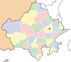
- Deoli, Rajasthan
-
Deoli — city — Coordinates 25°45′00″N 75°23′00″E / 25.75°N 75.3833°ECoordinates: 25°45′00″N 75°23′00″E / 25.75°N 75.3833°E Country India State Rajasthan District(s) Tonk Population 20,023 (2001[update]) Time zone IST (UTC+05:30) Area
• 296 metres (971 ft)
Deoli is a city and a municipality in Tonk district, 85 km away from Kota in the state of Rajasthan, India.
Demographics
As of 2007[update] India census[1], Deoli had a population of 30,023. Males constitute 54% of the population and females 46%. Deoli has an average literacy rate of 79%, higher than the national average of 59.5%: male literacy is 77% and female literacy is 61%. In Deoli, 10% of the population is under 6 years of age. deoli was established as British Chavni around 1850s. It was one of the 6 British Chavnis in rajasthan. During the 1857 revolt tatiya tope came here. It is situated at NH12. The best part about deoli is, being such a small place it has kendriya vidhyalaya. It has 2 undergraduate colleges and no post graduation college as on now.
References
- ^ "Census of India 2001: Data from the 2001 Census, including cities, villages and towns (Provisional)". Census Commission of India. Archived from the original on 2004-06-16. http://web.archive.org/web/20040616075334/http://www.censusindia.net/results/town.php?stad=A&state5=999. Retrieved 2008-11-01.
Tonk Deoli · Malpura · Niwai · Todaraisingh · Tonk · Uniara · Vanasthali · Dev Dham Jodhpuriya · Manoharpura. Kacholiya
Cities and towns
in other districtsAjmer · Alwar · Banswara · Baran · Barmer · Bharatpur · Bhilwara · Bikaner · Bundi · Chittorgarh · Churu · Dausa · Dholpur · Dungarpur · Hanumangarh · Jaipur · Jaisalmer · Jalore · Jhalawar · Jhunjhunu · Jodhpur · Karauli · Kota · Nagaur · Pali · Pratapgarh · Rajsamand · Sawai Madhopur · Sikar · Sirohi · Sri Ganganagar · Udaipur
Categories:- Cities and towns in Tonk district
- Rajasthan geography stubs
Wikimedia Foundation. 2010.


