- Mahaicony
-
Mahaicony The newly constructed Mahaicony Bridge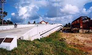 Location in Guyana
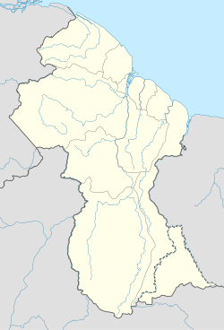
 Mahaicony
Coordinates: 6°33′N 57°48′W / 6.55°N 57.8°WCoordinates: 6°33′N 57°48′W / 6.55°N 57.8°W Country  Guyana
Region Mahaica-Berbice Population - Total 2,000 Mahaicony is a village in the Mahaica-Berbice Region of Guyana, located at 06°33′N 57°48′W / 6.55°N 57.8°W. In other words, Mahaicony's boundary on the coast is from De Hoop on the west and Calcutta on the east.
Economic Activity Fishing, farming and hunting are three of the oldest economic activities known to man. In Mahaicony these are still the most popular way of life for the residents. The area produces over 15,000 metric tons of paddy each year.
The activities of the community are usually affected by flooding during the rainy season and the drying up of ponds during the dry season.
Education
There is a Secondary School named Mahaicony Secondary School. However Novar, a nearby village also has a school that provides secondary education, but it is not a Secondary School. Over crowded classrooms is one of several problems faced by both teachers and students of Mahaicony Secondary School. Despite these limitations, Mahaicony Secondary School has been achieving high percentage passes in all subject areas.
in the surrounding area Primary schools are scattered around from Mahaicony, Zeeland in the west to Calcutta in the east to Mora Point in the deep south. Access to primary education is not a problem but the culture of the community is that teens take the agricultural fields at an early age, hence, fewer attend secondary school. The general conception is that somebody has to do the farming.
Health Care
The Government of Guyana has recently renovated the District Hospital. Along with the renovation came an upgrade of the equipments and other facilities at the hospital. Many people welcome the upgrade and would like that the GoG upkeep the current state of the hospital and further improving it. However, more nurses are needed.
There are several health centers across the area. Access to basic healthcare is not a problem.
Settlements in GuyanaFor the definition of city, town, etc see Settlements in Guyana. Cities Towns Albion · Anna Regina · Bartica · Corriverton · Fort Wellington · Ituni · Lethem · Linden · Mabaruma · Mahaica · Mahaicony · New Amsterdam · Paradise · Rosignol · Skeldon · Vreed en HoopVillages Adventure · Aishalton · Annai · Arimu Mine · Belfield · Beterverwagting · Better Hope · Biloku · Blairmont · Burma · Buxton · Campbelltown · Cane Grove · Charity · Clonbrook · Crabwood Creek · El Paso · Enmore · Enterprise · Esau and Jacob · Everton · Fort Washington · Good Hope · Governor Light · Hackney · Helena · Holmia · Hope · Hosororo · Hyde Park · Imbaimadai · Isherton · Issano · Isseneru · Jonestown · Kabakaburi · Kalkuni · Kamarang · Kamikusa · Kamwatta Hill · Kangaruma · Kartabo · Kartuni · Keweigek · Koriabo · Kumaka, Barima-Waini · Kumaka, East Berbice-Corentyne · Kuru Kuru · Kurupakari · Kurupung · Kwakwani · Kwebanna · Leonora · Long Creek · Lusignan · Mahdia · Maicobi · Makouria · Mara · Matthew's Ridge · Meten-Meer-Zorg · Moleson Creek · Mora Point · Morawhanna · Moruca · New Found Out · Nonpareil · Orealla · Orinduik · Paramakatoi · Parika · Peters Mine · Pickersgill · Port Kaituma · Port Mourant · Potaro Landing · Princeville · Providence · Rockstone · Rose Hall · Santa Rosa · Saveretik · Saxacalli · Schoon Ord · Seweyo · Silver Hill · Spring Garden · St. Monica Karawab · Suddie · Surama · Takama · Three Friends · Timehri · Towakaima · Tumatumari Landing · Tumatumari · Tumereng · Uitvlugt · Unity Village · Victoria · Wakapau · Wandaik · Wel te Vreeden · Weldaad · Wichabai · Wowetta · Zeeburg · ZeelandiaCommunities Estates Catherinas Lust · Dadanawa RanchMissions Neighbourhoods GeorgetownCategories:- Populated places in Guyana
- Mahaica-Berbice
- Guyana geography stubs


Wikimedia Foundation. 2010.