- Georgetown, Guyana
Infobox Settlement
official_name = Georgetown, Guyana
other_name =
native_name =
nickname = Garden city
settlement_type =
motto =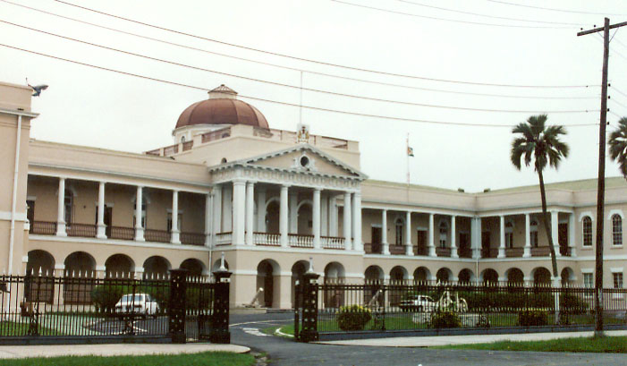
imagesize = 300px
image_caption = Parliament Building, Georgetown
flag_size =
image_
seal_size =
image_shield =
shield_size =
image_blank_emblem =
blank_emblem_type =
blank_emblem_size =
mapsize =
map_caption =
mapsize1 =
map_caption1 =
image_dot_
dot_mapsize =
dot_map_caption =
dot_x = |dot_y =
pushpin_
pushpin_label_position =bottom
pushpin_map_caption =Location in Guyana
subdivision_type = Country
subdivision_name =
subdivision_type1 = Admin. division
subdivision_name1 =Demerara-Mahaica
subdivision_type2 =
subdivision_name2 =
subdivision_type3 =
subdivision_name3 =
subdivision_type4 =
subdivision_name4 =
government_footnotes =
government_type =
leader_title =
leader_name =
leader_title1 =
leader_name1 =
leader_title2 =
leader_name2 =
leader_title3 =
leader_name3 =
leader_title4 =
leader_name4 =
established_title =
established_date =
established_title2 =
established_date2 =
established_title3 =
established_date3 =
area_magnitude =
unit_pref =Imperial
area_footnotes =
area_total_km2 =
area_land_km2 =
area_water_km2 =
area_total_sq_mi =
area_land_sq_mi =
area_water_sq_mi =
area_water_percent =
area_urban_km2 =
area_urban_sq_mi =
area_metro_km2 =
area_metro_sq_mi =
area_blank1_title =
area_blank1_km2 =
area_blank1_sq_mi =
population_as_of =2002
population_footnotes =
population_note =
population_total =310,320
population_density_km2 =
population_density_sq_mi =
population_metro =
population_density_metro_km2 =
population_density_metro_sq_mi =
population_urban =
population_density_urban_km2 =
population_density_urban_sq_mi =
population_blank1_title =Ethnicities
population_blank1 =
population_blank2_title =Religions
population_blank2 =
population_density_blank1_km2 =
population_density_blank1_sq_mi =
timezone =
utc_offset =
timezone_DST =
utc_offset_DST =
latd=6 |latm=48 |lats= |latNS=N
longd=58|longm=10 |longs= |longEW=W
elevation_footnotes =
elevation_m =
elevation_ft =
postal_code_type =
postal_code =
area_code =
blank_name =
blank_info =
blank1_name =
blank1_info =
website =
footnotes =Georgetown, estimated population 310,320 (2002 Guyana census), is the
capital and largest city ofGuyana , located in theDemerara-Mahaica region. It is situated on theAtlantic Ocean coast at the mouth of theDemerara River and it was nicknamed 'Garden City of the Caribbean.' Georgetown is located at coord|6|48|N|58|10|W|. The city serves primarily as a retail and administrative centre. It also serves as a financial services centre.History
The city of Georgetown began as a small town in the 18th century. Originally, the capital of the
Demerara-Essequibo colony was located onBorselen Island in the Demerara River under the administration of the Dutch. When the colony was captured by the British in 1781, Lieutenant-ColonelRobert Kingston chose the mouth of the Demerara River for the establishment of a town which was situated between Plantations Werk-en-rust and Vlissengen.It was the French who developed this town and made it their capital city when they captured the colony in 1782. The French called the capital
La Nouvelle Ville . They established stringent regulations for private building in an attempt to guard against the dangers of flood and fire. Buildings were to have brick foundations, kitchens were to be tiled and set apart, and no thatch was to be used. Brickdam, the first paved road, was built by the French, and was known then as Middle Dam.When the town was restored to the Dutch in 1784, it was renamed Stabroek after
Nicolaas Geelvinck (1732 — 1787), Lord of Stabroek, and President of theDutch West India Company . Eventually the town expanded and covered the estates of Vlissengen, La Bourgade and Eve Leary to the North, and Werk-en-rust and La Repentir to the South.It was renamed Georgetown on
29 April 1812 in honour of King George III. On5 May 1812 an ordinance was passed to the effect that the town formerly called Stabroek, with districts extending fromLa Penitence to the bridges in Kingston and entering upon the road to the military camps, shall be called Georgetown.The ordinance provided that the various districts of Georgetown shall be known by their own names. The supervision of Georgetown was to be done by a committee chosen by the Governor and Court of Policy. Estimates of expenditure were to be prepared.
By 1806 the owner of Vlissingen asked to be exempted from the responsibility of maintaining the road which is now called Camp Street, but the Court refused the request. In 1810 the maintenance of the roads in the area called Georgetown cost 11,000 guilders per annum.
The governing body of Georgetown was once a Board of Police. The Board of Police was chosen by the governor and the Court of Policy. It came into existence as the result of disputes among various organisations which controlled the districts.
The Board met monthly but what was discussed is not on the records between 1825 and 1837. Newspapers in the colony were prohibited by law from reporting public matters.
The post of Commissary of Police was not regarded as important. People elected to the Board invariably declined to attend meetings and never gave reasons for their refusal.
It was, therefore, decided that individuals elected to the Board were bound to serve for two years, or suffer a penalty of 1,000 guilders.
The Board of Police was abolished when an ordinance was passed to establish a Mayor and Town Council.
.
The names of Georgetown's wards and streets reflect the influence of the Dutch, French and English who administered the town at different periods of history.
Cummingsburg was originally named Plantation La Bourgade by its first owner, Jacques Salignac. It was laid out in streets and building lots by its second proprietor, Thomas Cuming, a Scotsman, after whom it is named. He made a presentation of the Militia Parade Ground and Promenade Gardens to the town as a gift. It is noteworthy that Carmichael Street was named after General Hugh Lyle Carmichael who served as Governor from 1812 to 1813. He died in March 1813 and was buried in the Officers' Cemetery, Eve Leary.
Water Street was so called because it ran along the riverside and formed the original river dam. High Street formed the leading road from the East Bank to the East Coast of Demerara. The part of High Street that ran through Cummingsburg was called Main Street. Camp Street received its name because it was the road which led to the camp or garrison at the northern end of the city. Kingston got its name from King George of England. It was part of Plantation Eve Leary which was named after the wife or daughter of its owner, Cornelis Leary. Some of the streets of Kingston have military names because the garrison used to be located there, e.g. Parade Street, Barrack Street and Fort Street.
Lacytown was another leasehold portion of Plantation Vlissengen. L.M. Hill claims that it was named after General Sir De Lacy Evans, a Crimean war hero. However, James Rodway claims that it was named after George Lacy who bought part of the plantation from R.B. Daly, representative of Vlissengen. The owner of Vlissengen was Joseph Bourda, Member of the Court of Policy. After his son and heir disappeared at sea, the government claimed the property under the authority of the Vlissengen Ordinance of 1876. A new district of Bourda was laid out and Lacytown was improved by the Board of Vlissengen Commissioners.
Bourda Street and the ward of Bourda were named after Joseph Bourda, Member of the Court of Policy and former owner of Pln. Vlissengen. It was laid out by the Commissioner of Vlissengen in 1879. The Bourda Cemetery holds the remains of many old citizens of Georgetown. Only those persons who owned family vaults or burial rights in the enclosed ground used it.
Alberttown is part of what was formerly called Pln. Thomas and was laid out in 1847. It was named after Prince Albert, husband of Queen Victoria of England. Albert Street was named after him as well. Light Street is named after Sir Henry Light who served as Governor from 1840 to 1848.
Queenstown was laid out in 1887. It was originally part of Plantation Thomas with an area of 108 acres. The land was bought from Mr Quintin Hogg in 1887 by the Town Council. The ward was named in honour of Queen Victoria who celebrated her Jubilee that year. Forshaw Street was named after George Anderson Forshaw, solicitor and Mayor of Georgetown. Peter Rose Street was named after Peter Rose, an influential Member of the Court of Policy in the 1840s. Irving Street was named after Sir Henry Irving who served as Governor from 1882 to 1887.
Werk-en-rust developed on the old Dutch estate of Werk-en-rust which means 'Work and Rest'. The first public burial ground was laid out in this area where the St Phillips churchyard lies. This used to be known as the Chinese quarter of Georgetown. A tramway used to run through Water Street, Werk-en-rust. Bishop Street is named after Bishop Austin, the first Anglican Bishop of Guiana, 1842 to 1892. Smyth Street is named after Major-General Sir James Carmichael Smyth who served as Governor from 1833 to 1838. The Mayor and Town Council of Georgetown was incorporated in 1837 under his administration. Wortmanville was incorporated into the city in 1902. It was named after a planter called Henry Wortman.
Charlestown was built on the front lands of Plantation Le Repentir and was named after Charles, Duke of Brunswick, who died in 1806. The proprietor of Le Repentir and La Penitence was Pierre Louis de Saffon, who came to Guiana to seek asylum after killing his brother by accident. He died in 1784 and left a legacy for the De Saffon Trust which would maintain and educate ten orphan children until the age of sixteen. These orphans inherited his estate. He was buried on his estate next to the Church of St Saviour. Saffon Street was named after him.
In 1945 a large fire (The Great Fire) broke out in the city causing widespread damage.
By the late 20th century the city of Georgetown had expanded to include the village of Lodge, Alexander Village, East, West, North and South Ruimveldt, Roxanne Burnham Gardens, Kitty, Campbellville, Subryanville, Bel Air, Prashad Nagar, and Lamaha Gardens. The city extended from Cummings Lodge on the East Coast of Demerara to Agricola on the East Bank of Demerara.
Some street names were changed after Guyana gained independence. Murray Street was changed to Quamina Street in honour of the respected slave deacon whose son, Jack Gladstone, led the 1823 slave rebellion. Kelly's Dam was extended and renamed Carifesta Avenue to commemorate the Caribbean Festival of Arts which was held in Guyana in 1972. The part of Vlissengen Road extending from the Seawall to Lamaha Street was renamed J.B. Singh Drive. Part of High Street was renamed Avenue of the Republic when Guyana became a Republic.
More recently another section of High Street was renamed the Cheddi B. Jagan Drive in honour of the late president. Part of D'Urban Street was renamed Joseph Pollydore Street after the popular trade unionist. New roads were created such as Mandela Avenue, Homestretch Avenue, and Aubrey Barker Road. Mandela Avenue was named after the indomitable freedom fighter, Nelson Mandela, the former President of South Africa. Homestretch Avenue was so named because it was built on the former horse-racing ground at D'Urban Park in front of the pavilion which now houses the Ministry of Housing.
The capital city
Georgetown is the seat of the central Government of Guyana. All Executive Departments are located in the city.
Parliament Building, Guyana , Guyana's Legislative Building, is also found in Georgetown and so is the Court of Appeals, Guyana's highest judicial court.The Official residence of the Head of State as well as the Head of Government are both located in Guyana's only city. Georgetown is the capital city as well as the economic powerhouse of Guyana.
Economy
Georgetown is Guyana's largest city and it contains a large portion of the major businesses. It is an important city for Guyana and the Caribbean. Within the metro area there is the
CARICOM headquarters, the Administrative Arm of the Caribbean Regional Integration Organisation. Georgetown also is home to a seaport. Guyana's international airport,Cheddi Jagan International Airport , an hour south of Georgetown is a destination forCaribbean Airlines (the airline formerly known asBWIA or ""bwee""),Delta Airlines ,LIAT , META, and Travel Span GT.Closer to the city is the newly-expanded
Ogle Airport , with a new terminal facility geared to handle regional international and inter-Caricom flights, connecting CARICOM states with the CARICOM Secretariat. The city has many highway projects under construction although the four-lane East Coast Highway was completed in 2005. This city accounts for a large portion of Guyana's GDP and it also is the centre of major commercial business.Construction boom
Like most Caribbean nations, Guyana hosted matches of the ICC Cricket World Cup 2007. Georgetown experienced a boom in construction including the following "major projects":
*Providence Stadium , Providence (a few miles south)
*Buddy's Hotel and Resort, Providence
*East Bank Highway (Four Lanes)
*Georgetown Centre Shopping Mall (City Mall)
*Providence Mall
*Greater Georgetown Conference Centre
*Repavement of all roads
*Repairing Demerara Harbour BridgeBusinesses
Businesses include:Demerara
sugar ,timber ,bauxite ,gold , anddiamond s are exported through Georgetown's harbour.List of businesses headquartered in Georgetown:
*AH&L Kissoon
*Bank of Guyana
*British Sky Broadcasting (Sky TV)
*Courts Guyana Ltd
*Digicel
*Gafoors Group of Companies
*Giftland
*Grace Kennedy Remitence Service
*Guyana Net
*Guyana Power & Light
*Guyana Stores
*Guyana Telephone & Telegraph Company
*Guyana Water Inc
*Hardware Emporium
*John Lewis Styles
*Laparkan Group of Companies
*Le Grande Penthouse Hotel
*Le Meridien Pegasus Hotel
*Money Gram Guyana
*N.Osman Investments
*National Communications Network
*National Milling Company of Guyana
*Nizam Ali and Co.
* [http://www.ramandmcrae.com Ram & McRae, Chartered Accountants]
*Royal Jewel House
*Scotia Bank Guyana
*Sprint 151
*St. Joseph's Mercy Hospital
*Western Union Guyana Ltd
*Wieting and Richter
*Kustom DesignsTransportation
Georgetown is serviced by a ferry, the
Demerara Harbour Bridge and many newly constructed highways.The government is working to rehabilate all roads in the country to help transport people better than ever before. Guyana is preparing for the ICC Cricket World Cup, West Indies 2007. This is a major opportunity for this nation to develop a strong tourism industry as has several of its sister CARICOM states.
The
Cheddi Jagan International Airport acts as the air transportation hub of the city, which is located on the right bank of the Demerara River, 41 kilometres south of Georgetown.Mass transport
Most of West Coast, East Bank, East Coast and Berbice, Guyana are served by numerous buses. Also taxis serve almost everywhere along the coast, primarily (in large numbers) Georgetown.
Politics
Executive- Georgetown is politically governed by a Mayor. The Mayor's office includes several supporting agencies and divisions including the offices of the Deputy Mayor, City Clerk and City Engineer. The Mayor's office also supervises the city constables, who are city police with special duties. The current mayor of Georgetown is former cabinet minister Hamilton Green.The Mayor is officially given the honour 'His Worship'. The Mayor's office space is housed at City Hall on Avenue of the Republic.
Legislative- The City Council is the legislative branch of the city government.
Judiciary- The Georgetown Magistrate Court has judicial responsibility for the Georgetown Magisterial District.
Performing arts
Georgetown's theatre scene is dominantly concentrated on the stages of the National Cultural Centre.
Points of interest
Georgetown is laid out in a north-south, east-west grid, interlaced with canals protected by
kokers , or sluices, built by the Dutch and later the British that provide drainage to a city that lies 3 feet below high-tide level. A long sea wall helps prevent flooding. The city has an abundance of tree-lined streets and avenues and contains many wooden colonial buildings and markets.Most of the main buildings are centred around the western region of the town. Around the western-central area is Independence Square and
Promenade Gardens , theWalter Roth Museum of Anthropology , the National Library (built byAndrew Carnegie ), the Bank of Guyana, theNational Museum of Guyana and State House (built 1852) where the President resides, andSt. George's Anglican Cathedral . There are many churches, mosques andmandir s in Georgetown.The
Georgetown Cenotaph , at Main and Church Streets, was built in 1923. It is the site of Remembrance Day (Remembrance Sunday) services in November each year.To the south of this region is where the neo-Gothic City Hall (1889) is to be found, as well as the Victoria Law Courts (1887), the Parliament Building (1829-1834), the large
Stabroek Market (1792) containing the prominent cast-iron clock tower that dominates the city sky line, theRoman Catholic Brickdam Cathedral , City Engineer House, the Magistrate's Court, St. Andrew's Kirk (1818) andIndependence Arch .The northern area of the city near the Atlantic coast contains Fort William Frederick, a park and the
Umana Yana , a conical thatched building built by Wai-WaiAmerindians using traditional techniques. It was built for the 1972Non-Aligned Foreign Ministers Conference . TheGeorgetown Light House is a famous landmark.The City is protected from the Atlantic Ocean by the
Georgetown Seawall .Georgetown is the seat of the
University of Guyana and the Caribbean Community (CARICOM) Secretariat which are both located atTurkeyen , on the city's outskirts.Regions of Georgetown
Georgetown has expanded dramatically through the years and may be divided into three Geographical regions:
Georgetown - referring to Central Georgetown includes the Business district as well as the seat of the Federal Government.
Greater Georgetown - contains some of the most expensive and luxurious metropolitan neighbourhoods.Bel Air Park, Bel Air Gardens, Lamaha Gardens and Bel Air Springs are well known ultimately as places for the rich and powerful. Most residents here are high ranking executives or government officials. These close gated neighbourhoods of the city are mostly concentrated in the northeastern part towards Greater Georgetown and the Atlantic.Greater Georgetown contains some notable places such as:
*The University of Guyana (Headquarters)
*The Cyril Potter College of Education
*The Caribbean Community Secretariat (Headquarters of CARICOM)
*The Guyana International Conference Centre
*Ocean View International Hotel
*Guyana Sugar Corporation (Headquarters of the country's largest corporation)
*Ogle Airport (Guyana's local air transport facility)South Georgetown - incorporated communities of neighbourhoods along the eastern bank of the Demerara River such as Sophia, Roxanne Burnham Gardens, Albouystown, Guyhoc Park and Agricola.This is a well known and highly regarded poor area of the city. Some places like Houston Estates, Ruimvelt and Thirst Park have retained high levels of affluence.
City neighbourhoods
Known for its historic importance, Georgetown remains the administrative centre for the central Government.
North of Georgetown lies Main Street, where the Head of State's official residence can be found along with several other important Government buildings including the Ministry of Finance. East of Georgetown stretches towards the Avenue of the Republic where Georgetown's City Hall building is located as well as the majestic world famous St. Georges building. Also on the East side is Brickdam which is the single most concentrated area of Executive departments and agencies. The Ministries of Health, Education, Home Affairs, Housing and Water are all located on Brickdam.
West of Stabroek Market is the Port of Georgetown, the largest and busiest shipping point in Guyana. Stabroek Market itself contains the Ministry of Labour as well as the Ministry of Human Services and Social Security. It is also the host facility for the equally famous Stabroek markets.
*Regent Street - known as Georgetown's premier shopping district. It is said that if you don't find it on Regent Street, you won't find it anywhere else in Georgetown.Fact|date=January 2008
*Sheriff Street - this is Guyana's main entertainment hot spot. It contains most of the city's clubs, bars and restaurants. It is said to be the only street in Georgetown that never sleeps.
Demographics
Suburbs
Suburban Georgetown consists of Greater Georgetown and Uptown Georgetown and contains the following suburbs of the city :
*Republic Park
*Nandy Park
*Providence
*Felicity
*Bel Air
*Vreed en Hoop
*KingstonTravel
Georgetown is served by the
Cheddi Jagan International Airport , 41 km south of the city. International flights/connections fromNew York ,Miami ,Toronto ,Bridgetown ,Port of Spain andParamaribo are routine. There is also a regular coach service between Georgetown and Boa Vista inBrazil , and once-daily connections toParamaribo ,Suriname via a ferry crossing on theCourantyne River .There are many hotels in the city, including: [http://www.bluewave-gy.com Blue Wave Apartments] , Brandsville's Apartments, Campala Hotel, [http://www.carahotels.com Cara Lodge] , [http://www.carahotels.com Cara Suites] , [http://www.grandcoastal.com Grand Coastal Hotels] (two locations), [http://www.ariantzesidewalk.com Hotel Arizante] , Hotel Tower, Le Grand Penthouse Hotel, [http://www.lemeridien-pegasus.com Le Méridien Pegasus Hotel] , Main Street Plaza, [http://www.guyanahotel.com/ Raddison Suites Hotel] ,Utilities
*Power is supplied by the state-owned and controlled
Guyana Power and Light .
*Water and solid waste disposal is handled by state-owned and foreign managed Guyana Water Incorporated.
*Telephone and high-speed Internet access are supplied by U.S.-owned Guyana Telephone & Telegraph Company.
*Satellite television services are offered by Sky Digital Networks (Guyana) Inc.
*Wireless Internet and Communication services are provided by Java Technologies.ister cities
Georgetown has several sister cities, as designated by
Sister Cities International :
* -St Louis ,Missouri (United States )
* -Port of Spain ,Trinidad and Tobago References
External links
* [http://www.guyana-tourism.com/images/Map-Georgetown.pdf Map of Georgetown]
* [http://www.turq.com/guyana/georgetown.html Tour of Georgetown with images]
* [http://www.americatravelling.net/guyana/georgetown/georgetown.htm Site about Georgetown with many images]
* [http://www.ddbstock.com/guyana1.html Photo gallery]
* [http://www.galenfrysinger.com/guyana.htm Photo gallery of Georgetown and Guyana]
* [http://tabisite.com/gallery_am/guyana/guyana.html Photo gallery of Georgetown and Guyana]
* [http://www.tramz.com/gy/g.html The Tramways of Georgetown, British Guiana]
* [http://www.guyana.org/special/great_fire.html Article about the 1945 fire, with images]
* [http://www.natlib.gov.gy/ National Library of Guyana]
* [http://www.mittelholzer.org/forum/index.php The Mittelholzer Foundation]
* [http://query.nytimes.com/gst/fullpage.html?sec=travel&res=9901E7D8163FF935A35751C0A9669C8B63 Article: Guyana's Capital, Tropical Victorian]

Wikimedia Foundation. 2010.