- Maroon Dam
-
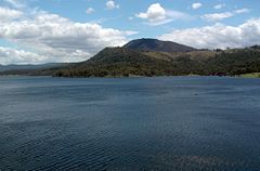
Maroon Dam View west across lake from crest of dam wall, 2010 Location 64 km Southwest of Beaudesert Coordinates 28°10′51″S 152°39′25″E / 28.1807°S 152.657°ECoordinates: 28°10′51″S 152°39′25″E / 28.1807°S 152.657°E Lake type reservoir Primary inflows Burnett Creek Primary outflows Burnett Creek Catchment area 106 km² [1] Basin countries Australia Managing agency SunWater Built 1969 Surface area 350 ha Max. depth 33.6m Water volume 44 300 ML [2] Shore length1 17 km Surface elevation 217.5m References [1][2] 1 Shore length is not a well-defined measure. Maroon Dam is a water storage and recreational dam in South East Queensland. The dam lies 25 km south of Boonah, within the Scenic Rim at the foot of the McPherson Range. Maroon Dam subverts the waters of Burnett Creek, a tributary of Logan River and supplies the Scenic Rim Regional Council with water. Some water is supplied to irrigators along the Logan River.
Construction of the dam occurred between 1969 to 1974. The reservoir was officially opened on 16 July 1975 by Minister for Water Resources Neville Hewitt. The lake contains some areas of standing timber in its upper reaches. It is generally shallow with extensive weedbeds. Drought in February 2003 reduced water levels in the dam to 12%.[3] It was still only at 18% capacity in November 2003.[4]
Contents
Specifications
The dam has a clearance of 10.4 m above full supply level for flood mitigation purposes. This allows for a full operating level at 37,100 ML[5] with a total of 44,300 ML able to be retained.
The spillway is 43.9 m above the original stream bed and the dam wall crest is 46.1 m above the original stream level. The manager of the dam, SunWater is undertaking a dam spillway capacity upgrade program to ensure the safety of the dam is maintained. The spillway is planned to be upgraded in the longer term.[6]
Recreational activities
No camping is permitted on the dam's property.[7] Nearby private accommodation is available.
Fishing and water skiing are popular activities for visitors to the waters held back by the dam. There is a single concrete boat ramp and no restrictions on boat numbers.[7]
Fishing
The dam is stocked with silver perch, golden perch and bass. [7] Additionally spangled perch are present. The Maroon Moogerah Fish Management Association is the local fish stocking group.[7] A Stocked Impoundment Permit is required to fish in the dam.[8]
See also
- List of dams and reservoirs in Australia
- Moogerah Dam
References
- ^ a b Logan River Water Supply Scheme. SunWater. Accessed on 16 September 2007.
- ^ a b Seqwater rainfall and dam level update
- ^ "SES works to fix retaining walls". ABC News Online (Australian Broadcasting Corporation). 24 February 2003. http://www.abc.net.au/news/newsitems/200302/s791168.htm. Retrieved 24 November 2010.
- ^ "Drought drying up Beaudesert water supply". ABC News Online (Australian Broadcasting Corporation). 14 November 2003. http://www.abc.net.au/news/stories/2003/11/14/989100.htm. Retrieved 24 November 2010.
- ^ Rebecca Dull (29 November 2005). "Falls make small impact on dam levels". The Queensland Times (APN News & Media Ltd). http://www.qt.com.au/story/2005/11/29/apn-falls-make-small-impact-on-dam/. Retrieved 24 November 2010.
- ^ Spillway Capacity Upgrade Program
- ^ a b c d Harrison, Rod; Ernie James, Chris Sully, Bill Classon, Joy Eckermann (2008). Queensland Dams. Bayswater, Victoria: Australian Fishing Network. pp. 124–125. ISBN 9781865131344.
- ^ Fishing in Queensland dams? You may need a permit.
External links
Categories:- Lakes of Queensland
- Reservoirs and dams in Australia
Wikimedia Foundation. 2010.


