- North Newbald
-
Coordinates: 53°49′07″N 0°36′56″W / 53.818537°N 0.615655°W
North Newbald 
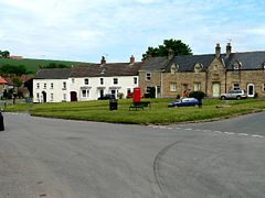
The village green
 North Newbald shown within the East Riding of Yorkshire
OS grid reference SE912366 Parish Newbald Unitary authority East Riding of Yorkshire Ceremonial county East Riding of Yorkshire Region Yorkshire and the Humber Country England Sovereign state United Kingdom Post town YORK Postcode district YO43 Dialling code 01430 Police Humberside Fire Humberside Ambulance Yorkshire EU Parliament Yorkshire and the Humber UK Parliament Beverley and Holderness[1] List of places: UK • England • Yorkshire North Newbald is a village in the East Riding of Yorkshire, England. North Newbald along with the hamlet of South Newbald forms the civil parish of Newbald.
It is a village consisting of roughly 800 people both young and old, and is situated approximately 13 miles (21 km) north west of Hull city centre, 3 miles (4.8 km) north of South Cave and 3.5 miles (5.6 km) south of Market Weighton. It lies to the east of the A1034 road.
The village is has two pubs, named The Tiger and The Gnu (originally the New Inn when owned by The Hull Brewery Company), situated across the road from each other, making a pub crawl a literal option, and several other privately run businesses and a good number of farms. The main industries in Newbald involve farming, eggs and warehouses and transport. It has been a carting village for some centuries.
North Newbald is one of the more picturesque villages in the East Riding of Yorkshire, being home to what Pevsner describes as the most complete Norman church in the East Riding, complete with Coronation Clock (installed at the coronation of George V in 1911), a communal village green, on which is located the whipping post used in the last public flogging carried out in Britain.
The parish church of St. Nicholas, built around 1140, has been described as the 'finest Norman church in East Yorkshire'. It has a large cruciform plan without isles and with a tall central tower. Three Norman doorways make the building almost unique.
North Newbald - a walled town? A previous Vicar of Newbald, Rev. Jack Walker, over his long incumbency, mapped the whole area and produced details drawings suggesting that the village may, very well, have been walled. Apart from Rev. Walker's submissions there is no further evidence of this.
The Yorkshire Wolds Way National Trail, a long distance footpath passes to the east of the village.
The biggest downside for residents is the lack of Public transport - Buses run roughly 3 times a week to Beverley, with few options for return journeys.
Governance
The village was in the Haltemprice and Howden parliamentary constituency until the 2010 general election when it was transferred to the constituency of Beverley and Holderness.[1]
References
- Gazetteer — A–Z of Towns Villages and Hamlets. East Riding of Yorkshire Council. 2006. p. 9.
Categories:- Villages in the East Riding of Yorkshire
- Yorkshire Wolds Way
- East Riding of Yorkshire geography stubs
Wikimedia Foundation. 2010.

