- History of Burnside
-
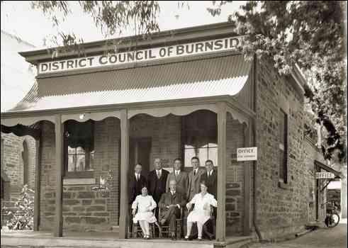
 The Burnside District Council's old Chambers in 1928 (built 1869)
The history of Burnside, a local government area in the metropolitan area of Adelaide, South Australia, spans three centuries. Burnside was inhabited by the Kaurna Indigenous people prior to European settlement, living around the creeks of the River Torrens during the winter and in the Adelaide Hills during the summer. The area was first settled in 1839 by Peter Anderson, a Scots migrant, who named it Burnside after his property's location adjacent to Second Creek (in Scots, 'Burn' means creek or stream). The village of Burnside was established shortly after, and the Burnside Council District was gazetted in 1856, separating itself from the larger East Torrens Council.
The mainstays of the early Burnside economy were viticulture, mining and olive groves; Glen Osmond boasted substantial mineral deposits, and vineyards were established at Magill. The present council chambers were built in 1926 in Tusmore; the council became a municipality in 1935. With strong growth and development throughout the region, Burnside was then proclaimed a city in 1943. The 1960s brought to Burnside a community library and a swimming centre; both were further expanded and upgraded between 1997 and 2001. Today, Burnside is one of Adelaide's most sought-after regions in which to live.[1]
Contents
Early villages
The village of Kensington was established in May 1839, only 29 months after the foundation of the colony. The village was primarily agricultural and had a close relationship with the nearby village of Norwood. The two villages formed one of Adelaide's first municipalities in 1853 as Norwood and Kensington, evolving into today's City of Norwood Payneham St Peters. Parts of Kensington that are now included in Burnside are the suburbs of Kensington Gardens and Kensington Park.[2] The village of Makgill (later Magill) was first established as the 524-acre (2.1 km2) Makgill Estate, owned by two Scots—Robert Cock and William Ferguson—who met onboard the Buffalo en route to the newly founded colony. It was named after Mrs Cock's trustee, David M Makgill.[3] Ferguson, who was charged with farming the estate, built the estate's homestead in 1838.[3] Soon after farming started, the two were short of funds, and thus Magill became the first foothills village to be subdivided.[4][5] The village of Glen Osmond was closely associated with the discovery of silver and lead on the slopes of Mount Osmond by two Cornish immigrants.[6][7] Their discovery of minerals provided the colony with valuable export income, at a time when the early South Australian economy was not yet established and facing bankruptcy.[8] Governor Gawler visited the early discovery and the first mine, Wheal Gawler, was named in his honour. South Australia's first mine exported overseas throughout the 1840s, providing employment to early Cornish and then German immigrants after several mines were bought by a German businessman. The early village assumed a strong Cornish, and later a German character.[6][9] Mining declined after an exodus of workers when a gold rush began in 1851 in the neighbouring colony of Victoria.[10]
The Anderson family was the first to settle the land that was to become the village of Burnside. They brought with them good character testimonials from Scotland, valuable farming experience and 3000 pounds; however, the farming patterns in Scotland differed greatly from those in the antipodes, and the family failed to adapt.[11] The Andersons moved on to Morphett Vale in 1847, selling their land and abandoning their homestead. The buyer of the Anderson land, William Randell, soon decided to build a village in his new property in 1849. He hired surveyor and planner Nathan Hailes to lay out the new village.[11] Hailes was both surprised and disappointed when he found that it had already been settled and left—especially since the growth and adaptation of European foliage to the area.[12] The first villages to be established in the region, those of Glen Osmond, Magill and Kensington had existed for some time when the new village of Burnside was proclaimed.[13] The new village was in a good position to grow; it was bounded by two major thoroughfares, Burnside (now Glynburn) and Greenhill Roads, and had the advantage of lying on Second Creek.[14] The village was soon invested in by many owners; some of whom were wealthy Adelaide folk building an estate in the foothills, and others who were more concerned with working the land.[15] The village was described in advertisements by Hailes in 1850 as "Burnside the Beautiful" with advantages of "perpetual running water, extensive and diversified view, rich garden soil and good building stone ..." with a "... direct, newly-opened and unblemished route to Adelaide".[16]
District councils
Originally, all the villages in what was to become the Burnside District Council were in the then East Torrens District Council of 159 km2 (61 sq mi). East Torrens bordered the River Torrens in the north, the Adelaide Hills to the east, Mount Barker Road to the south, and the Adelaide Parklands to the west. East Torrens was gazetted in 1853 by the District Councils Act 1852; the Act stipulated that there be five elected members to the council, each representing a ward. Dr David Wark (St Bernards), James Cobbledick (Uraidla), Charles Bonney (Norwood), Daniel Ferguson (Glenunga) and George Müller (Stepney) were the council's first representatives. Bonney, in addition to being a councillor, was the Commissioner of Crown Lands. The councillors met for the first time at World's End Hotel in Magill on 12 June 1853. Initial plans were put in place to first survey and evaluate the council area and to collect licence fees and taxes as provided for by the Council's Act. TB Penfold of Magill, a former captain, was to become the first District Clerk and Collector on 1 January 1854. On 4 January 1854 there was a vote in which ratepayers decided on how much they would pay to the council (one shilling to a pound); it was also decided at this point to exempt charitable organisations, schools and churches from rates. In 1855 the population of the council area was 3,705, higher by a thousand than the adjacent Norwood-Kensington.[17] The huge East Torrens was not to prove as stable as Norwood-Kensington. Ratepayers were frustrated as to where their money was going; councillors did not have the administration or funds to operate effectively and the interests of the area were hugely varied. The area was split into three in 14 August 1856. The District Council of Payneham separated and formed to the north-west and the District Council of Burnside was formed in the south-eastern corner in an area of 15.9 km2 (6.1 sq mi).[18] East Torrens was further divided in 1858 with the secession of District Council of Crafers.[19]
Lone Burnside
After shedding the burden of less profitable and unwieldy land with its angry residents, Burnside was on its own. The new Burnside District Council held its first meeting at the Greengate Inn, Tusmore on 19 August 1856. Due to the time it took to elect new councillors, it was not until 29 December that the council met again. Dr Christopher Penfold, chairman, met the rest of the representatives there: Daniel Ferguson of Glenunga, Alexander Ferguson of Monreith, John Townsend of Magill and James Grylls of Belle Vue.[20] It was during this time that Kent Town decided against becoming a part of Burnside and instead applied to enter Norwood-Kensington. The council was to meet at the Inn or at Ferguson's home right up until December 1869, when the first council chambers were built. However, it was still able to operate and fulfill its obligations under the Local Government Act 1852. These included the management of minor roads, the administration of abattoir licences and public houses, and the prevention of the spread of the noxious Scotch thistle. The council was also obliged, under a different act of 1851, to encourage education. Much road and bridgework activity happened after the council had been formed—early residents were amazed at the influx of development and construction that occurred. At the same time, the council was almost overwhelmed by the sheer number of resident requests, and was forced to ask individual ratepayers for monetary assistance when building bridges in their area.[21]
Much of Burnside's history has been observed and documented by institutions that have remained an important part of the lives of its residents: the school and the church.[22] The first school to open in the area was in Magill during 1846, preceding a proper statewide education system. Magill Primary School was enlarged in November 1855, when 38 boys and 29 girls enrolled; they were taught reading, writing, arithmetic, grammar, geography, history, drawing and singing by a sole teacher. By 1865 there were two teachers.[23] Glen Osmond Primary School was established in October 1858, preceding the Glen Osmond Institute, a centre for community debate and learning.[24] Burnside Primary School was built in 1872, taking over from a small private institution.[25] These primary schools, in the absence of proper libraries and similar institutions, received large collections of books and writings from the town's residents. Residents also took advantage of schools for frequent and heated debates on the future of the state and region, and these discussions often drew large crowds. However, even with this intellectual spirit, the adult population was still relatively disadvantaged in the sphere of education. The drive for learning continued until the Boer War placed more emphasis on physical activity and merit within society. Somewhat strangely, this development of learned activity was not replicated in Burnside's traditional centre near Tusmore, where the present Council Chambers, Community Centre and Library are located.[26]
 Glen Osmond Primary School in Fullarton. The school building stands today
By 1871 Burnside had grown significantly; it was now a mix of villages supporting a modest population of 1,557. By comparison, Kensington-Norwood, though smaller in area, had grown to 5,132 persons. Glen Osmond, still affected by its immense growth following the expansion of mining, was the largest single population centre with 343 residents.[27] The District Council had also constructed its first council chambers in December 1869, finally concluding the haphazard meeting agreement. Two villages, Beulah Park (North Kensington) and Eastwood experienced booms in population growth and development between 1870 and 1880, providing both housing to new immigrants and investments for the wealthy Adelaide Establishment.[28] Parkside Hospital (now Glenside), a mental health asylum was constructed in 1866 to replace a crowded building in the Parklands. Built on beautifully tended grounds and with an elaborate façade, it was an early Burnside architectural monument.[29] In 1881 Thomas Cooper started brewing South Australia's first branded beer, 'Coopers', at Leabrook.[30] During this era, Stonyfell saw economic expansion as well; its large quarry changed hands in 1867 and the Stonyfell Olive Co was founded in 1873.[31] The late 19th century was a significant time of development in Burnside. This development, however, was brought to an abrupt end in the last decade, the 1890s, when depression stuck the economies of Australasia after decades of reckless expansion, hitting Burnside hard.[32]
New era
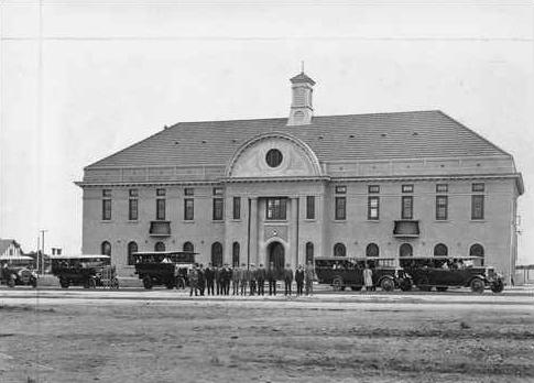
 The Burnside District Council's new Chambers in Tusmore
By the turn of the 20th century, Burnside was becoming more urbanised. Paddocks were still scattered throughout the area but the villages were steadily growing. Toorak Gardens, Dulwich and other near-city villages were gazetted and made open to settlements and advertised now as suburbs, moving on from earlier times.[33] By 1920, the District Council had a population of 17,000, living in 4,000 houses. Ten per cent of the £60,000 budget consisted of commercial enterprise payments, while the rest was made up of ratepayer fees.[34] The South Australian Government had enacted more laws in relation to local government, in particular, the Town Planning Act 1920 and the Building Act 1923.[35] These assigned more responsibility to councils, but at a time of necessity; Adelaide was gradually expanding.[35] Burnside councillors advised the State Government to acquire and manage pleasure resorts; a kiosk was opened at Waterfall Gully and the Morialta Conservation Park established on this advice.[36] Burnside was treated with high regard by Adelaide newspapers in response to its elaborate greening and tree planting schemes.[37] "Beautiful Burnside: Picturesque Streets" was the headline of The Chronicle on 24 March 1928. The council was preserving old trees and planting approximately 500 a year.[37] A Burnside councillor, HES Melbourne, was adored in this period; he spent his own money acquiring reserves and land for residents due to a lack of funds during the Great Depression. He presided over lean but reasonable budgets and oversaw the planting of trees and foliage to beautify the city. Gordon Allen, a local resident who succeeded Melbourne as a councillor, described Melbourne: "No Council ever had a better man."[38] Melbourne also oversaw the building of the Mount Osmond golf course, but his vision of constructing a Country Club was never realised.[39]
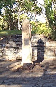 A Memorial Obelisk to Burnside's fallen in World War I, located in Hazelwood Park
Development restrictions preceding the Hills Face Zone were established in the 1920s; the Council was obligated to adhere to strict guidelines.[40] 1928 saw the building of grand new Council Chambers at the corner of Greenhill and Portrush Roads; they are still in use today.[41] Floods devastated Waterfall Gully in 1931.[42] Burnside continued to grow; in 1935 the District Council of Burnside became the Municipality of Burnside.[43] By 1941, only 401 acres (1.6 km2) remained under cultivation. Bushfires in the 1940s caused considerable damage to the hills, particularly as the war effort had diverted supplies and personnel from the Country Fire Service.[citation needed] In 1945, much of the area that forms today's Cleland Conservation Park was purchased by the State Government, in large part because of the lobbying efforts of Professor Sir John Cleland. Most of this land, including the Waterfall Gully area, was later combined in 1963 to create the park that extends eastwards up into the hills to the summit of Mount Lofty and northwards to Greenhill Road.[44] During 1943, the Municipality of Burnside was proclaimed the City of Burnside.[1][43]
Many of Burnside's sons fought in World Wars I and II; on their return they were honoured with memorials, and in particular, the name of Burnside's first community hospital. The Burnside War Memorial Hospital was opened on April 1949 in Toorak Gardens, built in a house donated by a local resident, Otto van Reiben. The present name was adopted in 1956.[45][46] Memorials to the fallen can be found all over Burnside; in Hazelwood Park opposite the swimming centre, at schools and churches, in reserves. Like much of Australia, Burnside held true to the phrase "Lest We Forget", which is emblazoned on many of the community-erected memorials. In Rose Park on Alexandra Avenue, there is a large monument and statue of an Australian Imperial Force soldier with its plaque stating: "In Memory of the Fallen: World War II, Korea, Vietnam".[47][48] Upon their arrival home the servicemen formed several Returned Services League clubs in the City of Burnside.
Centennial
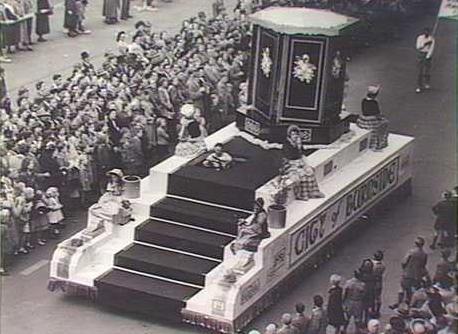
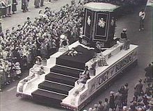 Burnside celebrates Australia's jubilee in 1951.
When Australia celebrated the Golden Jubilee of the Federation of Australia in 1951, Burnside residents joined in the celebrations, and in 1956 commemorated the centennial of their own town.[43] A post-war economic and baby boom under the Playford Government[49] saw Burnside grow at a spectacular rate; from a population of 27,942 in 1947, it grew to 38,768 in 1961.[50] As suburbs devoured the remaining paddocks, 1953 saw the building of a public ballroom, 1965 saw an Olympic Grandstand; both in Kensington Park.[51] In 1963 the Cleland Conservation Park was founded on Burnside's eastern borders.[44]
Burnside's road system was completely bitumenised during the 1960s and 1970s through government-sponsored roadworks programmes. Plans were also laid out to replace the windy and dangerous Mount Barker Road. One of these proposals was the Burnside-Crafers Highway, which was strongly supported by council; it envisaged leaving Greenhill Road once reaching Hazelwood Park. It was then to pass through Hazelwood Park and Beaumont, wind around the hills of Waterfall Gully and then go over Eagle on the Hill to meet Crafers. The Burnside Council put much effort into this proposal, widening Linden Avenue (which runs north-west to south-east) in preparation for the highway. The proposal was eventually rejected in favour of upgrading Mount Barker Road and Linden Avenue remained a huge out-of-place road running through an otherwise peaceful suburb.[52]
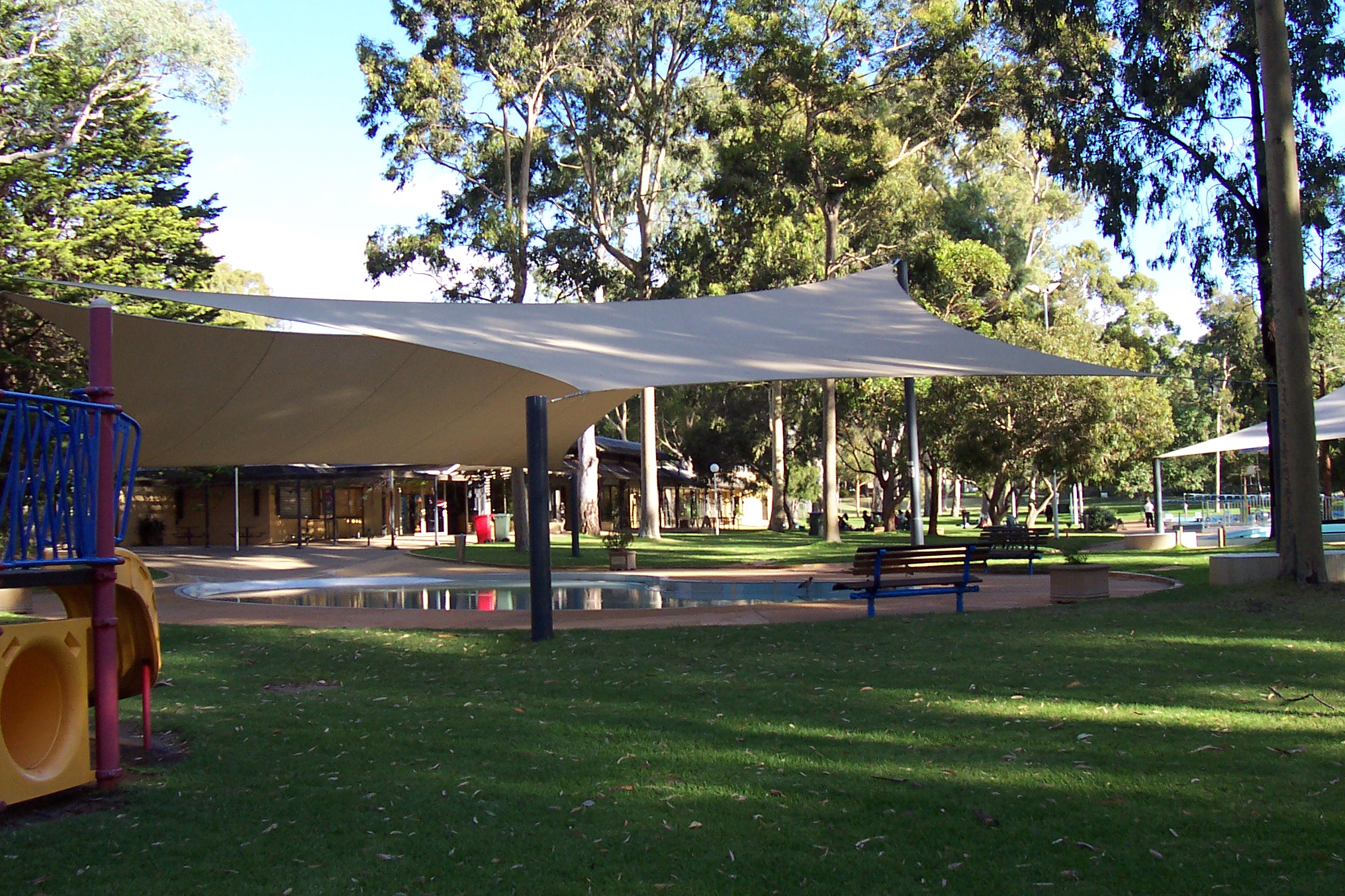
 The swimming centre in Hazelwood Park today
Burnside gained a public library with a collection of 7,800 books in 1961 after it was first suggested in February 1959; the cost of establishing a library for the residents was more affordable since the Libraries Act 1955 had been passed.[53] The Burnside Swimming Centre opened in 1966; the swimming centre was a pet project of then-Mayor George Bolton, who had a grand vision of what he wanted Hazelwood Park, where the centre was to be located, to become. Bolton met unprecedented public opposition in 1964 when the idea was first unveiled.[54] The substantial elderly population of Burnside (15%) was wholly opposed to the idea, suggesting the influx of troublemakers and noise was hardly worth the effort. The cost was estimated at £75,000 (£1,130,000 as of 2011). While architects were resigning over the scale of the proposed development and a number of residents were up in arms, the Adelaide newspapers had a ball; cartoonists throughout 1964 spent many of their daily cartoons covering the debacle.[55] With the failure of a poll to decide the fate of the idea on 24 March the Sunday Mail published the headline "Burnside Says NO to Swim Pool".[51] Mayor Bolton was not dismayed by the result; he pushed ahead with his idea and announced new plans in December. After a strong public campaign and minor changes to the project a poll in February 1965 voted strongly in favour of the idea. The Mayor had won his battle and it was christened the George Bolton Swimming Centre in his honour upon opening.[56]
The Burnside Council decided on an ambitious goal in 1967: for every 1,000 in population, five hectares of reserves were to be set aside.[44] Setting out to achieve this the council purchased Hazelwood Park from the State Government, the Beaumont Common from its residents and parts of Mount Osmond were attained from the Highways Department.[57] Before coming into the ownership of the council, Hazelwood Park was destined to be subdivided under a government initiative. When council heard of this, motions were put into place to take ownership and the deed was transferred in 1964. The council only managed this after discussions were held with Premier Playford himself.[58]
Modernity
A community centre was built alongside the council chambers in 1982, adjoining the library. The entire council complex was upgraded first in 1996, together with an upgrade of the Burnside Swimming Centre. Further upgrades took place in 2001, resulting in a modern library and community centre for residents. Burnside developed a new council logo in 1993, utilising the colours of green and purple. Green represents the lush parks and reserves in Burnside, and purple represents the prominent Jacaranda trees. The adjacent suburbs of Skye and Auldana were merged into Burnside in 1999. Formerly part of the Adelaide Hills Council they had a lengthy association with Burnside dating back to the days of East Torrens. Coopers Brewery moved out of Leabrook in 2001, relocating to Regency Park, their former premises converted into a retirement village.[1]
Burnside will have to adapt to deal with an ageing population; the largest age group in the area is that of the 35–49 group, who will soon retire. Already 23.7% of the population is over 60 and more people die every year than are born. Almost all population growth is from inter-Adelaide as well as overseas migration. A portion of the population emigrates to other Australian states and cities. Consistent since the 1960s, there is a huge gap in the 18–25 year old group which is unlikely to change.[59][60]
References
- Bromell, W. & Hannan, F.P: Mines in Burnside - Their Historical Significance, published 1981
- Coleman, D (editor): The First Hundred Years - A History of Burnside in SA, published 1956
- Cox, A. Bertram: Fairways on the Mount - A History of the Mount Osmond Golf Club, published 1977
- Warburton, E: The Paddocks Beneath - A History of Burnside from the Beginning, published 1981
Notes
- ^ a b c City of Burnside: History (http://www.burnside.sa.gov.au/site/page.cfm?u=668) Accessed 27 April 2006 Archived April 4, 2006 at the Wayback Machine
- ^ Warburton, pp. 236, 245, 331, 336.
- ^ a b Warburton, p. 197.
- ^ Ifould in Coleman, p. 42.
- ^ Warburton, pp. 197–199.
- ^ a b Warburton, pp. 110–114.
- ^ Warburton, pp. 106–108.
- ^ Warburton, p. 111.
- ^ Postcards: Glen Osmond Mines (http://esvc001353.wic010u.server-web.com/features/glen_osmond_mines.html) Accessed 27 April 2006
- ^ Ifould, pp. 32–33.
- ^ a b Warburton, p. 2.
- ^ Warburton, p. 3.
- ^ Warburton, pp. 1–3, 106–108, 197–199.
- ^ Warburton, pp. 1, 3.
- ^ Warburton, pp. 4–30.
- ^ Warburton, pp. 3–4.
- ^ City of Norwood Payneham St Peters: Norwood-Kensington History (http://www.npsp.sa.gov.au/ssi-council/html/council/kensington/) Accessed 27 April 2006 Archived June 17, 2005 at the Wayback Machine
- ^ Melbourne in Coleman, p. 11.
- ^ Warburton, pp. xxiii–xxiv.
- ^ Warburton, p. xxvi.
- ^ Warburton, p. xxix.
- ^ Hill in Coleman, pp. 123–126.
- ^ Magill School: History (http://www.magillps.sa.edu.au/) Accessed 27 April 2006
- ^ Warburton, pp. 308–309.
- ^ Adey in Coleman, pp. 135–136.
- ^ Warburton, p. 310.
- ^ Warburton, p. 355.
- ^ Warburton, pp. 265–266.
- ^ Warburton, pp. 272–273.
- ^ Coopers Brewery: Students Guide (http://www.coopers.com.au/pdfs/studentInfo.pdf) Accessed 27 April 2006
- ^ Warburton, pp. 41–42.
- ^ Warburton, p. xx.
- ^ Warburton, pp. 294–295.
- ^ Warburton, p. 321.
- ^ a b Warburton, p. 324.
- ^ Warburton, p. 322.
- ^ a b Warburton, p. 332.
- ^ Warburton, pp. 322–323.
- ^ Warburton, p. 195.
- ^ Warburton, p. 328.
- ^ Warburton, p. 89.
- ^ Warburton, p. 331.
- ^ a b c Warburton, p. 351.
- ^ a b c Warburton, p. 333.
- ^ Melbourne in Coleman, pp. 107–109.
- ^ Warburton, p. 298.
- ^ Cockburn in Coleman, pp. 97–99.
- ^ War Memorials in Australia: Burnside District Soldiers Memorial (http://www.skp.com.au/memorials/pages/50052.htm) Accessed 27 April 2006
- ^ Hugo, Graeme (1996). "Playford's people: Population change in South Australia". In O'Neil, Bernard; Raftery, Judith; Round, Kerrie (eds). Playford's South Australia: Essays on the History of South Australia, 1933–1968. Association of Professional Historians. pp. 30–50. ISBN 0-646-29092-4.
- ^ Warburton, p. 357.
- ^ a b Warburton, p. 336.
- ^ Ozroads: Princes Highway (http://www.ozroads.com.au/SA/New/1/PrincesM/history.htm) Accessed 27 April 2006
- ^ Warburton, p. 346.
- ^ Warburton, pp. 334–335.
- ^ Warburton, p. 335.
- ^ Warburton, pp. 334–337.
- ^ Warburton, pp. 337–339.
- ^ Warburton, p. 334.
- ^ City of Burnside: Community Profile (http://www.id.com.au/burnside/commprofile/default.asp?id=139&gid=10&pg=0&svg=0&bhcp=1) Accessed 27 April 2006
- ^ City of Burnside: Population Forecasts (http://www.id.com.au/burnside/forecastid/) Accessed 27 April 2006)
City of Burnside History of Burnside · Burnside Civic Centre · Burnside War Memorial Hospital · Burnside Village
Auldana · Beaumont · Beulah Park · Burnside · Dulwich · Eastwood · Erindale · Frewville · Glen Osmond · Glenside · Glenunga · Hazelwood Park · Kensington Gardens · Kensington Park · Leabrook · Leawood Gardens · Linden Park · Magill · Mount Osmond · Rose Park · Rosslyn Park · St Georges · Skye · Stonyfell · Toorak Gardens · Tusmore · Waterfall Gully · Wattle ParkCategories:


Wikimedia Foundation. 2010.