- Dong Hoi
-
Dong Hoi
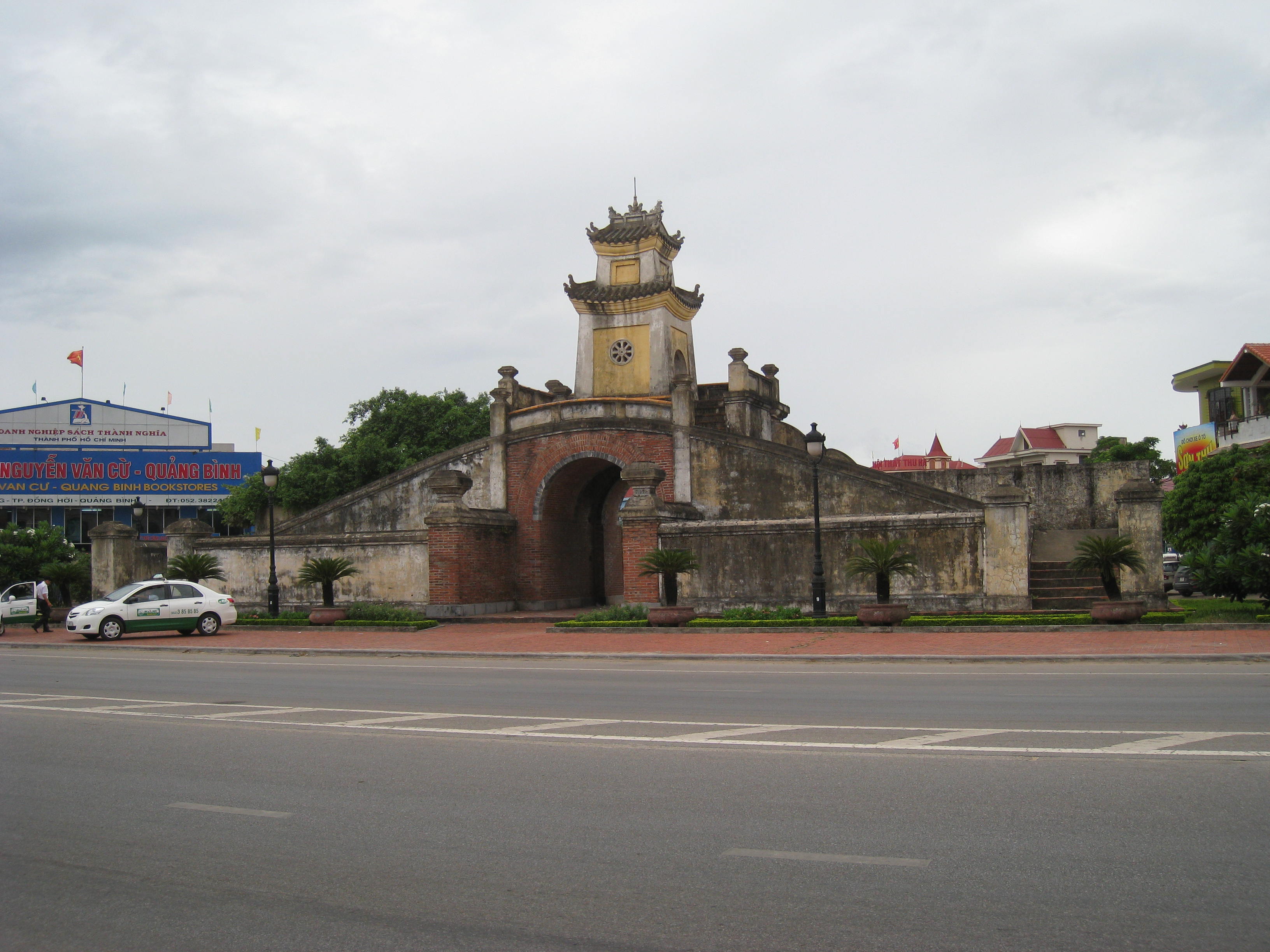
Thành phố Đồng HớiQuang Binh Old Citadel Gate in Dong Hoi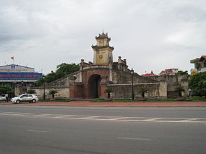
Nickname(s): City of roses Location in Vietnam
 Dong Hoi
Coordinates: 17°28′59″N 106°35′59″E / 17.48306°N 106.59972°ECoordinates: 17°28′59″N 106°35′59″E / 17.48306°N 106.59972°E Country  Vietnam
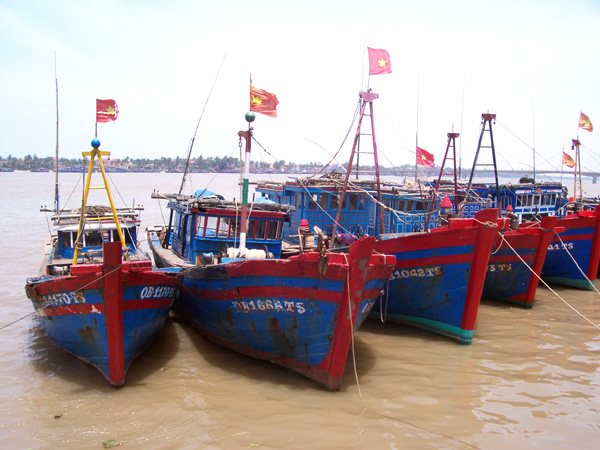
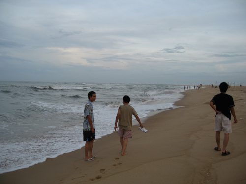
Province Quang Binh Ward (phuong) and commune (xa) Government - Type City municipality - General of the Municipal Communist Party Committee - Chairman of the Municipal People's Committee Area - Total 155.71 km2 (60.1 sq mi) Population (2009) - Total 108,526 - Density 697/km2 (1,805.2/sq mi) Registered residents only Time zone Vietnam (UTC+7) Airport Dong Hoi Airport (domestic) Website [2] 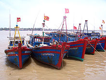 Fishing boats in Đồng Hới.
Đồng Hới (
 listen) is the capital city of Quang Binh province, in the north central coast of Vietnam. The city’s area is 155.71 km2 (60.12 sq mi), population as per the 2009 census: 108,526. Urban area is 55.47 km², urban population was 71,620; Suburban area is 100.24 square kilometers, suburban population was 36,906.[1] The city is served by the Dong Hoi Railway Station, National Highway 1A and Dong Hoi Airport.
By the road, Đồng Hới is 486 kilometres (302 mi) south of Hanoi, 195 kilometres (121 mi) south of Vinh, 172 kilometres (107 mi) north of Huế and 1,238 kilometres (769 mi) north of Ho Chi Minh City.[2] It borders Quảng Ninh District on the west and south, the South China Sea on the east, Bố Trạch District on the north.[3][4]
Dong Hoi has 12-km-long coastline with white sand beaches.[5] Đồng Hới is the closest city to Phong Nha-Ke Bang National Park, UNESCO’s World Natural Heritage Site located 50 km north of the city.
Contents
History
Archaeological excavation in this area proved that human living in what is now Quảng Bình province in the Stone Age period. Many artifacts, such as ceramic vases, stone tools, and china, have been unearthed in Quang Binh.[4][6]
In 1926, a French female archaeologist, Madeleine Colani discovered and excavated many artifacts in caves and grottoes in west mountainous areas of Quang Binh. She concluded that there existed the Hòa Bình culture in this region. Through C14 dating test, the artifacts here dated back to 10,509 (plus or minus 950) ago.[4]
From Quy Dat township (Tuyên Hóa) to southwest about 150 m, the Hum grotto contains many stone tools and animal stones from an ancient human community. Inside Khai grotto near Quy Dat township, similar artifacts were also found. Especially, there are several ceramic of Dong Son culture.
Additionally, artifacts of the Stone Age period were also unearthed in some grottoes in Quang Binh region. Owners of these artifacts lived in the caves and grottoes and hunted for their food.[4]
Human settlement in Đồng Hới can be traced to 5,000 years ago. Many relics and remnants have been found by the Vietnamese and French archaeologists in Bau Tro, a lake in the city. Most of the finds here belong to the Stone Age period. Around 2880 BC, the site of modern Đồng Hới was a territory of Viet Thuong tribe of Văn Lang (Vietnam) during the reign of king Hùng Vương. The site was long a disputed territory between the Champa kingdom and Đại Việt. It officially became Đại Việt territory in 1069 after Ly Thuong Kiet took victory over Champa in this area as a result of Dai Viet-Champa War. The area ceased to be the southernmost of Dai Viet after the political marriage of the Trần Dynasty princess, Huyền Trân, to Champa king, Jaya Sinhavarman III (Vietnamese: Chế Mân). Princess Huyền Trân was king Trần Nhân Tông's daughter and king Trần Anh Tông's younger sister. Political matches made to acquire land was a traditional practice by Champa kings. Thanks to this marriage, Đại Việt acquired lands (as dowry) of what is now Quảng Trị Province, and Thua Thien-Hue Province (provinces which were then known respectively as Chau O and Chau Ri or Chau Ly).[7][8]
During the time of the Trịnh-Nguyễn War (1558–1775), Vietnam was divided into two countries: Dang Trong (South) and Dang Ngoai (North) with the Gianh River as frontier line. Đồng Hới was an important fortress of the southern Nguyễn Lords. The Đồng Hới Wall (Vietnamese: Thành Đồng Hới) was considered the barrier which protected the Nguyễn Lords from the attack by northern Trịnh family. During the Indochina War (between the French and the Viet Minh in 1950s), the Đồng Hới airbase was used by the French to attack both the Viet Minh in north-central Vietnam and the Laotian Pathet Lao Army in central and southern Laos. During the Vietnam War, Đồng Hới was heavily devastated by bombardments from the United States B-52 due to its location near seventeenth parallel and the Demilitarized Zone between North Vietnam and South Vietnam.[9][10] On April 19, 1972, during a major North Vietnam offensive, a task force of four US ships was sailing off the coast of Vietnam. They were the USS Oklahoma City, USS Sterett, the USS Lloyd Thomas and the USS Higbee. They were attacked by three North Vietnamese MiGs in an attack known as battle of Đồng Hới. In an attempt to surprise the task force, the MiGs came in low, described as getting their feet wet. Despite the official stories, they did not surprise the task force, which had spotted them long before engagement range and were ready to shoot. Two ships, the Oklahoma City, and the Sterett, had anti-aircraft missiles, while the Higbee and the Lloyd Thomas were armed with dual purpose 5" guns. All ships were at battle stations. This city is also the narrowest land of Vietnam (around 40 km from the east to the west) After the fall of Saigon on April 30, 1975, Quảng Bình province was merged into Bình Trị Thiên province (Bình Trị Thiên is the abbreviation of Quảng Bình, Quảng Trị, and Thừa Thiên provinces). In 1990, Bình Trị Thiên was once again separated into three provinces as it had been before. Đồng Hới then became the capital of Quảng Bình province.
Geography
Location
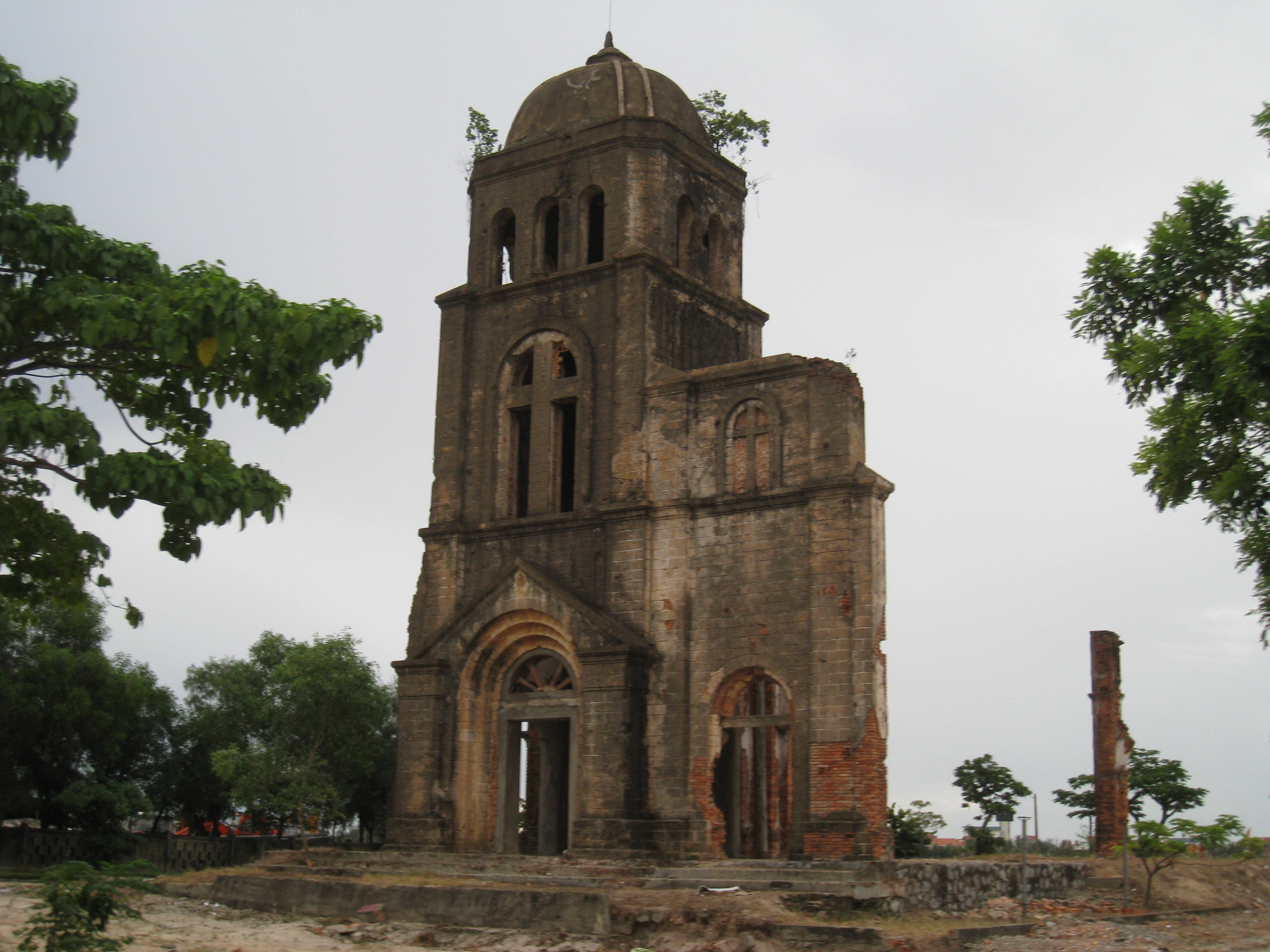
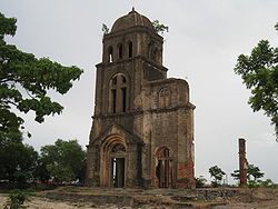 Remnant of Tam Tòa Church in Đồng Hới
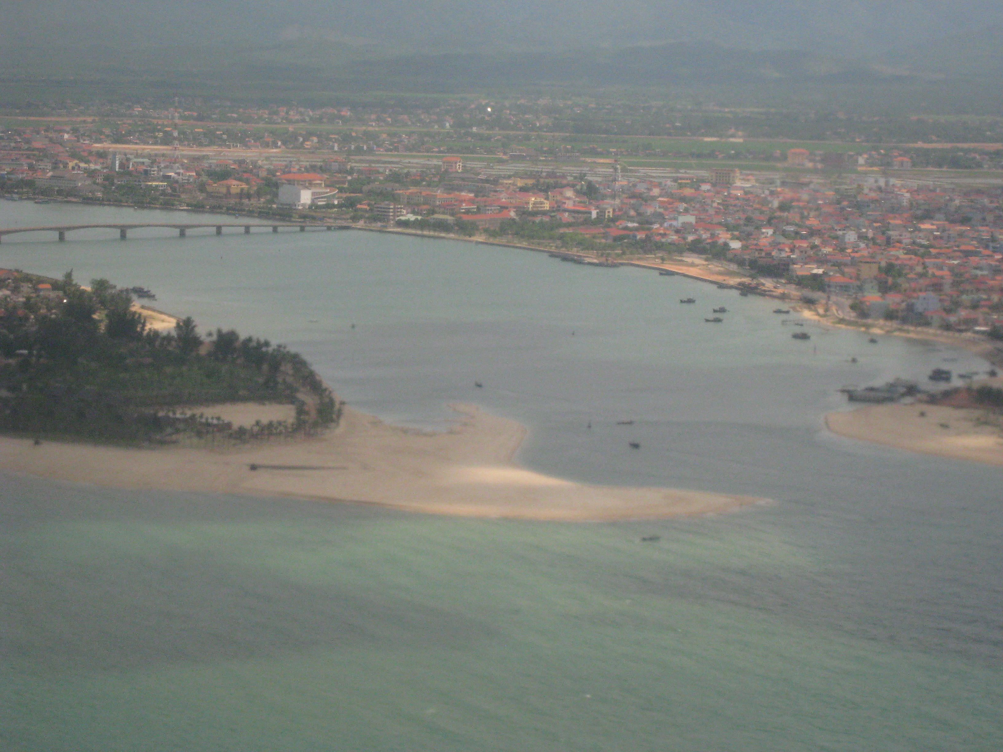
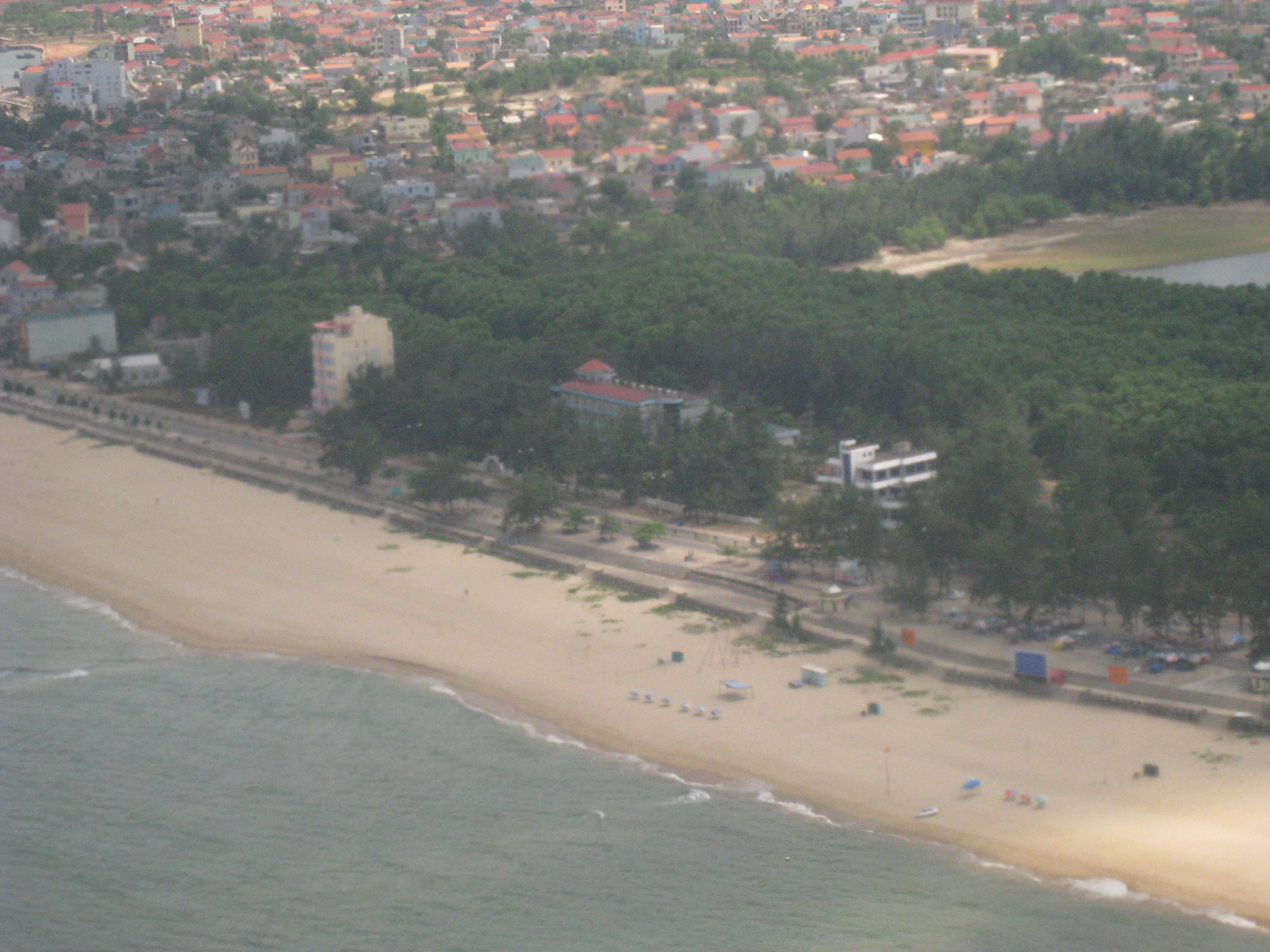
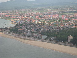 Đồng Hới seen from the air
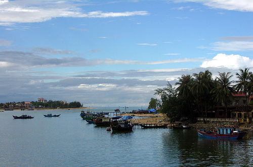
Đồng Hới is located on the National Road 1A, North-South Railway and Ho Chi Minh Highway, at the coordinates 17 21' N and 106 10’ E. This city is situated in the heart of Quang Binh Province. It borders Bố Trạch on the north, Quang Ninh on the south, South China Sea on the east, Quang Ninh on the west. It is 50 km south of Phong Nha-Ke Bang National Park, 50 km north of Bang Spa, 180 km southeast of Cha Lo border gate with Laos. It has a coastline of 12 km. Nhật Lệ River is the only river that runs through the city. Tro Lake is the source of fresh water for the city-dwellers. The Nhat Le Beach is endowed with fine and white sand.[3]
Climate
Like all provinces in north and north central of Vietnam, there are four distinct seasons in Đồng Hới. In the spring, it is cool, humid and foggy. The average annual temperature is 24.40C, average rainfall varies from 1,300 – 4,000 mm, total sunshine hours per year is 1,786 hours, average annual moisture is around 84%. The city has moonson climate with three types of wind: southeast wind (gió nồm), southwest wind (gió nam), and northeast wind.
Although the city is located by the sea, its climate is subject to drought in the summer, this is largely due to the dry southwest wind from Gulf of Thailand (this flow of wind is wet but when it passes to Vietnam, Annamite Range mountain range keeps its humidity to cause rains in Laos but drought in central Vietnam). It is rainy in the fall but the weather is comfortable with the temperature around 26 to 31 degrees Celsius. In the winter, due to the northeast wind blowing from the Chinese mainland, the temperature may go down below 18 degrees Celsius, and there may be slight rain. The highest precipitation gets highest level in August (118.4 mm), compared to just 38.9 mm in January.[11]
Average temperature Jan Feb Mar Apr May Jun Jul Aug Sep Oct Nov Dec Highest (°C) 22 23 25 29 32 34 34 33 31 28 26 23 Lowest (°C) 17 18 20 23 25 27 27 26 25 23 21 18 Sources: msn weather Topography and geology
The city has diverse topographical and geological features, including hill, mountainous, half mountainous, coastal plains and coastal sand dunes.
Hilly region is located in the west part of the city, stretching from north to south (in parts of communes: Dong Son, Thuan Duc) with an average elevation of 12–15 m, with total area of 64.93 km², 41.7% of the city total area. Residents here live on agriculture, forestry, farming. The soil in this are is poor in nutrition, unfertile and subject to continuous erosions due to its slope of 7 - 10%.
Half hilly region surrounds a plain with an average elevation of 10 m from northeast - north to northwest – southwest and south – southeast. This region covers commues and wards of Bắc Lý, Nam Lý, Nghĩa Ninh, Bắc Nghĩa, Đức Ninh, Đức Ninh Đông, Lộc Ninh and Phú Hải with total area of 62.87 km², or accounts for 40.2% of the city total area. Residents here lives on industrial, handcraft, trading and a small percentage lives on farming. This region is not very fertile, subject to alum. However, thanks to the heavy distribution of rivers and lakes, ponds and pools, it's better for agriculture than those in hilly region. The plain with the average of 2.1 m, with little slope, accounting for 0.2% of the city total area (5.76 km²). Most of the city's commercial, administrative and main streets concentrate in this narrow regions.
Coastal sand dune area is located on the east of the city, with an area of 21.98 km², making up 14,3% of the total area. This region features several sand dunes. Many small fresh water ponds are sandwiched into sand dunes, namely Bàu Tró, bàu Nghị, Bàu Tràm, Bàu Thôn, and Bàu Trung Bính.
Administration
Đồng Hới is subdivided into 16 subdivisions, 10 urban wards (phường) and 6 rural communes (xã).[1]
No. Name Vietnamese Population 2009 Area (km²) Inner Wards: 1. Bac Ly Phường Bắc Lý 14,158 10.19 2. Bac Nghia Phường Bắc Nghĩa 6,981 7.76 3. Dong My Phường Đồng Mỹ 2,757 0.58 4. Dong Phu Phường Đồng Phú 8,646 3.81 5. Dong Son Phường Đồng Sơn 9,127 19.65 6. Duc Ninh Dong Phường Đức Ninh Đông 5,031 3.13 7. Hai Dinh Phường Hải Đình 3,878 8.822 8. Hai Thanh Phường Hải Thành 4,774 2.45 9. Nam Ly Phường Nam Lý 11,912 3.9 10. Phu Hai Phường Phú Hải 3,581 3.06 Total Inner Wards 10 wards 10 phường 71,620 55.47 Suburban Communes: 11. Bao Ninh Xã Bảo Ninh 8,906 16.3 12. Duc Ninh Xã Đức Ninh 7,526 5.21 13. Loc Ninh Xã Lộc Ninh 8,647 13.4 14. Nghia Ninh Xã Nghĩa Ninh 4,642 16.22 15. Quang Phu Xã Quang Phú 3,178 3.23 16. Thuan Duc Xã Thuận Đức 3,788 45.28 Total Suburban Communes 6 communes 6 xã 36,906 100.24 Whole City 10 wards, 6 communes 10 phường, 6 xã 108,526 155.71 Tourism
 Dong Hoi
Đồng Hới is endowed with beautiful beaches with fine sand and clean water of Nhat Le. The Da Nhay and Ly Hoa beaches (60 km north of the city) are popular tourist destinations. The Bang Spa (hot mineral spring) is ideal for those who enjoy spa baths. The city is situated 50 km south of the World Heritage Phong Nha-Ke Bang National Park which is ideal for cave and grotto exploration and biological research activities (mainly Phong Nha Cave, Tien Son Cave and from September 2010 Thien Duong Cave, Son Doong Cave has yet been available for visitors). Đồng Hới is also included in former battlefield tours where travelers can visit several once dangerous fields along Annamite Range and Ho Chi Minh Trail.[12] Đồng Hới is accessible by road (National Highway 1A, Hồ Chí Minh Highway), by rail at Dong Hoi Railway Station on the Hà Nội-Hồ Chí Minh City Railway, or by air from Hà Nội or Hồ Chí Minh City at Dong Hoi Airport, an airport that the construction was completed and put into use on May 18, 2008.[13] The consrtuction schedule of the airport was late due to lack of capital from the government. It was scheduled to be completed in February 2008, but there are some pending items (10% of the total work), the deadline was extended.[14] The airport was completed and opened on May 18, 2008 with the first commercial flight from Hanoi's Noi Bai International Airport and followed by air link with Ho Chi Minh City's Tan Son Nhat International Airport from July 1, 2009.[15][16] The city provides tourists with 98 hotels and guest-houses from 1 to 3-star hotels like Cosevco Hotel, Saigon-Quảng Bình Hotel and especially the 4-star resort of Sun Spa Resort. The available cuisine includes seafood, the traditional "hot pot", Vietnamese and European-style meals. In 2005, the city welcomed nearly 300,000 visitors.
Economy
The Hòn La bay is a 4-square-km bay, with the depth up to 15 m, suitable to develop into a deep-water sea port, a port is currently (as of 2006[update]) under construction north of Đồng Hới, the port when finished will be able to accommodate ships up to 50,000 metric tons, located on a 32ha of land, has a loading capacity of 10-12 million tonnes per year and is expected to facilitate business for Quang Binh's industrial and economic zones once operational.[17][18] Two industrial parks (Northwest Đồng Hới Industrial Park and Hòn La Industrial Park) are also under construction and partially available now to investors. The city achieved an average economic growth rate of 12.5% during 2001-2005 period. The economic contributors for 2005 were as follows: industry and construction accounting for 35.5%, services 50.9%, agriculture-forestry-fishery 13.6%. GDP per capita in 2005 was $750.
Education
Đồng Hới is home to Quang Binh University, a multidisciplinary uiversity. There are several schools here, notable Đào Duy Từ School.
See also
References
- ^ a b Official website
- ^ Du lịch đường bộ
- ^ a b Quang Binh
- ^ a b c d Quang Binh, Nuoc non huyen dieu, Van Nghe Publishing House, 2000, p.14, 15, 16, 17
- ^ [1]
- ^ Da But Culture "Evidence for Culture Development in Vietnam during the Middle Holocene". http://ejournal.anu.edu.au/index.php/bippa/article/viewFile/87/78 Da But Culture. Retrieved 2008-03-05.
- ^ Tran Dynasty
- ^ "Kingdom of Champa". ancientworld. http://www.ancientworlds.net/aw/Article/549713. Retrieved 2008-03-06.
- ^ U. S. Hits Dong Hoi Again, Russ Say
- ^ B-52's Raid Supply Routes South of the 20th Parallel; U. S. Planes, by Mistake, Bomb Base at Da Nang and Wound 10 Emergency Program Ordered Loss of A-7 Reported 2 Cambodian Villages Periled
- ^ msn weather
- ^ Ho Chi Minh Trail & Vietnam War Retrospective By Award Winning Veteran Combat Photographer
- ^ "Construction begins on new Quang Binh airport". Vietnam News. 2004-09-01. http://vietnamnews.vnanet.vn/2004-08/31/Stories/16.htm. Retrieved 2008-02-27.
- ^ T, T (October 21, 2007). "Sân bay Đồng Hới sẽ được đưa vào khai thác trong dịp Tết Nguyên đán 2008". Ministry of Transport (Vietnam). http://www.giaothongvantai.com.vn/Desktop.aspx/News/tin-tuc-su-kien/San_bay_Dong_Hoi_se_duoc_dua_vao_khai_thac_trong_dip_Tet_Nguyen_dan_2008/. Retrieved 2008-02-27.
- ^ "Flag carrier to launch HCMC – Đồng Hới route in early July". Communist Party of Vietnam. 2009-06-15. http://www.cpv.org.vn/cpv/Modules/News_English/News_Detail_E.aspx?CN_ID=345451&CO_ID=30318.
- ^ Chau, Thanh (January 16, 2008). "Cần đẩy nhanh tiến độ xây dựng sân bay Ðồng Hới". Ministry of Construction (Vietnam). http://www.baoxaydung.com.vn/Main.aspx?MNU=1115&Style=1&ChiTiet=4646. Retrieved 2008-02-27.
- ^ "Hon La Port to be linked with mainland (Shipping News in brief)". Ecnext. 2003-06-09. http://goliath.ecnext.com/coms2/gi_0199-3069037/Hon-La-Port-to-be.html. Retrieved 2008-03-06.
- ^ "President Triet tours provinces". Vietnamnews. 2008-01-28. http://vietnamnews.vnagency.com.vn/showarticle.php?num=05SOC280108. Retrieved 2008-03-06.
External links
 Districts of North Central Coast (Bac Trung Bo)
Thanh Hoa province 
Nghe An province Ha Tinh Province Quang Binh province Quang Tri province Thua Thien-Hue province Quảng Bình ProvinceCapital: Đồng Hới Đồng Hới Bắc Nghĩa • Đồng Mỹ • Đồng Phú • Đồng Sơn • Đức Ninh Đông • Hải Đình • Hải Thành • Nam Lý • Phú Hải • Bảo Ninh • Đức Ninh • Lộc Ninh • Nghĩa Ninh • Quang Phú • Thuận Đức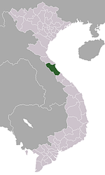
Bố Trạch District Hoàn Lão • Bắc Trạch • Cự Nẫm • Đại Trạch • Đồng Trạch • Đức Trạch • Hạ Trạch • Hải Trạch • Hòa Trạch • Hoàn Trạch • Hưng Trạch • Lâm Trạch • Liên Trạch • Lý Trạch • Mỹ Trạch • Nam Trạch • Nhân Trạch • Phú Định • Phú Trạch • Phúc Trạch • Sơn Lộc • Sơn Trạch • Tân Trạch • Tây Trạch • Thanh Trạch • Thượng Trạch • Trung Trạch • Vạn Trạch • Xuân TrạchLệ Thủy District Kiến Giang • Nông Trường Lệ Ninh • An Thủy • Cam Thủy • Dương Thủy • Hải Thủy • Hoa Thủy • Hồng Thủy • Hưng Thủy • Kim Thủy • Lộc Thủy • Liên Thủy • Mai Thủy • Mỹ Thủy • Ngân Thủy • Ngư Thủy • Ngư Hòa • Phong Thủy • Phú Thủy • Sen Thủy • Sơn Thủy • Tân Thủy • Thái Thủy • Thanh Thủy • Trường Thủy • Văn ThủyMinh Hóa District Quảng Ninh District Quảng Trạch District Ba Đồn • Quảng Đông • Cảnh Dương • Quảng Phú • Quảng Xuân • Quảng Phúc • Quảng Thọ • Quảng Liên • Quảng Tiến • Quảng Lưu • Quảng Kim • Quảng HợpTuyên Hóa District Categories:- Dong Hoi
- Populated places in Quang Binh Province
- District capitals in Vietnam
- Districts of Quang Binh Province


Wikimedia Foundation. 2010.