- New York State Route 93
-
NYS Route 93
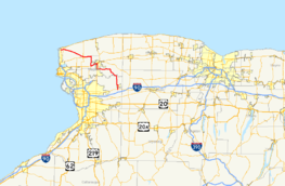
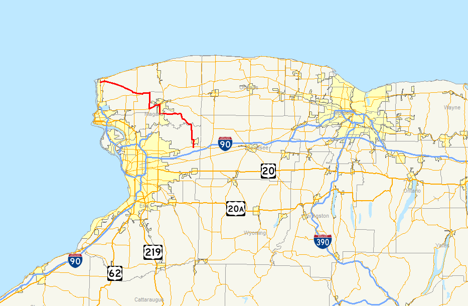
Map of western New York with NY 93 highlighted in redRoute information Maintained by NYSDOT Length: 43.08 mi[2] (69.33 km) Existed: 1930[1] – present Major junctions West end:  NY 18F in Youngstown
 Robert Moses Parkway in Youngstown
 NY 78 in Lockport
East end:  NY 5 near Akron
Location Counties: Niagara, Erie Highway system Numbered highways in New York
Interstate • U.S. • N.Y. (former) • Reference • County←  NY 92
NY 92NY 94  →
→New York State Route 93 (NY 93) is a state highway in western New York in the United States. It runs in a northwest–southeast direction between NY 18F near the Niagara River in the village of Youngstown and NY 5 just south of the village of Akron. NY 93 passes through the area around the city of Lockport; however, it bypasses much of the city to the west and south. As the route progresses southeastward from Youngstown, it intersects several regionally important highways, including NY 104 and NY 78.
Contents
Route description
NY 93 begins in the center of the village of Youngstown, heading east from an intersection with NY 18F (Main Street) along Lockport Street. It meets the Robert Moses State Parkway at an interchange at the eastern village line then proceeds in an east southeast direction across the town of Porter as Youngstown-Lockport Road, passing through the hamlet of Ransomville just before entering the town of Cambria (via a short run through the southwest corner of the town of Wilson). In Cambria, it turns east onto North Ridge Road to its intersection with NY 104. From here, NY 93 runs along NY 104 until the Lockport town line, where it then turns south along Townline Road (also known as Lockport Junction Road).
At the intersection with NY 31, NY 93 turns east, joining NY 31 towards the city of Lockport. The southward continuation of the road becomes NY 270. Just outside the city of Lockport, NY 93 leaves NY 31 at the intersection with the Lockport Bypass (officially known as the William Gregory Bypass). It heads southeast and south across the southwest corner of the city along the Lockport Bypass until the intersection with Robinson Road. From here, NY 93 then turns east along Robinson Road, later becoming Dysinger Road. Soon after crossing into the town of Royalton, NY 93 turns onto Akron Road, which proceeds generally southeast towards Tonawanda Creek. After crossing the creek into the town of Newstead (and Erie County), NY 93 turns south towards the village of Akron along Maple Street. It shifts east along Lewis Road to Cedar Street and runs north–south across the center of Akron, leaving the village along Buell Street, which ends at an intersection with NY 5 south of the village.
History
Designation and early changes
NY 93 was established as part of the 1930 renumbering of state highways in New York, connecting the cities and villages of Youngstown, Lockport, and Akron.[1] While the termini of NY 93 have remained the same to this day, several portions of the route have been realigned since that time. When NY 93 was first assigned, it turned south at the hamlet of North Ridge and overlapped with NY 425 along Cambria–Wilson Road to Lower Mountain Road, then part of NY 3. NY 425 went west from this junction while NY 93 headed eastward, following NY 3 along Lower Mountain, Gothic Hill, Upper Mountain, and Saunders Settlement Roads to the city of Lockport. At Locust Street, NY 93 left NY 3 and exited the city along Locust, High, and Akron Streets and Akron Road. It met its current alignment southeast of the city in Royalton.[3]
NY 3 was realigned ca. 1932 to follow Saunders Settlement Road between Shawnee Road (NY 425) and Upper Mountain Road. The former routing of NY 3 along Shawnee, Lower Mountain, Gothic Hill, and Upper Mountain Roads was redesignated as NY 3A even though all of NY 3's former routing was already part of either NY 425 or NY 93.[4][5] The NY 3A designation was eliminated ca. 1935 when NY 3 was truncated eastward to a new western terminus in central New York.[6][7] In the early 1940s, NY 93 was altered to follow North Ridge Road, U.S. Route 104 (now NY 104), and Junction Road between North Ridge and Lower Mountain Road.[8][9]
Around the same time that NY 93 was rerouted, NY 270 was also extended northward along Junction Road from NY 31 to US 104. As a result, NY 93 overlapped NY 270 between Lower Mountain Road and US 104.[8][9] The overlap with NY 270 remained in place until ca. 1963 when NY 270 was truncated southward to the intersection of Lower Mountain and Junction Roads.[10][11] NY 93 was realigned in the late 1970s to bypass Lower Mountain and Gothic Hill Roads on Junction and Upper Mountain Roads, replacing NY 270 along Junction Road.[12][13] The Lower Mountain Road portion of NY 93's former routing is now maintained by Niagara County as County Route 902.[14]
Lockport realignments
The Lockport Bypass, a highway bypassing downtown Lockport to the southwest, was opened to traffic on July 26, 1991. The highway cost $7.7 million (equivalent to $12.4 million in 2011) to construct and extended from the junction of NY 31 and NY 93 west of the city to Robinson Road south of downtown. NY 93 was realigned to follow the new bypass south to Robinson Road,[15][16] where it turned east and followed Robinson Road (County Route 123) and Dysinger Road (County Route 133) to Akron Road in Royalton.[17][18] The portion of Akron Road (NY 93's former routing) east of the Lockport city limits became NY 954M, an unsigned reference route.[19] Ownership and maintenance of Robinson Road from the bypass to NY 78 was transferred from Niagara County to the state of New York on September 1, 1990, as part of a highway maintenance swap between the two levels of government. The portion of NY 93 between NY 78 and Akron Road became state-maintained on October 1, 1998, as part of another swap that also transferred ownership and maintenance of Akron Road to Niagara County.[20]
On November 1, 2005, the Niagara County Legislature voted on a measure that, if passed, would allow the county to ask the New York State Department of Transportation (NYSDOT) to remove the NY 93 designation from Upper Mountain Road, a county-maintained highway, and reassign it to Junction Road (NY 270) and Saunders Settlement Road (NY 31).[21][22] This part of the agenda was passed. NYSDOT obliged to the request soon afterward, rerouting NY 93 as proposed and truncating NY 270 southward to NY 31.[23]
Major intersections
County Location Mile[2] Destinations Notes Niagara Youngstown 0.00 NY 18F0.99 Robert Moses ParkwayInterchange Porter 2.13  NY 18
NY 18Cambria 12.08  NY 425
13.53  NY 104 west
Hamlet of Molyneaux Corners; western terminus of NY 93 / NY 104 overlap Cambria–Lockport town line 15.74 NY 104 eastHamlet of Warrens Corners; eastern terminus of NY 93 / NY 104 overlap 20.35 
 NY 31 west / NY 270
Western terminus of NY 31 / NY 93 overlap; northern terminus of NY 270 Town of Lockport 22.09 NY 31 eastEastern terminus of NY 31 / NY 93 overlap Lockport–Pendleton town line 25.21 NY 78Royalton 29.62 Akron Road (NY 954M) Former routing of NY 93 Erie Akron 41.34  CR 573
Former western terminus of NY 267 Newstead 43.08 NY 51.000 mi = 1.609 km; 1.000 km = 0.621 mi References
- ^ a b Automobile Legal Association (ALA) Automobile Green Book, 1930/31 and 1931/32 editions, (Scarborough Motor Guide Co., Boston, 1930 and 1931). The 1930/31 edition shows New York state routes prior to the 1930 renumbering
- ^ a b "2008 Traffic Data Report for New York State" (PDF). New York State Department of Transportation. June 16, 2009. pp. 229, 357. https://www.nysdot.gov/divisions/engineering/technical-services/hds-respository/NYSDOT_Traffic_Data_Report_2008.pdf. Retrieved January 19, 2010.
- ^ Standard Oil Company of New York (1930). Road Map of New York (Map). Cartography by General Drafting.
- ^ Kendall Refining Company (1931). New York (Map). Cartography by H.M. Gousha Company.
- ^ Texas Oil Company (1932). Texaco Road Map – New York (Map). Cartography by Rand McNally and Company.
- ^ Texas Oil Company (1934). Road Map of New York (Map). Cartography by Rand McNally and Company.
- ^ Sun Oil Company (1935). Road Map & Historical Guide – New York (Map). Cartography by Rand McNally and Company.
- ^ a b Gulf Oil Company (1940). New York Info-Map (Map). Cartography by Rand McNally and Company.
- ^ a b Esso (1942). New York with Pictorial Guide (Map). Cartography by General Drafting.
- ^ Esso (1962). New York with Sight-Seeing Guide (Map). Cartography by General Drafting.
- ^ Esso (1963). New York Happy Motoring Guide (Map). Cartography by General Drafting (1963 ed.).
- ^ Exxon (1977). New York (Map). Cartography by General Drafting (1977–78 ed.).
- ^ State of New York (1981). I Love New York Tourism Map (Map). Cartography by Rand McNally and Company.
- ^ New York State Department of Transportation (1996). Cambria Digital Raster Quadrangle (Map). 1:24,000. http://www.nysgis.state.ny.us/gisdata/quads/drg24/dotpreview/index.cfm?code=o8. Retrieved January 19, 2010.
- ^ Lowery, Arch (July 27, 1991). "Ceremonies open Lockport Highway; $7.7 million bypass to carry heavy traffic around business district". The Buffalo News. "The highway, now designated Route 93, intersects with Ohio Street and crosses the Erie Canal on a new four-lane bridge near Summit Street and State Road."
- ^ Consumer Price Index (estimate) 1800–2008. Federal Reserve Bank of Minneapolis. Retrieved December 7, 2010.
- ^ New York State Department of Transportation (1996). Lockport Digital Raster Quadrangle (Map). 1:24,000. http://www.nysgis.state.ny.us/gisdata/quads/drg24/dotpreview/index.cfm?code=o9. Retrieved January 19, 2010.
- ^ New York State Department of Transportation (1996). Gasport Digital Raster Quadrangle (Map). 1:24,000. http://www.nysgis.state.ny.us/gisdata/quads/drg24/dotpreview/index.cfm?code=o10. Retrieved January 19, 2010.
- ^ New York State Department of Transportation (October 2004) (PDF). Official Description of Highway Touring Routes, Scenic Byways, & Bicycle Routes in New York State. https://www.nysdot.gov/divisions/operating/oom/transportation-systems/repository/tour_route_0.pdf. Retrieved January 19, 2010.
- ^ New York State Legislature. "New York State Highway Law § 341". http://public.leginfo.state.ny.us/menugetf.cgi?COMMONQUERY=LAWS. Retrieved January 19, 2010.
- ^ Prohaska, Thomas J. (October 31, 2005). "Shift in Route 93 designation sought". The Buffalo News.
- ^ Niagara County, New York (November 1, 2005). "Niagara County Legislature Agenda". http://www.niagaracounty.com/legislature_agenda_110105.asp. Retrieved January 19, 2010.
- ^ New York State Department of Transportation (October 2007). Official Description of Highway Touring Routes, Bicycling Touring Routes, Scenic Byways, & Commemorative/Memorial Designations in New York State.
External links
Categories:- State highways in New York
- Transportation in Niagara County, New York
- Transportation in Erie County, New York

Wikimedia Foundation. 2010.