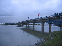
- No. 2 Road Bridge
-
No. 2 Road Bridge 
Carries Four lanes of No. 2 Road, pedestrians and bicycles Crosses Middle Arm Fraser River Locale Richmond Maintained by City of Richmond Design girder bridge Total length 560 m Width 22 m Opened 1993 Coordinates 49°10′34.74″N 123°9′25.03″W / 49.1763167°N 123.1569528°WCoordinates: 49°10′34.74″N 123°9′25.03″W / 49.1763167°N 123.1569528°W The No. 2 Road Bridge is a low-level four-lane bridge in Richmond, British Columbia, Canada. It connects Sea Island, where the Vancouver International Airport is located, to the west part of Richmond on Lulu Island. For west Richmond residents who drive to work in Vancouver, this bridge is the route of choice, replacing the role held previously by the Dinsmore Bridge.
The bridge's span starts as No. 2 Road on Lulu Island and turns into Russ Baker Way on Sea Island. The site of the speed-skating oval for the 2010 Winter Olympics in Vancouver, the Richmond Olympic Oval, is located at the southern foot of the bridge, to the east.
See also
Bridges and tunnels in Metro Vancouver Road bridges 204th Street Overpass • Alex Fraser Bridge • Arthur Laing Bridge • Burrard Bridge • Cambie Bridge • Coast Meridian Overpass • Deering Island Bridge • Dinsmore Bridge • Dollarton Bridge • Eleanor Ward Bridge • Georgia Viaduct • Golden Ears Bridge • Granville Street Bridge • Ironworkers Memorial Second Narrows Crossing • Knight Street Bridge • Lions Gate Bridge • Moray Bridge • No. 2 Road Bridge • Oak Street Bridge • Pattullo Bridge • Pitt River Bridge • Port Mann Bridge • Queensborough Bridge • Sea Island Connector • Westham Island BridgeRoad-rail bridges Rail bridges Annacis Bridge • CNR Bridge • Marpole Bridge • New Westminster Bridge • Pitt River Swing Bridge • Second Narrows BridgePedestrian bridges Capilano Suspension Bridge • Lynn Canyon Suspension Bridge • Patricia Avenue Bridge • North Arm BridgeRoad tunnels Rail tunnels Rapid transit BridgesTunnelsCrossings of the Fraser River Upstream
Dinsmore BridgeNo. 2 Road Bridge Downstream
Strait of GeorgiaCategories:- Bridges in Vancouver
- Buildings and structures in Richmond, British Columbia
- Bridges over the Fraser River
- Road bridges in British Columbia
- Canadian bridge (structure) stubs
- Greater Vancouver stubs
Wikimedia Foundation. 2010.
