Moray Bridge

Moray Bridge
Moray Bridge
Official name Moray Channel Bridge
Carries Two lanes of Sea Island Way, pedestrians and bicycles
Crosses Middle Arm Fraser River
Locale Richmond
Maintained by City of Richmond
Design swing bridge
Opened 1957
Coordinates 49°11′30″N 123°08′10″W / 49.191612°N 123.136128°W / 49.191612; -123.136128Coordinates: 49°11′30″N 123°08′10″W / 49.191612°N 123.136128°W / 49.191612; -123.136128
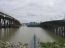
The Moray Bridge (right) beside its twin, the Sea Island Bridge (left).

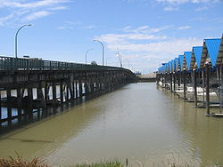
Moray Bridge, originally christened 'The Middle-arm Swing Bridge' in October 1957, is a low-level one-way swing bridge in Richmond, British Columbia, Canada. It connects Grant McConachie Way on Sea Island, where the Vancouver International Airport is located, with Sea Island Way on Lulu Island. The bridge is also called the Moray Channel Bridge, and the swing section is 58 metres long.

The bridge handles eastbound traffic coming from Sea Island. It was a two-way bridge until the completion of the nearby Sea Island Bridge, which handles traffic towards Sea Island.

The bridge passes over the Middle Arm of the Fraser River (in a section referred to as the Moray Channel) and was previously frequently called the Middle Arm Bridge, a name now used by a Skytrain bridge.

See also


Wikimedia Foundation. 2010.

Игры ⚽ Нужно сделать НИР?

Look at other dictionaries:

  • Moray Firth — Fiordo (o estuario) de Moray (Moray Firth An Cuan Moireach Linne Mhoireibh) Vista de satélite de la parte norte de Gran Bretaña. El fiordo de Moray es el gran entrante localizado arriba a la derecha …   Wikipedia Español

  • Moray Firth — The Moray Firth /ˈmʌrifɜrθ/ (Scottish Gaelic: An Cuan Moireach or Linne Mhoireibh) is a roughly triangular inlet (or firth) of the North Sea, north and east of Inverness, which is in the Highland council area of north of Scotland. It is the… …   Wikipedia

  • Moray Firth — Lage des Moray Firth Der Moray Firth (Schottisch Gälisch: An Cuan Moireach oder Linne Mhoireibh) ist ein annähernd dreieckiger Meeresarm (engl. Firth), im deutschen auch Förde genannt, an der Nordseeküste der schottischen Highlands, nordöstlich… …   Deutsch Wikipedia

  • Dinsmore Bridge — Carries Two lanes of Gilbert Road, pedestrians and bicycles Crosses Middle Arm Fraser River Locale Richmond …   Wikipedia

  • Middle Arm Bridge — The Middle Arm Bridge. The Middle Arm Bridge is one of 3 transit only bridges in Metro Vancouver. It spans the middle arm of the Fraser River, linking Lulu Island with the Vancouver International Airport on Sea Island. It is used by the airport… …   Wikipedia

  • Sea Island Bridge — (officially known as the Airport Connector Bridge) is a low level three lane one way bridge in Richmond, British Columbia, Canada. It connects Bridgeport Road on Lulu Island with Grant McConachie Way on Sea Island, where the Vancouver… …   Wikipedia

  • Oak Street Bridge — Carries Four lanes of British Columbia Highway 99, pedestrians and bicycles Crosses North Arm Fraser River Locale …   Wikipedia

  • New Westminster Bridge — Fraser River Swing Bridge (below), as seen from the Skybridge. The New Westminster Bridge (also known as the Fraser River Swing Bridge) crosses the Fraser River and connects New Westminster with Surrey, British Columbia, in Canada …   Wikipedia

  • North Arm Bridge — The North Arm Bridge shot from a SkyTrain that has just left the bridge, in Richmond heading to Bridgeport Station. Carries Two tracks of the Canada Line and a pedestrian and bike pathway attached beneath and beside the tra …   Wikipedia

  • No. 2 Road Bridge — Carries Four lanes of No. 2 Road, pedestrians and bicycles Crosses Middle Arm Fraser River Locale Richmond …   Wikipedia

Share the article and excerpts

Direct link
Do a right-click on the link above
and select “Copy Link”