- Turners Falls Road Bridge
Infobox Bridge
bridge_name=Turners Falls Road Bridge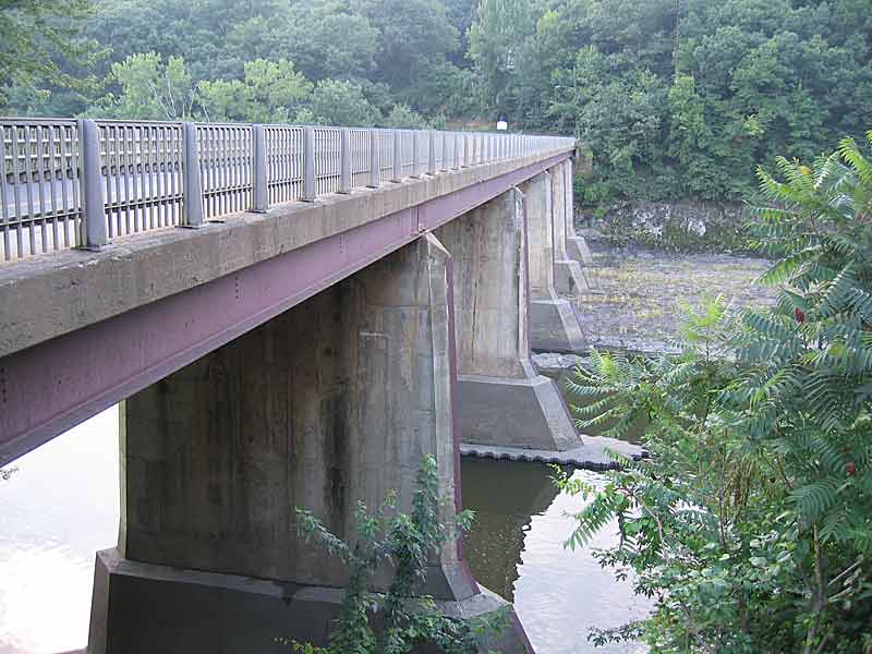
caption=Upstream side of the bridge with the river fully diverted away
official_name=White Bridge
carries=vehicular and pedestrian traffic
crosses=Connecticut River
locale=Greenfield and Montague, Franklin County,Massachusetts
maint=MassHighway
id=G1200212RMHDNBI
designer=
design=Stringer/Multi-beam or Girder
material=Steel (and concrete)
spans=6
pierswater=5
mainspan=
length=Convert|135.9|m|ft|1
width=Convert|6.1|m|ft|1
height=
load=51.5 metric tons
clearance=
below=
traffic=10,800 (2003)
begin=
complete=
open=1936
closed=
toll=
map_cue=
map_
map_text=
map_width=
coordinates=coord|42|36|33|N|72|33|41|W|region:US_type:landmark|display=inline,title|name=Turners Falls road bridge
lat=
long= The Turners Falls Road Bridge (officially White Bridge) is a concrete and steel road bridge over theConnecticut River in theU.S. state ofMassachusetts . It carries Turners Falls Road and connects the town center of Greenfield and the village of Turners Falls (in the town of Montague).History
The current bridge is the second on this site. Previously, a suspension bridge constructed in 1871 and known as the "Lower Suspension Bridge" was located at the site.cite book
last = Whittlesey
first = Charles W.
authorlink =
coauthors =
title = Crossing and Re-Crossing the Connecticut River
publisher = The Tuttle, Morehouse & Taylor Company
date = 1938
location = New Haven, Connecticut
pages = p.25
url =
doi =
id =
isbn = ] The old bridge was constructed with funds from the towns of Greenfield and Montague and cost about $36,000. [http://books.google.com/books?id=sh9CqaP8bkEC&pg=PA31 P.S. Miller and K.J. Scott, "Montague"] , (Arcadia, 2000)] A road connecting the bridge to Greenfield center was laid out by the following year. [http://books.google.com/books?id=9scMAAAAYAAJ&pg=PA406 F.M. Thompson, L.J.C. Kellogg, and C.S. Severance, "History of Greenfield"] , (T. Morey and Son, 1954)] The bridge was constructed primarily to allow laborers in Greenfield to easily go to the newly developing village of Turners Falls. The previous bridge was severely damaged in the 1936 flood and the current bridge was constructed soon after.In the 1920s, Route 2 (former
New England Route 7 ) originally left Greenfield via Turners Falls Road, crossing the old suspension bridge into the village of Turners Falls. Route 2 left Turners Falls via Millers Falls Road. In 1932, a more modern bridge capable of handling the increased automobile traffic, theFrench King Bridge , opened further upstream and Route 2 was relocated to its modern alignment along French King Highway. [ [http://www.mhd.state.ma.us/default.asp?pgid=bridge/frenchking&sid=bridgeData Massachusetts Highway Department, French King Bridge] ] The former alignment through Turners Falls was designated as Route 2A. The Route 2A designation remained on Turners Falls Road until the 1960s. [Topographic maps show the Route 2A still marked in 1954. A 1972 map no longer shows Route 2A through Turners Falls.]See also
*
List of crossings of the Connecticut River References
* [http://nationalbridges.com/nbi_record.php?StateCode=25&struct=G1200212RMHDNBI Bridge Inventory Data] on NationalBridges.com
Footnotes
External links
* [http://www.memorialhall.mass.edu/collection/itempage.jsp?itemid=15763&
]
Crossings navbox
structure = Crossings
place =Connecticut River
bridge = Turners Falls Road Bridge
bridge signs =
upstream =Gill - Montague Bridge
upstream signs =
downstream =General Pierce Bridge
downstream signs =
Wikimedia Foundation. 2010.