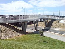
- Onehunga Harbour Road Bridge
-
The Onehunga Harbour Road Bridge is a walking and cycling bridge over Onehunga Harbour Road, a heavily trafficked road at the southwestern edge of Onehunga, New Zealand. The bridge provides easy and safe access from Onehunga to both the Waikaraka Cycleway running west-east, and Old Mangere Bridge to the south, which in turn links over the Mangere Inlet mouth of the Manukau Harbour.[1] The bridge is 3.5m wide, and distinguished by its sweeping, curved structure.[2]
History
The crossing of Onehunga Harbour Road was historically very difficult, as traffic was fast and heavy with over 15,000 vehicles daily[2] (due to the nearby port and the motorway ramps) and sight distances were also limited by the strong curve of the road in the vicinity.
The design of the bridge was developed in communication with local community groups and the cycling advocate group Cycle Action Auckland,[3] as an ancillary project to the State Highway 20 duplication of the nearby Mangere Bridge motorway bridge.[1] It was completed in 2010, with the construction team having to overcome various issues with difficult ground, some of the piles having to be sunk up to 30m deep through volcanic deposits to local sandstone bedrock.[2] A nearby underpass under SH20, connecting on from the bridge to Onehunga, was also upgraded as part of the project.[1]
See also
- Mangere Bridge (bridges)
- Waikaraka Cycleway
References
- ^ a b c "Bridge offers safe access between suburbs". The New Zealand Herald. 20 April 2010. http://www.nzherald.co.nz/onehunga/news/article.cfm?l_id=353&objectid=10639471. Retrieved 30 January 2011.
- ^ a b c "New pedestrian/cycle bridge provides safe Manukau access". New Zealand Transport Agency press release. 1 December 2010. http://www.nzta.govt.nz/about/media/releases/982/news.html. Retrieved 30 January 2011.
- ^ "Manukau Harbour Crossing Newsletter". New Zealand Transport Agency. April 2010. http://www.nzta.govt.nz/projects/mhc/resources/pdf/newsletter-201004.pdf. Retrieved 9 July 2010.
Coordinates: 36°55′53″S 174°47′11″E / 36.931485°S 174.78629°E
Categories:- Bridges in Auckland
- Pedestrian bridges
- Cyclist bridges
- New Zealand building and structure stubs
- Bridge (structure) stubs
Wikimedia Foundation. 2010.

