- Xangongo
-
Xangongo — Municipality and town — 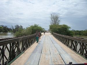 Location in Angola
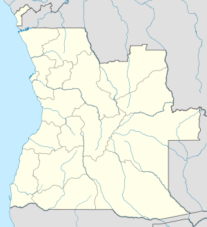
 Xangongo
Coordinates: 16°44′48″S 14°58′29″E / 16.74667°S 14.97472°E Country  Angola
Province Cunene Province Time zone WAT (UTC+1) Xangongo is a town in Cunene Province, Angola. It is located at around 16°44′48″S 14°58′29″E / 16.74667°S 14.97472°ECoordinates: 16°44′48″S 14°58′29″E / 16.74667°S 14.97472°E. It was also the site of considerable fighting in the war for the independence of Namibia (Southwest Africa) and the Angolan Civil War.
Xangongo and SWAPO
Xangongo was the headquarters of SWAPO's "northwestern front." A South African military operation called "Operation Protea" occurred on August 23, 1981. Its aim was to destroy SWAPO in the Angolan towns of Xangongo and Ongiva. It was very successful and significantly boosted the South African military operations against both SWAPO and the Angolan military. The bridge over the Cunene River was destroyed by SADF Special Forces and the town was held for many years by South Africa[1]. At the end of the Battle of Cuito Cuanavale the Fidel Castro 50th Brigade moved in and started harassing the withdrawing SADF forces, triggering Operation Hilti/Excite[2]. In response to this harassment the SADF mobilized 81 Armoured Brigade in Operation Desert Fox, designed to neutralize the Cuban 50th Division[3], but this was not necessary because of the successful negotiations that ended the South African involvement in the Angolan Civil War[4].
References
- ^ Turton, A.R. 2010. Shaking Hands with Billy. Durban: Just Done Publications. http://www.shakinghandswithbilly.com
- ^ Nortje, P. 2003. 32 Batallion. Cape Town: Struik Publishers.
- ^ Ramsden, Tim. 2009. Border-Line Insanity: A National Serviceman’s Story. Alberton: Galago.
- ^ Turton, A.R. 2010. Shaking Hands with Billy. Durban: Just Done Publications. http://www.shakinghandswithbilly.com
Transport
The area is served by Xangongo Airport.
 Municipalities of Angola
Bengo Province Benguela Province Bié Province Cabinda Province Cuando Cubango Province Cuanza Norte Province Ambaca · Banga · Bolongongo · Bula Atumba · Cazengo · Cambambe · Dembos · Golungo Alto · Gonguembo · Lucala · N'dalatando · Pango Aluquem · Quiculungo · Samba CajuCuanza Sul Province Amboim · Cassongue · Cela (Waku-Kungo) · Conda · Ebo · Libolo · Mussende · Porto Amboim · Quibala · Quilenda · Seles · SumbeCunene Province Huambo Province Huíla Province Luanda Province Lunda Norte Province Capemba-Camulemba · Caumbo · Caungula · Chitato-Dundo · Cuango · Cuilo · Dundo · Lubalo · Lucapa · Xa-MutebaLunda Sul Province Malanje Province Cacuzo · Calandula · Cambundi-Catembo · Caombo · Cuaba Nzogo · Cunda-dia-Baza · Luquembo · Malanje · Marimba · Massango · Mucari · Quela · Quirima CangandalaMoxico Province Namibe Province Uíge Province Zaire Province Categories:- Populated places in Angola
- Municipalities of Angola
- Cunene Province
- Angola geography stubs


Wikimedia Foundation. 2010.