- Chipindo
-
Chipindo — Municipality and town — 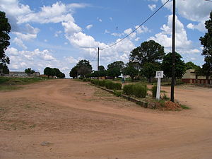 Location in Angola
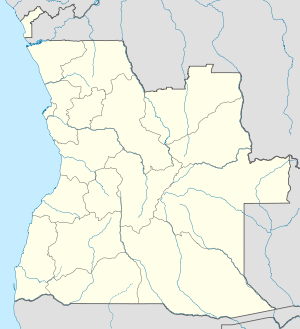
 Chipindo
Coordinates: 13°49′28″S 15°48′0″E / 13.82444°S 15.8°ECoordinates: 13°49′28″S 15°48′0″E / 13.82444°S 15.8°E Country  Angola
Province Huíla Province Area - Total 1,505 sq mi (3,898 km2) Population (2006)Instituto Nacional de Estatística, Angola. Instituto Nacional de Segurança Social, Angola. - Total 33,244 - Density 41.4/sq mi (16/km2) Time zone WAT (UTC+1) Chipindo is a town and municipality in Huíla Province in Angola.[1], situated 450 km North of Lubango, Huila province capital.
Contents
Geography & Territory
With an extension of 3.898 km2, and a density of population of 16 inhabitants per km2, it is limited with the towns of Caála and Tchicala Tcholoanga in Huambo Province in the North, with Jamba town in the South, with Kuvango in the East and with Caconda and Chicomba in the West.
Its population is estimated in 33.244 inhabitants (2.006).[2], distributed in two comunas, Chipindo Sede and Bambi, that are constituited by seven regedorías, Tchitata, Camoanha, Sangueve, Capembe e Bundjei (Chipindo Sede), Catapua, Bambi sede (Bambi), and a great number of aldeias in each comuna. During the raining season traffic is strongly reduced due to the bad shape of the roads.
It has a small landing runway.
Weather
It has a tropical arid weather, with two differentiated seasons, raining season from September to April and dry season from May to August with low temperatures.
Population
Mother tongue of most of the population is Umbundu, spoken by the majority of Umbundu people, although it exist a part of the population belonging to Gangela people, especially in the West, close to Kuvango. The population is in its majority of strong traditional beliefs.
Administration
Since the end of the war, for the first time in 14 years, since March 19th, 2002, a local administration was stablished.
COMUNAS
- CHIPINDO SEDE: town center. Local Administration, police, Catholic church, Health center, School and Hospital (under construction in 2004). Aldea de Mbuandangui: 2 km from Chipindo sede, Action Against Hunger base (as of 2005). Regidurias: Sangueve, Camoanha, Tchitata, Capembe and Bundjei.
- BAMBI: South of the town. Health post.
Regidurias: Catapua, Bambi sede.
SECTOR
- Bundjei: North of the town. Health center.
References
- ^ "City councils of Angola". Statoids. http://www.statoids.com/yao.html. Retrieved April 9, 2009.
- ^ http://www.xist.org/cntry/angola.aspx?levels=Huila Instituto Nacional de Estatística, Angola. Instituto Nacional de Segurança Social, Angola
 Municipalities of Angola
Bengo Province Benguela Province Bié Province Cabinda Province Cuando Cubango Province Cuanza Norte Province Ambaca · Banga · Bolongongo · Bula Atumba · Cazengo · Cambambe · Dembos · Golungo Alto · Gonguembo · Lucala · N'dalatando · Pango Aluquem · Quiculungo · Samba CajuCuanza Sul Province Amboim · Cassongue · Cela (Waku-Kungo) · Conda · Ebo · Libolo · Mussende · Porto Amboim · Quibala · Quilenda · Seles · SumbeCunene Province Huambo Province Huíla Province Luanda Province Lunda Norte Province Capemba-Camulemba · Caumbo · Caungula · Chitato-Dundo · Cuango · Cuilo · Dundo · Lubalo · Lucapa · Xa-MutebaLunda Sul Province Malanje Province Cacuzo · Calandula · Cambundi-Catembo · Caombo · Cuaba Nzogo · Cunda-dia-Baza · Luquembo · Malanje · Marimba · Massango · Mucari · Quela · Quirima CangandalaMoxico Province Namibe Province Uíge Province Zaire Province Categories:- Angola geography stubs
- Populated places in Angola
- Municipalities of Angola
- Huíla Province


Wikimedia Foundation. 2010.