- Ostbevern
-
Ostbevern 

 OstbevernLocation of Ostbevern within Warendorf district
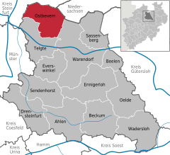

Coordinates 52°2′20″N 7°50′45″E / 52.03889°N 7.84583°ECoordinates: 52°2′20″N 7°50′45″E / 52.03889°N 7.84583°E Administration Country Germany State North Rhine-Westphalia Admin. region Münster District Warendorf Municipal subdivisions 2 Mayor Jürgen Hoffstädt (CDU) Basic statistics Area 89.44 km2 (34.53 sq mi) Elevation 54 m (177 ft) Population 10,569 (31 December 2010)[1] - Density 118 /km2 (306 /sq mi) Other information Time zone CET/CEST (UTC+1/+2) Licence plate WAF Postal code 48346 Area code 02532 Website www.ostbevern.de Ostbevern is a municipality in the district of Warendorf, in North Rhine-Westphalia, Germany.
Contents
Geography
Ostbevern is situated on the river Bever, approx. 18 km north-east of Münster and 18 km north-west of Warendorf.
Neighbouring municipalities
Ostbevern borders Ladbergen, Lienen, Glandorf (in Lower Saxony), Warendorf, Telgte und Greven.
Division of the town
The municipality Ostbevern consists of the village Ostbevern, the district Brock and the surrounding farming land.
History
In 1088 Bevern was first mentioned in an official document under the name Beverne. Presumably in the 12th century the parish Bevern was split into Ostbevern and Westbevern (which is now part of Telgte).
During the Napoleonic Wars the municipality first fell to Prussia, then to Berg. Since 1810 it then belonged to the French Empire, until Ostbevern was assigned to prussia again at the Congress of Vienna. Since World War II Ostbevern lies in North Rhine-Westphalia.
Politics
Communal Politics
The communal politics are dominated by the CDU, who have the absolute majority in the Municipal council. After the local elections of 2004, the 26 seats of the municipal council are distributed like this:
- CDU: 14 seats
- FDP: 4 seats
- SPD: 4 seats
- Green Party: 4 seats
Twin Towns
Ostbeverns twins the city Loburg in Saxony-Anhalt.
Economy
The economy in Ostbevern is characterized by agriculture and processing business. The CEAG AG / FRIWO Group has its headquarters in Ostbevern.
Tourist attractions
The Ambrose-church consist of a big new part, built in 1962 a smaller gothic church built in the 16th century. Parts of the church steeple are from the 12th century.
Another beautiful sight is the moated castle Loburg, in which there is today an episcopal school.
References
- ^ "Amtliche Bevölkerungszahlen" (in German). Landesbetrieb Information und Technik NRW. 31 December 2010. http://www.it.nrw.de/statistik/a/daten/amtlichebevoelkerungszahlen/index.html.
External links
- Website of the municipality Ostbevern (German)
- Local heritage book Ostbevern (German)
- Friwo company website
Ahlen | Beckum | Beelen | Drensteinfurt | Ennigerloh | Everswinkel | Oelde | Ostbevern | Sassenberg | Sendenhorst | Telgte | Wadersloh | Warendorf Categories:
- Municipalities in North Rhine-Westphalia
- North Rhine-Westphalia geography stubs


Wikimedia Foundation. 2010.