- Oelde
-
Oelde 
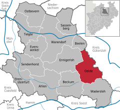
Coordinates 51°49′33″N 8°08′37″E / 51.82583°N 8.14361°ECoordinates: 51°49′33″N 8°08′37″E / 51.82583°N 8.14361°E Administration Country Germany State North Rhine-Westphalia Admin. region Münster District Warendorf Town subdivisions 5 Mayor Karl-Friedrich Knop (FW) Basic statistics Area 102.63 km2 (39.63 sq mi) Elevation 74 - 173 m Population 29,276 (31 December 2010)[1] - Density 285 /km2 (739 /sq mi) Other information Time zone CET/CEST (UTC+1/+2) Licence plate WAF Postal code 59302 Area codes 02522, 02529, 02520, 05245 Website www.oelde.de Oelde (German pronunciation: [ˈœldə]) is a town in the district of Warendorf, in North Rhine-Westphalia, Germany. It is located near Beckum.
Contents
Geography
Division of the town
Oelde consists of 5 districts:
- Oelde
- Stromberg
- Lette
- Sünninghausen
- Kirchspiel (with farming communities)
- Keitlinghausen
- Ahmenhorst
- Menninghausen
Neighbouring places
International relations
Oelde is twinned with:
History
Records from the 9th century show that there was a settlement named "Ulidi" on the site, although Oelde only received township in the year 1800. In the 14th century, a castle was built in Oelde.
Economy
Oelde is a centre of metal and lumber production, publishing, and also higher education through its nursing college. It is also home to the headquarters of Westfalia Separator, a manufacturer of centrifuges and dairy machines.
References
- ^ "Amtliche Bevölkerungszahlen" (in German). Landesbetrieb Information und Technik NRW. 31 December 2010. http://www.it.nrw.de/statistik/a/daten/amtlichebevoelkerungszahlen/index.html.
External links
- Official site (German)
Ahlen | Beckum | Beelen | Drensteinfurt | Ennigerloh | Everswinkel | Oelde | Ostbevern | Sassenberg | Sendenhorst | Telgte | Wadersloh | WarendorfCategories:- Towns in North Rhine-Westphalia
- North Rhine-Westphalia geography stubs
Wikimedia Foundation. 2010.


