- Cotentin Peninsula
-
The Cotentin Peninsula, also known as the Cherbourg Peninsula, is a peninsula in Normandy, forming part of the north-western coast of France. It juts out north-westwards into the English Channel, towards Great Britain. To its west lie the Channel Islands and to the southwest lies the Brittany Peninsula.
The peninsula lies wholly within the département of Manche, in the région of Basse-Normandie.
Contents
Geography
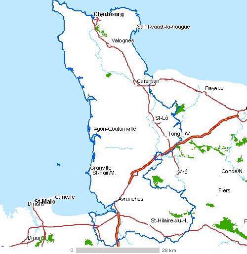
It is part of the Armorican Massif and lies between the estuary of the Vire River and Mont Saint Michel Bay. It is divided into three areas: the headland of La Hague, the Cotentin Pass, and the valley of the Saire River (Val-de-Saire). It forms the bulk of the Manche département.
The largest town in the peninsula is Cherbourg on the north coast, a major cross-channel port. Other towns of note: Coutances, Barfleur, Saint-Lô, Bricquebec, Granville, Barneville-Carteret, Carentan, Avranches.
The western coast of the peninsula, known as la Côte des Îles (the coast of the islands) faces the Channel Islands and ferry links serve Carteret, Granville and the islands (including Chausey). Off the east coast of the peninsula lie the island of Tatihou and the Îles Saint-Marcouf.
History
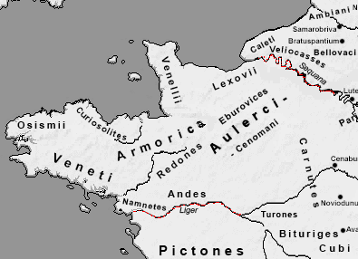
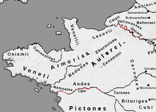 Roman Armorica
The peninsula formed part of the Roman geographical area of Armorica. The town known today as Coutances, capital of the Unelli, a Gaulish tribe, acquired the name of Constantia in 298 during the reign of Roman emperor Constantius Chlorus. The base of the peninsula, called in Latin the pagus Constantinus, joined together with the pagus Coriovallensis centred upon Cherbourg to the north, subsequently became known as the Cotentin. Under the Carolingians it was administered by viscounts drawn successively from members of the Saint-Sauveur family, at their seat Saint-Sauveur on the Douve.[1]
The migration of Vikings in the ninth century led to the area becoming part of the territory of the Northmen, or Normans, creating Normandy, in the early tenth century. This resulted in a number of placenames which were derived from the Norse. Examples include La Hague, and La-Hougue both derived from the Old Norse word haugr meaning a hill or mound.[2]
Until the construction of modern roads, the peninsula was almost inaccessible in winter due to the band of marshland cutting off the higher ground of the promontory itself. This explains occasional historical references to the Cotentin as an island.
In 1088 Robert Curthose, Duke of Normandy, enfeoffed the Cotentin to his brother Henry, later King Henry I of England, who as count of the Cotentin established his first power base there and in the adjoining Avranchin, which lay to the south, beyond the River Thar, among the region's lords, abbots and bishops.[3]
The town of Valognes was, until the French Revolution, a provincial social resort for the aristocracy, nicknamed the Versailles of Normandy. Little remains of the grand houses and châteaux as a result of the destruction of the Battle of Normandy. The social scene was described in the novels of Jules Barbey d'Aurevilly (himself from the Cotentin).
The Battle of La Hougue took place in 1692 at Saint-Vaast-la-Hougue near Barfleur.
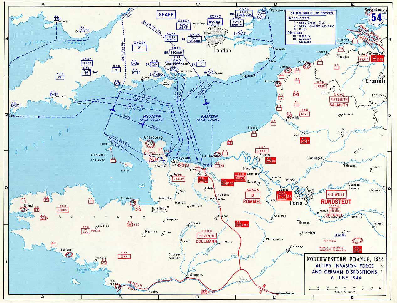
In the Second World War, a significant portion of the Battle of Normandy, through the summer of 1944, was fought in the area, which was the site of Operation Overlord, known as the "Normandy landings", from which the Allies launched the liberation of Western Europe. Utah Beach, one of the invasion landing beaches, was on the eastern coast of the peninsula. The peninsula's river- and canal-crossed agricultural terrain suffered during the next months fighting as the allies sought to break out of their lodgement.
Economy
The main economical resource is agriculture. Dairy farming is an a prominent activity. Along the west coast, renowned vegetables are grown (carrots of Créances).
The region is also famous for its shellfish culture, like the oysters from Saint-Vaast-la-Hougue and Pirou, and the manufacturing of alcoholic beverages like cider and calvados, made from local grown apples and pears.
The region hosts two important nuclear power facilities. At Flamanville there is a nuclear power plant, where the second European Pressurized Reactor in the world is being constructed, with commissioning planned for 2012. COGEMA La Hague site, a large nuclear waste reprocessing and storage complex operated by Areva NC, is located a few miles to the north, at Beaumont-Hague. The facility stores all high level waste from the French nuclear power program in one large vault. Nuclear industry provides a substantial portion of jobs in the region. The roads used for transport of nuclear waste have been blocked many times in the past by environmental action group Greenpeace. Local environmental groups have voiced concerns about the radioactivity levels of the cooling water of both these nuclear sites, which is being flushed into the bay of Vauville; however, the emitted radioactivity is several orders of magnitude below natural background levels and does not pose any hazard.
Tourism is also an important economic activity in this region. Many tourists visit the D-Day invasion beaches, the paratrooper linked town of Sainte-Mère-Église, the American war cemetery at Colleville-sur-Mer and the German war cemetery at La Cambe.
Culture
After quitting political life, the political thinker Alexis de Tocqueville retreated to the family estate of Tocqueville where he wrote much of his work.
Due to its comparative isolation, the peninsula is one of the remaining strongholds of the Norman language, and the local dialect is known as Cotentinais. The Norman language poet Côtis-Capel described the environment of the peninsula, while French language poet Jacques Prévert made his home at Omonville-la-Petite. The painter Jean-François Millet was born in the peninsula, as well as Allain Leprest, a great modern French poet and songwriter.
The Norman language writer Alfred Rossel, native of Cherbourg, composed many songs which form part of the heritage of the region. Rossel's song Sus la mé ("on the sea") is often sung as a regional patriotic song.
References
- ^ P. Chesnel, Le Cotentin et l'Avranchin sous les ducs de Normandie, 911-1204, 1912, noted in [[C. Warren Hollister, Henry I (Yale English Monarchs), 2001:51ff and map, xviii; there were two brief interludes when it was declared a countship.
- ^ Twelve essential old Scandinavian words (old Norse) in placenames of Normandy (R. Lepelley. Caen University)
- ^ Hollister 2001: ff.
Other sources
- Renaud, Jean Les Vikings et la Normandie (Ouest-France. 2002) ISBN/ISSN : 2-7373-0258-7
- Renaud, Jean Les dieux des Vikings (Ouest-France. 2002) ISBN/ISSN : 2-7373-1468-2
Footnotes
- ^ P. Chesnel, Le Cotentin et l'Avranchin sous les ducs de Normandie, 911-1204, 1912, noted in [[C. Warren Hollister, Henry I (Yale English Monarchs), 2001:51ff and map, xviii; there were two brief interludes when it was declared a countship.
- ^ Twelve essential old Scandinavian words (old Norse) in placenames of Normandy (R. Lepelley. Caen University)
- ^ Hollister 2001: ff.
Wikimedia Foundation. 2010.