- Korea Bay
-
Korea Bay 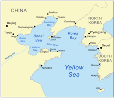
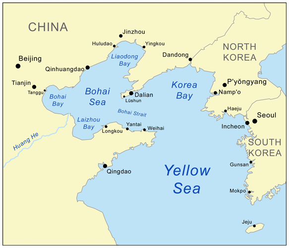
Map showing Korea Bay.North Korean name Chosŏn'gŭl 서조선만 Hancha 西朝鮮灣 McCune-Reischauer Sŏjosŏn-man Revised Romanization Seojoseon-man South Korean name Hangul 서한만 Hanja 西韓灣 Revised Romanization Seohan-man McCune-Reischauer Sŏhan-man The Korea Bay (simplified Chinese: 朝鲜湾; traditional Chinese: 朝鮮灣; pinyin: Cháoxiǎn Wān, Korean 서조선만, Korean pronunciation: [sʌ.dʑo.sʌn.man], meaning "West Korea Bay") is a northern extension of the Yellow Sea,[1] between Liaoning Province of China and North P'yŏngan Province of North Korea.[2]
It is separated from the Bohai Sea by the Liaodong Peninsula, with Dalian at its southernmost point. [3][4]
The Yalu (Amnok) River, which marks the border between China and North Korea, empties into the Korea Bay between Dandong (China) and Sinŭiju (North Korea).[5][6]
See also
Notes
- ^ Merriam-Webster's Geographical Dictionary, Third Edition. Springfield, Mass.: Merriam-Webster. 1998. p. 605. ISBN 0877795460.
- ^ Merriam-Webster's Geographical Dictionary, Third Edition. Springfield, Mass.: Merriam-Webster. 1998. p. 606. ISBN 0877795460.
- ^ Merriam-Webster's Geographical Dictionary, Third Edition. Springfield, Mass.: Merriam-Webster. 1998. p. 647. ISBN 0877795460.
- ^ Merriam-Webster's Geographical Dictionary, Third Edition. Springfield, Mass.: Merriam-Webster. 1998. p. 300. ISBN 0877795460.
- ^ Merriam-Webster's Geographical Dictionary, Third Edition. Springfield, Mass.: Merriam-Webster. 1998. p. 1321. ISBN 0877795460.
- ^ Merriam-Webster's Geographical Dictionary, Third Edition. Springfield, Mass.: Merriam-Webster. 1998. p. 1092. ISBN 0877795460.
Notable Bays of China Bohai Bay • Bohai Economic Rim • Bohai Sea • Dalian Bay • Daya Bay • Haitang Bay • Hangzhou Bay • Jiaozhou Bay • Korea Bay • Laizhou Bay • Liaodong Bay • Mirs Bay • Sanya Bay • Yalong BayCategories:- Yellow Sea
- Landforms of North Korea
- Bays of China
- China–North Korea border
- North Korea geography stubs
- People's Republic of China geography stubs
Wikimedia Foundation. 2010.