- Chongzuo
-
Chongzuo
崇左
Cungzcoj— Prefecture-level city — 崇左市 Location of Chongzuo Prefecture within Guangxi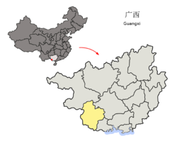 Location of Chongzuo Prefecture within Guangxi
 Chongzuo
Coordinates: 22°25′N 107°22′E / 22.417°N 107.367°E Country China Province Guangxi Area - Total 6,696.9 sq mi (17,345 km2) Population (2004) - Total 2,260,000 Time zone China standard time (UTC+8) Postal code 532200 Area code(s) 771 Website http://www.chongzuo.gov.cn/ Chongzuo (Chinese: 崇左; pinyin: Chóngzuǒ; Zhuang: Cungzcoj) is a prefecture-level city in China's Guangxi Zhuang Autonomous Region. It is home to one of China’s largest Zhuang populations.
Contents
Geography and climate
Chongzuo is located in southwestern Guangxi province. It borders Nanning in the east, Baise in the north, Fangchenggang in the south and Lạng Sơn, Vietnam in the west. The Zuo or Left River and the You or Right River have their confluence in Chongzuo after which the river becomes the Yong River. Chongzuo is mountainous and hilly with numerous karst formations similar to Guilin and northern Vietnam’s Ha Long Bay. Its area is 17,345 km², 7,190 km² of which is forested.
Chongzuo’s climate is tropical wet. January’s average temperature is 13.8o C and July’s is 28.1o C. Annual average is 20.8-22.4o C. There are 330 frost free days. Annual precipitation is between 1088-1799mm.
History
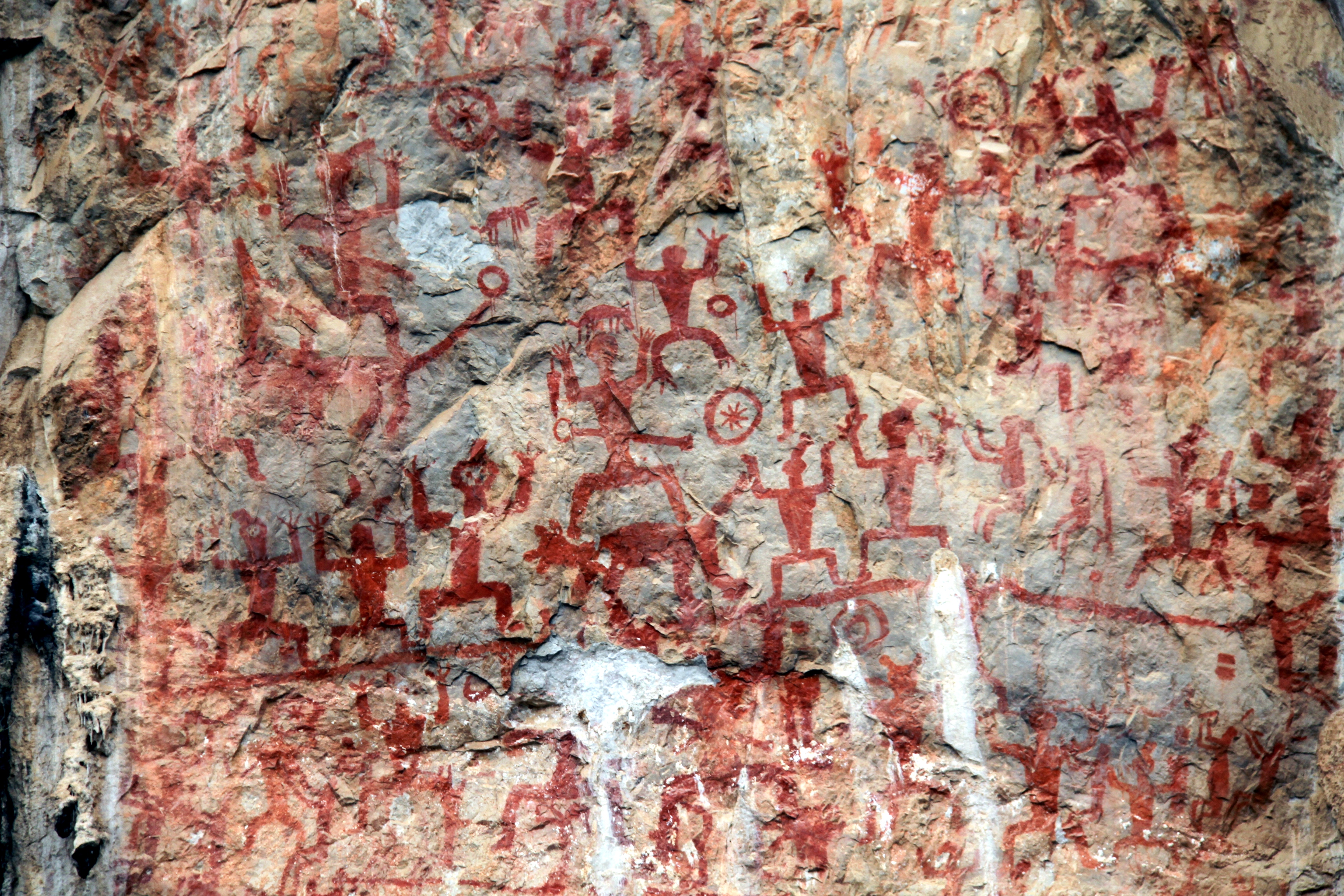
 Rock Paintings of Hua Mountain
Chongzuo is one of the earliest centers of Zhuang culture. Important sites dating back to the stone age have been found here. The Rock Paintings of Hua Mountain along the Ming River at Huashan date back 1800 to 2500 year and are one of the largest groups of pictographs in China and in the world. On several cliff faces are hundreds of large red pictographs depicting a large battle. The red pigment is still bright and vivid and individual figures, weapons, and animals are easy to distinguish. The cliffs, part of the sacred Frog Mountain, were important site to the early Zhuang.
In 214 BC, during the Qin dynasty, Chongzuo was part of the Xiang (象郡) commandry. Chinese general Feng Zicai (馮子才) beat back a French attack here at the Battle of Bang Bo in 1885. Sun Yat-sen (孫中山) fired the first cannon shot of the anti-Qing revolution in Chongzuo in 1907. In the 1930s, after fomenting rebellion in other parts of Guangxi, Deng Xiaoping (鄧小平) helped organize the peasants and workers here during the Longzhou rebellion and eventually formed the Red Army's 8th Army. Later, in 1979, the Chinese army invaded Vietnam from here.
Administration
Chongzuo has 1 district, 1 city, 5 counties, 57 towns, 72 townships, 146 residential communities, and 1,724 villages.
District:
- Jiangzhou District
City:
- Pingxiang (凭祥市)
Counties:
- Ningming County (宁明县)
- Longzhou County (龙州县)
- Fusui County (扶绥县)
- Daxin County (大新县)
- Tiandeng County (天等县)
Demographics
Chongzuo's population is 2,260,000. 88% of the people belong to the Zhuang ethnic group. The rest include Han, Yao, and other ethnic groups.
Economy
Forestry and agriculture are two of Chongzuo’s biggest industries. Oranges, rice, beans, corn, cassava, cinnamon, bananas, vegetables, durian, pineapples, longan, and tea are all major crops, but sugarcane is the center of Chongzuo agriculture. Farm raised animals include beef and dairy cattle, sheep, ducks, chickens, geese, and bees. Aquaculture for fish is also big. Chinese medicinal herbs are picked from the wild and also grown. Important mineral resources include manganese, gold, ferberite, coal, barite, bentonite, uranium, and vanadium. It is China’s biggest manganese producer and the world's biggest producer of bentonite. Other industries include export infrastructure, paper, forest products such as timber and turpentine, building materials, pharmaceuticals, and electronics manufacturing.
Flora and fauna
Chongzuo has amazing biodiversity with more than 4000 species of plants and more than 450 kinds of animals. There are more than 30 rare and protected animals including white headed and Indo-Chinese black langurs, crested striped hornbills, pangolins, and clouded leopards. 1/4 of China’s wild animal species can be found in Chongzuo.
Tourism
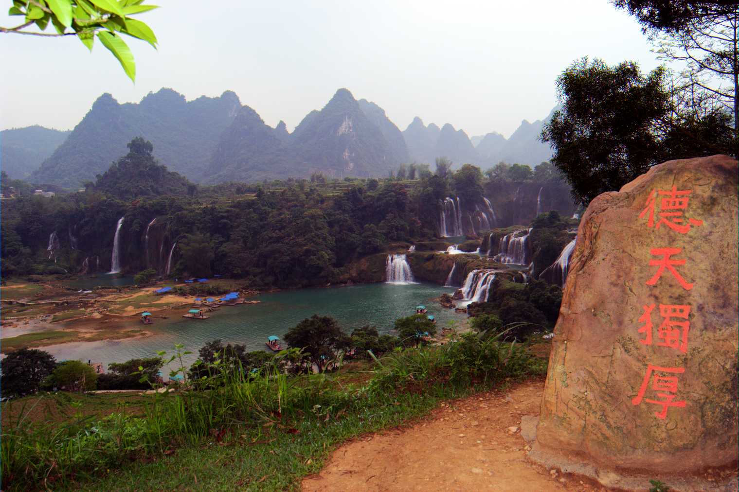
 View from China in dry season. Banyue fall is on the left. Detian is on the right
Chongzuo is famous for its beautiful natural scenery. The most famous attraction is Detian Waterfall in Daxing County along the border with Vietnam. It is the second largest waterfall along a national border after Niagara Falls and was one of the crossing points for China’s army during the brief Sino-Vietnamese War. Nearby there is the Tongling Gorge accessible only through a cavern from an adjoining gorge. Rediscovered only recently, it has many species of endemic plants, found only in the gorge, and used to be used as a hideout by local bandits whose treasure is occasionally still found in the cliff-side caves. West of Chongzuo city, there are several forest and animal preserves, some with minor tourist facilities.
See also
- Detian – Ban Gioc Falls
External links
- Official website (Chinese)
Guangxi topics Nanning (capital) General Geography Education Culture Cuisine Luosifen • TuotuorouVisitor attractions Guangxi Zhuang Autonomous Region county-level divisions Nanning (capital) Nanning: Qingxiu District · Xingning District · Xixiangtang District · Liangqing District · Jiangnan District · Yongning District · Wuming County · Long'an County · Mashan County · Shanglin County · Binyang County · Heng County Guangxi in China
Liuzhou: Chengzhong District · Yufeng District · Liubei District · Liunan District · Liujiang County · Liucheng County · Luzhai County · Rong'an County · Rongshui Autonomous County · Sanjiang Autonomous County
Guilin: Xiangshan District · Xiufeng District · Diecai District · Qixing District · Yanshan District · Yangshuo County · Lingui County · Lingchuan County · Quanzhou County · Pingle County · Xing'an County · Guanyang County · Lipu County · Ziyuan County · Yongfu County · Longsheng Autonomous County · Gongcheng Autonomous County
Wuzhou: Wanxiu District · Dieshan District · Changzhou District · Cenxi City · Cangwu County · Teng County · Mengshan County
Beihai: Haicheng District · Yinhai District · Tieshangang District · Hepu County
Fangchenggang: Gangkou District · Fangcheng District · Dongxing City · Shangsi County
Qinzhou: Qinnan District · Qinbei District · Lingshan County · Pubei County
Guigang: Gangbei District · Gangnan District · Qintang District · Guiping · Pingnan County
Yulin: Yuzhou District · Beiliu City · Rong County · Luchuan County · Bobai County · Xingye County
Baise: Youjiang District · Lingyun County · Pingguo County · Xilin County · Leye County · Debao County · Tianlin County · Tianyang County · Jingxi County · Tiandong County · Napo County · Longlin Autonomous County
Hezhou: Babu District · Zhongshan County · Zhaoping County · Fuchuan Autonomous County
Hechi: Jinchengjiang District · Yizhou City · Tian'e County · Fengshan County · Nandan County · Donglan County · Du'an Autonomous County · Luocheng Autonomous County · Bama Autonomous County · Huanjiang Autonomous County · Dahua Autonomous County
Laibin: Xingbin District · Heshan City · Xiangzhou County · Wuxuan County · Xincheng County · Jinxiu Autonomous County
Chongzuo: Jiangzhou District · Pingxiang City · Ningming County · Fusui County · Longzhou County · Daxin County · Tiandeng County■ = Prefecture-level city Categories:- Cities in Guangxi
- Prefecture-level divisions of Guangxi


Wikimedia Foundation. 2010.