- Mine, Yamaguchi
-
Mine
美祢市— City — Karst landscape of Akiyoshidai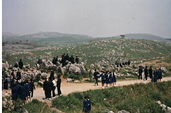 Location of Mine in Yamaguchi
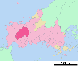

 Mine
MineCoordinates: 34°09′47″N 131°12′30″E / 34.16306°N 131.20833°ECoordinates: 34°09′47″N 131°12′30″E / 34.16306°N 131.20833°E Country Japan Region Chūgoku Prefecture Yamaguchi Government - Mayor Hiroshi Murata (since April 2008) Area - Total 472.71 km2 (182.5 sq mi) Population (May 1, 2011) - Total 28,392 - Density 60.06/km2 (155.6/sq mi) Time zone Japan Standard Time (UTC+9) City symbols - Tree Live oak - Flower Cherry blossom Phone number 81-(0)837-52-1111 Address Omine Higashiwake 326-1, Mine City, Yamaguchi Prefecture (山口県美祢市大嶺東分326番1号)
759-2292Website City of Mine Mine (美祢市 Mine-shi) is a city located in Yamaguchi, Japan.
Contents
History
The city was founded on March 31, 1954 by a merger of municipalities that departed from Mine District (Mine-gun).
On March 21, 2008, the city merged with the rest of Mine District, which consisted of towns Mitō and Shūhō, while the newly merged city retained the name, Mine.
Yamaguchi Prefecture consisted of seven counties which were integrated into the two provinces of Suō and Nagato in the 7th century. During the rise of the samurai class in the Heian and Kamakura Periods (794–1333), the Ouchi family of Suō Province and the Koto family of Nagato Province gained influence as powerful warrior clans. In the Muromachi Period (1336—1573), Ouchi Hiroyo, the 24th ruler of the Ouchi family conquered both areas of Yamaguchi Prefecture. The Ouchi clan imitated the city planning of Kyoto. They gained great wealth through cultural imports from the continent and trade with Korea and Ming Dynasty China. As a result, Yamaguchi came to be known as the "Kyoto of the West," and Ouchi culture flourished. Sue Harutaka defeated the 31st ruler of the Ouchi clan. The Sue clan was then defeated by Mōri Motonari, and the Mōri family gained control of the Chugoku region. Yamaguchi was ruled as part of the Mōri clan domain during the Sengoku period. Mōri Terumoto was then defeated by Tokugawa Ieyasu in the battle of Sekigahara in 1600. He was forced to give up all his land except for the Suō and Nagato areas (current-day Yamaguchi Prefecture), where he built his castle in Hagi. Mōri sought to strengthen the economic base of the region and increase local production with his Three Whites campaign (salt, rice, and paper).
After Commodore Matthew Perry's opening of Japan, clans from Nagato (also called Chōshū) played a key role in the fall of the Tokugawa shogunate and the establishment of the new imperial government. Four years after the Edo Shogunate was overthrown and the Meiji government formed in 1868, the present Yamaguchi Prefecture was established. The Meiji government brought in many new systems and modern policies, and promoted the introduction of modern industry, though the prefecture was still centered around agriculture during this period. In the Taisho period, from 1912 to 1926, shipbuilding, chemical, machinery, and metal working plants were built in Yamaguchi's harbors in the Seto Inland Sea area. During the post-World War II Shōwa Period, Yamaguchi developed into one of the most industrialized prefectures in the country due to the establishment of petrochemical complexes.[1][2]
Attractions
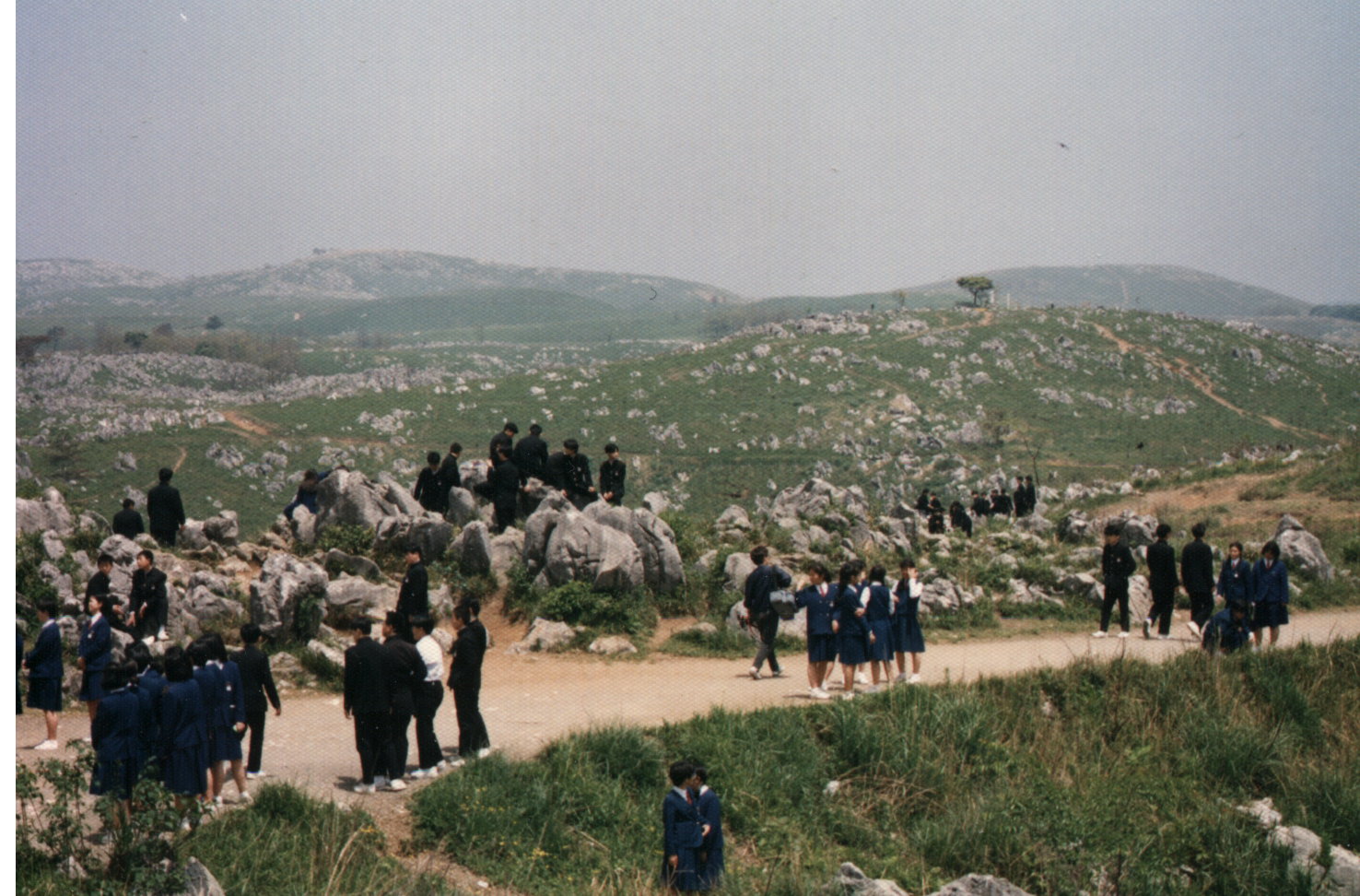
- Akiyoshidai Quasi-National Park, which includes the Akiyoshidai (秋吉台 Akiyoshi plateau) and Japan’s longest cave, the Akiyoshido (秋芳洞), the latter of which is designated a Special Natural Monument. Akiyoshidai is served by a natural history museum, visitor center, rest house, youth hostel and park headquarters building, and is traversed by a scenic roadway and several walking trails. Events include a fireworks festival in July, a “Karst Walk” in November, and an annual burning off of dry grasses in February called “Yamayaki”.
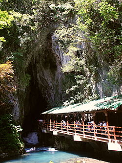 Akiyoshi-do cave.
- Akiyoshido, Akiyoshido (秋芳洞). Towards the southern end of Akiyoshidai is the Akiyoshido cave, named by Emperor Hirohito on May 30, 1926 when he was still crown prince. This spacious cave is up to 100 meters wide and has 8.79 kilometers of passages, making it the longest in Japan and one of the longest in Asia. At the present time an approximately one-kilometer-long section of the cave is open to the public as a sightseeing course, with a walkway and bridge system, entering at the cave's lowest point and exiting via an artificial elevator. This portion of the cave is also well decorated with a variety of large and colorful speleothems.
Geology
The plateau consists of uplifted reef limestones of Paleozoic age, which were thickened by overfolding during the Akiyoshidai orogenic movement. Subsequent erosion has created an undulating karst landscape dimpled with many dolines and countless limestone pinnacles up to two meters in height. Beneath the surface lie hundreds of caves, a few of them quite significant geologically.
View of Karst landscape.Numerous fossils of Pleistocene age have been found in these caves, including those of the Japanese rhinoceros, Stegodont elephant, Naumann elephant, Young tiger, and numerous other animals from the last interglacial period.
The area around Akiyoshidai was once heavily forested about 500,000 years ago. In the Jōmon period, the area served as a hunting ground and the bottoms of sinkholes as vegetable fields. Numerous Paleolithic artifacts have been recovered. As farming began in Japan, the local people eventually replaced the forested landscape with Japanese pampas grass for feeding their animals and thatching houses. Repeated cycles of burning the grass have kept trees from growing back since.
 Stalactite called "Gold Column".
Transportation
Trains
- West Japan Railway Company(JR Nishi Nihon) stations
- Mine Line
- Atsu Station
- Shirōgahara Station
- Minami-Ōmine Station
- Mine Station
- Shigeyasu Station
- Ofuku Station
- Mine Line
Roads
Expressway
- Mine interchange
- Mine-nishi interchange
Prefectural symbols
- Tree: Red pine tree (Pinus densiflora)
- Flower: Bitter summer mandarin blossom (Citrus natsudaidai)
- Bird: Hooded crane (Grus monacha)
- Fish: Tetraodontidae (Takifugu rubripes)
- Beast: Sika Deer (Cervus nippon nippon)
Famous people from Yamaguchi
- Kido Takayoshi, one of the two main architects of the Meiji Restoration
- Former Prime Minister Shinzo Abe represented first Yamaguchi's 1st then 4th district in the House of Representatives; his father represented Yamaguchi as well.
- Atsushi Tamura of the comic duo London Boots Ichi-go Ni-go is from Shimonoseki in Yamaguchi.
- Teruzane Utada music producer, manager and father of Utada Hikaru is from somewhere in Yamaguchi Prefecture, as mentioned on the latter's blog.
- Sayumi Michishige, a Japanese idol who is one of the 6th generation members of Japanese idol group Morning Musume was also born in Yamaguchi.
- Raizo Tanaka, a Japanese rear admiral during World War II. Tanaka was the commander of the Midway invasion force and later made famous for his efforts to keep Japanese forces on Guadalcanal in supply with the "Tokyo Express."
- Prime Minister Naoto Kan was born in Ube in 1946.[3]
- Karyu, guitarist of the band D'espairsRay is from Yamaguchi. The band had a "homecoming" live there in 2007 and 2009.
- Harukichi Yamaguchi, founder of the Yamaguchi-gumi,born near Kobe but his entire family hailed from Yamaguchi.
- Shintaro Abe, former Minister of Foreign Affairs and General Secretary of the LDP.
- Itō Hirobumi, a samurai of Chōshū domain, Japanese statesman, four time Prime Minister of Japan (the 1st, 5th, 7th and 10th), genrō and Resident-General of Korea.
- Yasunori Mitsuda, Composers
External links
 Media related to Mine, Yamaguchi at Wikimedia Commons
References
- ^ http://www.pref.yamaguchi.lg.jp/foreign/english/history.html The History of Yamaguchi Prefecture
- ^ http://www.jpca.or.jp/62_f.htm
- ^ Kantei bio notes
 Yamaguchi Prefecture
Cities 
Abu District Kuga District Kumage District Ōshima District Categories:- Cities in Yamaguchi Prefecture
- Yamaguchi geography stubs


Wikimedia Foundation. 2010.