- Mihara, Hiroshima
-
Mihara
三原市— City — 
FlagLocation of Mihara in Hiroshima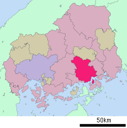

 Mihara
Coordinates: 34°24′N 133°5′E / 34.4°N 133.083°ECoordinates: 34°24′N 133°5′E / 34.4°N 133.083°E Country Japan Region Chūgoku (San'yō) Prefecture Hiroshima Government - Mayor Yasuyuki Gotō Area - Total 471.03 km2 (181.9 sq mi) Population (March 2008) - Total 103,162 - Density 219/km2 (567.2/sq mi) Time zone Japan Standard Time (UTC+9) City symbols - Tree Camphor laurel - Flower Ume and Satsuki azalea Phone number 0848-64-2111 Address 3-5-1, Minatomachi, Mihara-shi, Hiroshima-ken
723-8601Website Mihara City Mihara (三原市 Mihara-shi) is a city located in Hiroshima, Japan.
The city was founded on November 15, 1936.
On March 22, 2005 the town of Daiwa, from Kamo District, the town of Kui, from Mitsugi District, and the town of Hongō, from Toyota District, merged with the old city of Mihara to form the new city of Mihara.
As of March 1, 2008, the city has an estimated population of 103,162 and the density of 219 persons per km². The total area is 471.03 km².
Contents
History
- Mihara Castle was established as a waterfront castle (Umi-jiro) by Kobayakawa Takakage in 1582.
- The castle has been connected to the Seto Inland Sea to operate the Mōri clan water forces on the sea.
- For the Battle of Sekigahara, Fukushima Masanori entered Hiroshima Castle in 1600, and then Mihara Castle has been under controlled as the branch castle of Hiroshima castle.
- The domain was divided into Fukuyama Domain and Hiroshima Domain in 1619, and Tadayoshi Asano entered Mihara castle.
- Mihara was incorporated into a part of Hiroshima Prefecture for the Abolition of the han system in 1871.
- Mihara city was founded on November 15, 1936.
- On March 22, 2005 the town of Daiwa, from Kamo District, the town of Kui, from Mitsugi District, and the town of Hongō, from Toyota District, merged with the old city of Mihara to form the new city of Mihara.
Economy
Fisheries
- Shunami Port
- Nouji Port
Industries
- Mitsubishi Heavy Industries's Itozaki, Kohama and Wada Plants
- Teijin Mihara Plant
- Sharp Mihara Plant
- Dai Nippon Printing Mihara Plant
- Koyo Dockyard
- Mexichem Flúor Mihara Plant
Sister cities
 - Yugawara, Kanagawa, Japan
Educations
- Prefectural University of Hiroshima Mihara
- Mihara Nursing School
Transportation
Airports
Trains
- JR West lines
- Sanyō Shinkansen; Mihara Station
- Sanyō Main Line; Itozaki Station, Mihara and Hongo Station
- Kure Line; Mihara, Sunami Station and Akisaizaki Station
Buses
- Geiyo Bus
- Chugoku Bus
- Tomotetsu Bus
- Onomichi Bus
Highways
National Routes
- Japan National Route 2, 185, 486 and 432
Ports
- Mihara Port
- Onomichi-itozaki Port
- Sagi Port
- Sunami Port
Tourism
Castles
- Mihara Castle
- Nitakayama Castle
Temples
- Daizen-ji
- Buttsū-ji - Chūgoku 33 Kannon Pilgrimage #12
Shrines
- Mitsugi-hachimangu
Festivals
- Mihara Yassa Matsuri
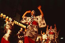 Yassa Festival in August
People
Historical
Famous
- Ayako Miyake (三宅綾子), dancer
- Choji Murata (村田兆治), baseball player
- Ko Hiura (火浦功), novelist
- Yoshihisa Ishida (石田義久), shot putter
- Leyona, singer and songwriter
- Masatoshi Kawahara, manga artist
- Ryuji Imada, professional golfer
- Satoshi Urushihara, manga artist
- Hisatoshi Shintaku, long-distance runner
- Keiko Ikeda, Bronze medalist of 1964 Summer Olympics in Tokyo
External links
 Media related to Mihara, Hiroshima at Wikimedia Commons
- Mihara official website in Japanese
 Hiroshima Prefecture
Hiroshima (capital city) Other cities Aki District Jinseki District Sera District Toyota District Yamagata District 
This Hiroshima Prefecture location article is a stub. You can help Wikipedia by expanding it. - Mihara Castle was established as a waterfront castle (Umi-jiro) by Kobayakawa Takakage in 1582.

