- Tindouf
-
Tindouf
بلدية تندوف
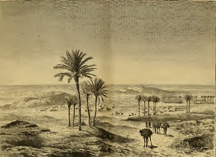
Tinduf— Municipality — Commune of Tindouf Tindouf in 1880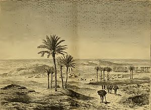 Location of Tindouf within Algeria
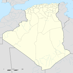
 Tindouf
Coordinates: 27°40′31″N 8°07′43″W / 27.67528°N 8.12861°WCoordinates: 27°40′31″N 8°07′43″W / 27.67528°N 8.12861°W Country  Algeria
Province Tindouf (seat) District Tindouf (seat) Government – PMA Seats 11 Area – Total 70,009 km2 (27,030.6 sq mi) Population (1998) – Total 32,004 – Density 0.5/km2 (1.2/sq mi) Time zone CET (UTC+01) Postal code 37000 ONS code 3701 Tindouf (Berber: Tinduf, Arabic: تيندوف) is the main town in Tindouf Province, Algeria, close to the Mauritanian and Moroccan borders. The region is considered of strategic significance, and it houses Algerian military bases. Since 1975, it also contains several Sahrawi refugee camps operated by the Polisario Front a guerrilla group seeking the independence of Western Sahara from Morocco. The city is served by the Tindouf Airport, northwest of the town, with regular flights to Algiers as well as to other domestic destinations. Within the municipal territory of Tindouf, there is Gara Djebilet, a settlement near the border with Mauritania with a iron mine and a defunct airport. It is approximately 70 kilometers northwest of Aet Legra.
Contents
History
The town of Tindouf was built near an isolated Saharan oasis in 1852 by members of the Tajakant tribe, but sacked and destroyed by Reguibat, a Sahrawi tribe in 1895, and the Tajkant tribe were kicked out of the region. It remained deserted until French troops arrived in the area in 1934. Since Algerian independence in 1962, the town has been purposely built up, partly because of its importance as a last outpost before the Moroccan and Mauritanian borders.
In 1963, the area was the scene of fighting between Algerian and Moroccan forces laying claim to western Algeria, in the Sand War. The region has since been heavily militarized, increasing its relevance. Since the mid-70s, the Tindouf region served as base for the Polisario Front, a Sahrawi nationalist organization fighting for Western Sahara's independence. The Polisario Front is headquartered in self-adminstered refugee camps south of the city, which filled up as Moroccan and Mauritanian forces conquered Western Sahara in 1975. During the war years of 1975-1990, Polisario forces struck in Western Sahara, Mauritania (until 1979) and southern Morocco (incuding the region of Tata), using the Tindouf region as their rear base area, with Algerian protection and support. Since 1990 the area has been quiet, although the refugee community remains in Algeria, pending a UN-sponsored peace process and a referendum on independence. (See Minurso.)
Demographics
Tindouf has a population of 47,965 (2010 estimates).[1]. Though this figure is of questionable authenticity, given the fact that the exact number is a sensitive issue due to the Western Sahara refugees.
Year Population 1977 (Census) 6,044 1987 (Census) 13,084 1998 (Census) 32,004 2010 (Estimate) 47,965 - 59,898 Climate
Climate data for Tindouf, Algeria Month Jan Feb Mar Apr May Jun Jul Aug Sep Oct Nov Dec Year Record high °F (°C) 85
(29)90
(32)102
(39)105
(41)109
(43)124
(51)135
(57)121
(49)116
(47)108
(42)97
(36)83
(28)135
(57)Average high °F (°C) 71
(22)78
(26)83
(28)90
(32)94
(34)101
(38)113
(45)111
(44)101
(38)88
(31)79
(26)71
(22)90 Average low °F (°C) 41
(5)44
(7)53
(12)55
(13)60
(16)63
(17)77
(25)78
(26)72
(22)58
(14)52
(11)42
(6)58 Record low °F (°C) 25
(−4)30
(−1)37
(3)45
(7)46
(8)45
(7)61
(16)55
(13)56
(13)47
(8)35
(2)33
(1)25
(−4)Precipitation inches (mm) 0.1
(3)0.1
(3)0.2
(5)0.1
(3)0.1
(3)0.1
(3)0.1
(3)0.4
(10)0.3
(8)0.1
(3)0.1
(3)0.1
(3)1.8
(46)Sunshine hours 257 263 301 342 353 357 338 319 282 288 249 254 3,603 Source: http://www.weatherbase.com/ [2] References
 Tindouf Province
Tindouf District Tindouf · Oum El Assel 
Provincial seats of Algeria Adrar • Aïn Defla • Aïn Témouchent • Algiers • Annaba • Batna • Béchar • Béjaïa • Biskra • Blida • Bordj Bou Arréridj • Bouïra • Boumerdès • Chlef • Constantine • Djelfa • El Bayadh • El Oued • El Taref • Ghardaïa • Guelma • Illizi • Jijel • Khenchela • Laghouat • Mascara • Médéa • Mila • Mostaganem • M'Sila • Naâma • Oran • Ouargla • Oum el-Bouaghi • Relizane • Saida • Sétif • Sidi Bel Abbès • Skikda • Souk Ahras • Tamanrasset • Tébessa • Tiaret • Tindouf • Tipaza • Tissemsilt • Tizi Ouzou • Tlemcen Categories:
- Tindouf Province
- Province seats of Algeria
- Populated places in Tindouf Province
- Communes of Algeria
- Algeria geography stubs


Wikimedia Foundation. 2010.