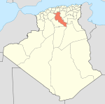
- Djelfa
-
Djelfa — City — Location in Algeria Coordinates: 34°40′N 3°15′E / 34.667°N 3.25°ECoordinates: 34°40′N 3°15′E / 34.667°N 3.25°E Country  Algeria
Province Djelfa Province District Djelfa District Population (1998) - Total 154,265 Time zone CET (UTC+1) Djelfa (Arabic: الجلفة) is the capital city of Djelfa province, Algeria. It has a population of 154,265 (1998 census). The city lies at the junction of the N1 and the N46.
A pleasant medium-size city, north-central Algeria, in the Ouled Nail Mountains at an elevation of 3,734 feet (1,138 m). It is situated between the towns of Bou Saâda and Laghouat. Djelfa town is at a point of transition between the dry, steppelike High Plateaus of the north, with their chotts (intermittent salt lakes), and the Sahara (south). The town was founded in 1852 as a French military post on a geometric plan. It serves as an important livestock market centre for the seminomadic Ouled Nail confederation. Djelfa is on the 12,000 mile Africa Trail.
 Neolithic art in Djelfa
The surrounding region for centuries has been the meeting place of the Ouled Nail, who live in black-and-red striped tents and claim descent from the Prophet Muhammad.
The area is notable for its abundance of Neolithic rock carvings dating from 7000 to 5000 BC. North of Djelfa town there is an imposing physical feature known as Salt Rock (Rocher de Sel) that resulted from the erosion of rock salts and marls by rain, and to the west of the town Megalithic funerary structures are found.
- See separate article, Rock art of the Djelfa region.
During Petain's period, a concentration camp was placed in Djelfa.[1]
External links
- (Arabic) Djelfa Forums
- (French) Djelfa - The capital of the Algerian Highlands
- (English) OHA2004's Blog
References
Provincial seats of Algeria Adrar • Aïn Defla • Aïn Témouchent • Algiers • Annaba • Batna • Béchar • Béjaïa • Biskra • Blida • Bordj Bou Arréridj • Bouïra • Boumerdès • Chlef • Constantine • Djelfa • El Bayadh • El Oued • El Taref • Ghardaïa • Guelma • Illizi • Jijel • Khenchela • Laghouat • Mascara • Médéa • Mila • Mostaganem • M'Sila • Naâma • Oran • Ouargla • Oum el-Bouaghi • Relizane • Saida • Sétif • Sidi Bel Abbès • Skikda • Souk Ahras • Tamanrasset • Tébessa • Tiaret • Tindouf • Tipaza • Tissemsilt • Tizi Ouzou • TlemcenCapital: Djelfa Districts Aïn El Ibil · Aïn Oussera · Birine · Charef · Dar Chioukh · Djelfa · El Idrissia · Faidh El Botma · Had Sahary · Hassi Bahbah · Messaâd · Sidi Ladjel
Communes Aïn Chouhada · Aïn El Ibel · Aïn Feka · Aïn Maabed · Aïn Oussera · Amourah · Benhar · Beni Yagoub · Birine · Bouira Lahdab · Charef · Dar Chioukh · Deldoul · Djelfa · Douis · El Guedid · El Idrissia · El Khemis · Faidh El Botma · Guernini · Guettara · Had-Sahary · Hassi Bahbah · Hassi El Euch · Hassi Fedoul · Messad · Mouilha · Mouadjebara · Oum Laadham · Sed Rahal · Selmana · Sidi Baizid · Sidi Ladjel · Tadmit · Zaafrane · ZaccarCategories:- Province seats of Algeria
- Populated places established in 1852
- Populated places in Djelfa Province
- Communes of Algeria
- Algeria geography stubs
Wikimedia Foundation. 2010.


