- Damnonii
-
The Damnonii (also referred to as Damnii) were a people of the late 2nd century who lived in what is now southern Scotland. They are mentioned briefly in Ptolemy's Geography, where he uses both of the terms "Damnonii" and "Damnii" to describe them, and there is no other historical record of them. Their cultural and linguistic affinity is presumed to be Brythonic. However, there is no unbroken historical record, and a partly Pictish origin is not precluded.
The Romans under Agricola had campaigned in the area in 81, and it was Roman-occupied (at least nominally) between the time that Hadrian's Wall was built (c. 122), through the building of the Antonine Wall (c. 138), until the pullback to Hadrian's Wall in 164. Ptolemy's Geography was written within this timeframe, so his account is contemporary.
Contents
The historical record
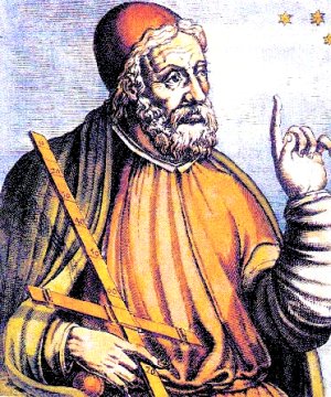
 A medieval artist's rendition of Claudius Ptolemaeus.
The sole record of the Damnonii and their towns is their mention by Ptolemy (c. 80 – c. 168). They are found in no other source.
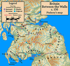
Ptolemy says that the towns of the Damnonii were Vanduara, Colania, Coria, Alauna, Lindum, and Victoria. However, there were no towns as such in the area at that time, so he was likely referring to Roman military camps and native strong points such as duns. Efforts have been made to determine the locations of the towns, but there is not enough information available to reach any degree of certainty, and the locations suggested are little more than guesswork.
Reflecting the lack of evidence, there is little agreement on assigning modern locations to the towns. Among the assignments made by those whose work is considered to be authoritative (to varying degrees) are those of William Baxter (1719, Glossarium Antiquitatum Britannicum)[1], William Camden (1607, Britannia),[2] John Horsley (1732, Britannia Romana),[3] William Forbes Skene (1880, Celtic Scotland, a History of Ancient Alban)[4], George Chalmers (c. 1820, Caledonia),[5] and William Roy (1793, Military Antiquities of the Romans in Britain).[6] Other historians either quote one of these as the authority for assigning locations to Ptolemy's towns, or simply assert a location in passing. A few offer lists of the assertions of the above authorities.[7]
Alauna is suggested to be the Camelon that is near and to the west of Falkirk, or at Stirling, or Kier (about 4 miles (6.4 km) NNW of Stirling, on the Allan Water), or the island of Inchkeith. Colania is suggested to be Lanark or Carstairs (about 5 miles (8.0 km) NE of Lanark), or some other place on the east side of Clydesdale. Coria is suggested to be Lynekirk (about 4 miles (6.4 km) WNW of Peebles, or some other place on the east side of Clydesdale. Lindum is suggested to be Kirkintilloch (about 16 miles (26 km) NE of Glasgow), or Linlithgow, or near Ardoch (the one about 10 miles (16 km) NNW of Stirling). Victoria is suggested to be Dalginross (about 5 miles (8.0 km) W of Crieff, or Abernethy (about 5 miles (8.0 km) SE of Perth). Vanduara is suggested to be Paisley or Renfrew (both about 6 miles (9.7 km) to the west of Glasgow), or some 20 miles south of Glasgow at Loudoun Hill.
Fictional evidence
De Situ Britanniae held sway as virtually the only authoritative record of northern Roman Britain from 1757 until it was definitively debunked as a forgery in 1845, and was still a cited source of history until the end of the 19th century. Chalmers and Roy in particular were believers in the authenticity at the time they wrote, and the Damnonii are mentioned (as the Damnii), accompanied by an explanatory commentary.[8] De Situ Britanniae generally followed Ptolemy's map but made novel assertions regarding Damnonii towns.
See also
Notes
- ^ Baxter, William (1719), Baxter, John, ed., Glossarium Antiquitatum Britannicum (2nd ed.), London: T. Woodward, C. Davis, J. Hazard, W. Bickerton, & R. Chandler, 1733, http://books.google.com/?id=3go2AAAAMAAJ
- ^ Camden, William (1607), "Description of Scotland", in Sutton, Dana F., Britannia, The Philological Museum, 2004, http://www.philological.bham.ac.uk/cambrit/
- ^ Horsley, John (1732), Britannia Romana, London: John Osborne and Thomas Longman
- ^ Skene, William Forbes (1876), Celtic Scotland: A History of Ancient Alban, I, Edinburgh: Edmonston & Douglas, http://books.google.com/?id=ErQHAAAAQAAJ
- ^ Chalmers, George (1890), Caledonia, VI (New ed.), Paisley: Alexander Gardner, http://books.google.com/?id=WXRfzo_IHwwC
- ^ Roy, William (1793), The Military Antiquities of the Romans in Britain, London: The Society of Antiquities of London, http://www.nls.uk/maps/roy/antiquities/
- ^ Henry, Robert (1805), The History of Great Britain on a New Plan, II (3rd ed.), London: A. Strahan, T. Cadell Jr. and W. Davies, in the Strand (published 1800), pp. 403–404, http://books.google.com/?id=OY4rAAAAMAAJ
- ^ Bertram, Charles (1757), The Description of Britain, Translated from Richard of Cirencester, London: J. White and Co (published 1809), pp. 55–59, 72, 75, http://books.google.com?id=OwJIAAAAMAAJ
Iron Age tribes in Britain Atrebates • Belgae • Brigantes • Caereni • Caledonii • Cantiaci • Carnonacae • Carvetii • Catuvellauni • Coritani • Corionotatae • Cornovii (Central) • Cornovii (Northern) • Creones • Damnonii • Decantae • Deceangi • Demetae • Dobunni • Dumnonii • Durotriges • Epidii • Gabrantovices • Iceni • Lopocares • Lugi • Novantae • Ordovices • Parisii • Regnenses • Selgovae • Setantii • Silures • Smertae • Taexali • Textoverdi • Trinovantes • Vacomagi • Venicones • VotadiniCategories:- Celtic culture
- History of Scotland
- Tribes of ancient Britain
- Roman military occupation in southern Scotland
- Iron Age Scotland

Wikimedia Foundation. 2010.