- Corieltauvi
-
Corieltauvi 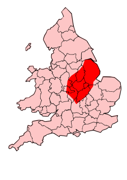 Territory of the Corieltauvi
Geography Capital Ratae Corieltauvorum (Leicester) Location Lincolnshire
Leicestershire
Nottinghamshire
Derbyshire
RutlandRulers Volisios
Dumnocoveros, Dumnovellaunus, CartiveliosThe Corieltauvi (formerly thought to be called the Coritani, and sometimes referred to as the Corieltavi) were a tribe of people living in Britain prior to the Roman conquest, and thereafter a civitas of Roman Britain. Their territory was in what is now the English East Midlands, in the counties of Lincolnshire, Leicestershire, Nottinghamshire, Derbyshire, Rutland and Northamptonshire. They were bordered by the Brigantes to the North, the Cornovii to the West, the Dobunni and Catuvellauni to the South, and the Iceni to the East. Their capital was called Ratae Corieltauvorum, known today as Leicester.
Contents
Late Iron Age
The Corieltauvi were a largely agricultural people who had few strongly defended sites or signs of centralised government. They appear to have been a federation of smaller, self-governing tribal groups. From the beginning of the 1st century, they began to produce inscribed coins: almost all featured two names, and one series had three, suggesting they had multiple rulers. The names on the earliest coins are so abbreviated as to be unidentifiable. Later coins feature the name of Volisios, apparently the paramount king of the region, together with names of three presumed sub-kings, Dumnocoveros, Dumnovellaunus and Cartivelios, in three series minted ca. 45 AD. The Corieltauvi had an important mint, and possibly a tribal centre, at Sleaford.
The discovery in 2000 of the Hallaton Treasure more than doubled the total number of Corieltauvian coins previously recorded.
Roman times
They seem to have offered little or no resistance to Roman rule, perhaps welcoming them as protection against aggressive neighbours such as the Brigantes.[citation needed] Ratae was captured c. AD 44, and the IX Hispana legion was garrisoned there. The Fosse Way, a Roman road and the effective early boundary of the Roman province, passed through their territory.
Name
Their name appears as Coritani and Coritavi in Ptolemy's 2nd century Geography. However, the Ravenna Cosmography gives the name of their capital, in apparently corrupt form, as Rate Corion Eltavori, and an inscribed tile found in Churchover calls the administrative district Civitas Corieltauvorum, indicating that the true form should be Corieltauvi.[1][2] Manley Pope, author of an early English translation of the Welsh chronicle Brut y Brenhinedd, associated the Coritani of the Roman writers with the magical race called the Coraniaid in the medieval Welsh tale Lludd and Llevelys.[3]
The name has been adopted by the athletics club, Leicester Coritanian A.C..
References
- ^ Tomlin, R S O (1983). "Roman Leicester, a Corrigendum: For Coritani should we read Corieltauvi?". Transactions of the Leicester Archaeological and Historical Society 48. http://www.le.ac.uk/lahs/downloads/CoritaniPagesfromvolumeLVIII-2.pdf.
- ^ Tomlin, R S O (1983). "Non Coritani sed Corieltauvi". The Antiquaries’ Journal 63.
- ^ Pope, Manley (1862). "A History of the Ancient Kings of Britain". London: Simpkin, Marshall, and Co. Retrieved April 21, 2009.
Iron Age tribes in Britain Atrebates • Belgae • Brigantes • Caereni • Caledonii • Cantiaci • Carnonacae • Carvetii • Catuvellauni • Coritani • Corionotatae • Cornovii (Central) • Cornovii (Northern) • Creones • Damnonii • Decantae • Deceangi • Demetae • Dobunni • Dumnonii • Durotriges • Epidii • Gabrantovices • Iceni • Lopocares • Lugi • Novantae • Ordovices • Parisii • Regnenses • Selgovae • Setantii • Silures • Smertae • Taexali • Textoverdi • Trinovantes • Vacomagi • Venicones • VotadiniPart of: Celtic tribes in Europe Categories:- History of Leicestershire
- Leicestershire
- Tribes of ancient Britain

Wikimedia Foundation. 2010.