- Neepawa, Manitoba
-
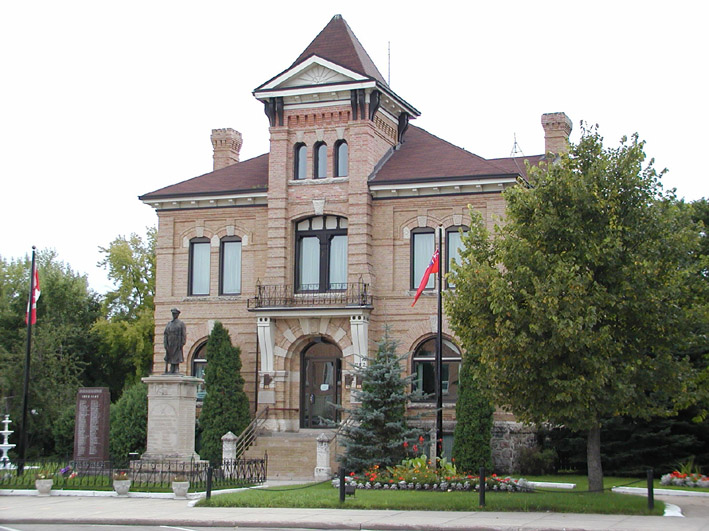
Town of Neepawa Neepawa Courthouse Location of Neepawa in Manitoba
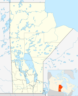
 Town of Neepawa
Coordinates: 50°13′44″N 99°27′56″W / 50.22889°N 99.46556°W Country Canada Province Manitoba Region Westman Incorporated 1883 Government - Mayor Ron Forsman - Town Council Neepawa Town Council - MLA Ste. Rose Stu Briese (PC) - MP Dauphin-Swan River-Marquette Robert Sopuck (PC) Area - Total 17.57 km2 (6.8 sq mi) Elevation 358.1 m (1,175 ft) Population (2006) - Total 3,298 - Density 187.7/km2 (486.1/sq mi) Time zone Central (CST) (UTC-6) - Summer (DST) Central (CDT) (UTC-5) Postal code R0J 1H0 Area code(s) 204 Website Town of Neepawa Neepawa is a town in Manitoba, Canada located on the Yellowhead Highway at the intersection with Highway 5. As of 2006[update] its population was 3,298.[1] Neepawa was incorporated as a town in 1883. It is located in the Rural Municipality of Langford and bordered to the north by the Rural Municipality of Rosedale. Neepawa is the self-proclaimed Lily capital of the world in part because of its Lily Festival.[2] The town has also been named "Manitoba's Most Beautiful Town", more than any other community in the province.[3]
Contents
History
In the many years before European settlement, the lands around Neepawa were primarily used by the Cree and the Assiniboine. Native peoples in the area followed a regular cycle by following the Plains Bison to take shelter in the areas north of Neepawa in the winter, and then heading south again across the plains and beyond Neepawa in the summer.[4] The town name of Neepawa comes from the Cree word for "Land of Plenty", the name was first used around 1873.[5] Prior to settlement, the only Europeans in the area were primarily fur traders, many people made their way through the area on the North Fort Ellice Trail which went from the Red River to Edmonton.[4] It was on this trail that a group of settlers from Listowel, Ontario eventually decided to settle in 1877, where the Stony and Boggy creeks meet.[4]
The Province of Manitoba was established in 1870, the Neepawa area was in what was then known as "The Northwest Territories", just to the west of the postage stamp province. During the next 30 years, many settlers came to live in the area. The first settlers were from the British Isles. Eastern European settlers also came from countries such as Poland and Hungary and built the Hun Valley Settlement near Neepawa.[5] Neepawa only joined Manitoba when the western edge of the then "postage stamp province" was expanded to its present western borders in 1881.[5]
John A. Davidson and Jonathon J. Hamilton arrive in the town in 1880, they were the first real business men of the town buying land and surveying them into lots.[4] In 1881 John Hamilton and John Davidson built a store and a grist mill near the junction of Boggy and Stoney Creeks. Like many western Manitoba towns at the time, Neepawa eagerly await the arrival of the railway in the 1880s. Sometime after the railway reached Gladstone, Manitoba in 1882, Davidson and Hamilton offered the Manitoba and Northwestern Railway (which was leased to CPR) a land grant and a financial bonus of $16,000 to construct their line within the town limits and the railway agreed to build their station within Neepawa.[4]
Soon a village grew and on the 23 of September, 1883 the town of Neepawa was incorporated.[6] Dr. David Harrison who owned a private bank in Neepawa was elected Premier of Manitoba in 1887.[7] Neepawa's first hospital was completed in 1904 and had the capacity for 20 patients. The hospital included a nursing school. Neepawa's first school opened in 1881. It was a three story building finally completed in 1898 and used until 1928. The Neepawa Salt Company mined salt here from 1932 until 1970.[8]
Author Margaret Laurence wrote several books through the 1960s and 1970s, depicting the town under the name of Manawaka. On May 12, 2010 Neepawa was the host of Manitoba's 140th birthday party. The town was chosen as the site of the festivities as a result of winning a contest within the province.[9]
Geography
Neepawa lies on the Manitoba Escarpment, the rolling hills around Neepawa are typical of the escarpment. Neepawa lies within the Canadian Prairies, the region around Neepawa is defined as Aspen parkland. Although Neepawa is part of the prairies the area to the north is heavily forested Parkland. Riding Mountain National Park and Duck Mountain Provincial Park lie to the north, are part of this parkland, and are also an extension of the escarpment. The boreal forest which extends all the way across Canada, is also found to the north of Neepawa. Spruce Woods Provincial Park is located about 60 km south of the town.
Neepawa lies at the source of the Whitemud River, it is also about 40 km east of the Little Saskatchewan River, a tributary of the Assiniboine River which is 60 km south of the town. The town is also about 60 km west of Lake Manitoba, one of the largest lakes in Manitoba.
Climate
Climate data for Neepawa Water Month Jan Feb Mar Apr May Jun Jul Aug Sep Oct Nov Dec Year Record high °C (°F) 7
(45)10
(50)17
(63)34
(93)36
(97)37
(99)36
(97)37.5
(99.5)35.5
(95.9)30
(86)20.6
(69.1)8.3
(46.9)37.5
(100)Average high °C (°F) −11.9
(10.6)−8
(18)−0.9
(30.4)9.4
(48.9)17.9
(64.2)22.4
(72.3)24.8
(76.6)24.2
(75.6)17.7
(63.9)10.4
(50.7)−1
(30)−9.3
(15.3)8 Average low °C (°F) −22.2
(−8.0)−18.5
(−1.3)−11.2
(11.8)−2.6
(27.3)5.1
(41.2)10.6
(51.1)13
(55)11.5
(52.7)6.1
(43.0)−0.1
(31.8)−9.4
(15.1)−18.9
(−2.0)−3.1 Record low °C (°F) −41
(−42)−42.5
(−44.5)−36
(−33)−27.2
(−17.0)−12
(10)-0
(32)3
(37)0
(32)−6
(21)−21
(−6)−34
(−29)−42
(−44)−42.5
(−45)Precipitation mm (inches) 20.1
(0.791)14.6
(0.575)24.4
(0.961)35
(1.38)58.4
(2.299)79.5
(3.13)82
(3.23)70.4
(2.772)57.9
(2.28)31.3
(1.232)20.8
(0.819)22
(0.87)516.3
(20.327)Source: Environment Canada[10] Economy
The economy of Neepawa and the region is strongly dependent on agriculture. The rolling fields in the area support many types of crops and livestock operations. Neepawa serves as a major agricultural service centre for many of the producers in the region.
More prominently, growers in Neepawa produce some of the finest and most diverse lilies in the world. As of 2009 over 2,000 kinds of Lily were grown locally.[2] These flowers are shipped directly from Neepawa to many of the major international floral markets.[citation needed] Neepawa proclaims itself the "Lily capital of the world" because of this.[2] Neepawa also attracts a number of tourists throughout the year in part because of the lilies. An estimated 12,000 people visit the Lily Festival and Neepawa each July.[2]
As well as being an agricultural centre, Neepawa's businesses serve as a shopping and retail centre for much of the area's residents.
Education
Hazel M. Kellington Elementary School (named after long time teacher) has about 350 students and the Neepawa Area Collegiate Institute has about 500 students. Neepawa Nursery School teaches 3 and 4 year old children. Neepawa is part of the Beautiful Plains School Division
Assiniboine Community College has a campus in Neepawa and offers various post-secondary courses.
Transportation
The Town of Neepawa is located along the Yellowhead Highway 16 and Highway 5, the Parks Route. The community is located 45 minutes northeast of Brandon, the region's largest centre, and 2 hours northwest of Winnipeg, the provincial capital. Neepawa is also located 1 hour from Riding Mountain National Park. The Town of Neepawa features a 3,500 foot runway that is able to service air ambulance and small jets. The Canadian Pacific Railway services Neepawa for freight transportation. Neepawa is serviced by both Grey Goose and Greyhound Bus lines. Daily Courier services are provided by three major companies. Trucking services are provide by Gladstone Transfer and Gardewine, which maintains a depot in Neepawa.
Attractions
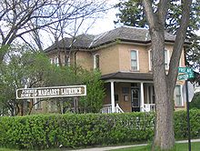 Margaret Laurence Home
The Margaret Laurence Home is a designated Provincial Heritage Site and a Level 2 Museum. This is the house where Margaret Laurence grew up in Neepawa as a youth. In addition the Riverside Cemetery in Neepawa is the resting place of Margaret Laurence. The cemetery's Davidson Memorial was the signature of Laurence's book The Stone Angel.[11] This cemetery is also the furthest west that any Titanic passenger was buried.[11] The Beautiful Plains Museum is a Heritage Railway Station that was the home of the museum since 1981. The original railway station itself was built in 1901.[12]
The Lily Festival in Neepawa first began in 1996 and today features the over 2,000 different kinds of Lily that are grown in Neepawa.[2] Neepawa sees around 12,000 visitors in the town during the Lily Festival each July.[2]
Government
Neepawa is governed by a town council consisting of a mayor and six councilors. The town council is elected to a four-year term. The current mayor of Neepawa is Ron Forsman. Current councilors include: Murray Parrot , Monty Simon, Liza Pottinger, Bill Stilwell, Robyn Copeland and Dean Dietrich.
Sports
Junior and senior sports teams in Neepawa include:
- Neepawa Natives (Manitoba Junior Hockey League)
- Neepawa Farmers (Manitoba Senior Baseball League)
- Neepawa Cubs (Manitoba Junior B Baseball League)
Media
- Newspapers
- Neepawa Banner - weekly (circulation 11,000)[citation needed]
- Neepawa Press - weekly (circulation 8,856)[citation needed]
- Radio
- CJBP-FM 97.1
- Television
- NAC TV channel 30
- Magazine, books
- William Street Publishing <http://www.manitobawild.com/>
Notable natives
- Shane Hnidy, professional ice-hockey player in the NHL
- Margaret Laurence, novelist
- Welford Russell, composer and surgeon
- Remi Bouchard, composer and teacher
- Bill Stilwell, author
References
- ^ "Population and dwelling counts, for Canada and census subdivisions (municipalities), 2006 and 2001 censuses - 100% data". 2006 Canadian Census. http://www12.statcan.ca/census-recensement/2006/dp-pd/hlt/97-550/Index.cfm?TPL=P1C&Page=RETR&LANG=Eng&T=302&SR=151&S=1&O=A&RPP=25&PR=46&CMA=0. Retrieved 2009-03-23.
- ^ a b c d e f "NEEPAWA: Lily Capital of the World; home of literary legend". Winnipeg Free Press. 1 August 2009. http://www.winnipegfreepress.com/travel/lily-capital--of-the-world-home-of--literary-legend-52257412.html. Retrieved 2010-07-21.
- ^ "Sweet home Manitoba". Winnipeg Free Press. 4 January 2010. http://www.winnipegfreepress.com/opinion/editorials/sweet-home-manitoba-80565512.html. Retrieved 2010-07-21.
- ^ a b c d e "Introduction to the History of Neepawa". The Town of Neepawa. http://www.neepawa.ca/museum/neephist.htm. Retrieved 2010-08-04.[dead link]
- ^ a b c "Our History". The Town of Neepawa. http://town.neepawa.mb.ca/profile/detail.asp?ID=8. Retrieved 2010-10-30.[dead link]
- ^ "Town of Neepawa". The Manitoba Historical Society. http://www.mhs.mb.ca/docs/municipalities/neepawa.shtml. Retrieved 2010-07-20.
- ^ "Harrison, David Howard". Canadian Biography Online. http://www.biographi.ca/009004-119.01-e.php?&id_nbr=6769. Retrieved 2010-07-22.
- ^ "Manitoba Mining Through the Centuries". Government of Manitoba. http://www.gov.mb.ca/stem/mrd/min-ed/minfacts/mbhistory/commodities.html. Retrieved 2010-08-04.
- ^ "Neepawa hosts Manitoba birthday bash". Winnipeg Free Press. 12 May 2010. http://www.cbc.ca/canada/manitoba/story/2010/05/12/mb-birthday-bash-neepawa-manitoba.html. Retrieved 2010-07-21.
- ^ Environment Canada—[1]. Retrieved 22 July 2010.
- ^ a b "Riverside Cemetery". The Town of Neepawa. http://town.neepawa.mb.ca/profile/cemetery.asp. Retrieved 2010-07-21.[dead link]
- ^ "Beautiful Plains Museum". The Town of Neepawa. http://town.neepawa.mb.ca/profile/musuem.asp. Retrieved 2010-07-21.[dead link]
External links
- Town of Neepawa
- Manitoba Holiday Festival of the Arts
- Beautiful Plains Museum
- Margaret Laurence Home
- Neepawa Lily Festival
- First Baptist Church Neepawa
- Viscount Cultural Centre
- Whitemud Watershed Conservation District
- Kaleidoscope Concerts Neepawa
- Beautiful Plains Community Foundation
- Map of Neepawa at Statcan

Wasagaming McCreary Lake Manitoba Minnedosa 
Gladstone  Neepawa

Brandon Carberry Austin, MacGregor  Subdivisions of Manitoba
Subdivisions Cities  Category:Manitoba ·
  Portal:Manitoba ·
  WikiProject:Manitoba
Coordinates: 50°13′44″N 99°27′56″W / 50.22889°N 99.46556°W
Categories:- Towns in Manitoba


Wikimedia Foundation. 2010.