- Nollville, West Virginia
-
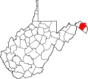
Nollville — Unincorporated community — Location within the state of West Virginia Coordinates: 39°27′45″N 78°1′12″W / 39.4625°N 78.02°WCoordinates: 39°27′45″N 78°1′12″W / 39.4625°N 78.02°W Country United States State West Virginia County Berkeley Time zone Eastern (EST) (UTC-5) – Summer (DST) EDT (UTC-4) ZIP codes FIPS code GNIS feature ID 1555231 Nollville is an unincorporated community on Tuscarora Creek in Berkeley County, West Virginia. It lies west of Martinsburg on the Tuscarora Pike (County Route 15).
Located near Nollville are the Ridge Road Historic District and Tuscarora Creek Historic District, both listed on the National Register of Historic Places in 1980.[1]
References
- ^ "National Register Information System". National Register of Historic Places. National Park Service. 2009-03-13. http://nrhp.focus.nps.gov/natreg/docs/All_Data.html.
Municipalities and communities of Berkeley County, West Virginia City Town CDPs Other localities Allensville | Arden | Baker Heights | Baxter | Bedington | Berkeley | Bessemer | Blairton | Bunker Hill | Darkesville | Douglas Grove | Files Crossroad | Ganotown | Georgetown | Gerrardstown | Glengary | Goose Nest | Greensburg | Grubbs Corner | Hainesville | Johnsontown | Jones Springs | Little Georgetown | Marlowe | Nipetown | Nollville | North Mountain | Pikeside | Ridgeway | Scrabble | Shanghai | Spring Mills | Swan Pond | Tablers Station | Tarico Heights | Tomahawk | Union Corner | Van Clevesville | Vanville | Winebrenners Crossroad | Wynkoop Spring
Categories:- Eastern Panhandle geography stubs
- Populated places in Berkeley County, West Virginia
- Unincorporated communities in West Virginia
Wikimedia Foundation. 2010.


