- New England Interstate Route 10
-
New England Route 10
Route information Length: 237.22 mi (381.77 km)
Connecticut: 54.28[1] mi (87.36 km)
Massachusetts: 60.69[2] mi (97.68 km)
New Hampshire: 122.25 mi [3] (196.74 km)Existed: 1922 – 1930s Major junctions South end: New Haven, CT  Route 2 in Greenfield, MA
North end:  US 302 in Haverhill, NH
Highway system New England road marking system
←  Route 9
Route 11  →
→New England Route 10 was a multi-state north–south state highway in the New England region of the United States, running through Connecticut, Massachusetts, and New Hampshire. "Route 10" still exists as a continuous state highway in each of its original states, running from New Haven, Connecticut to Woodsville, New Hampshire. Its number dates from 1922, when it was a New England Interstate Route, also known as the Central New England Route.
Route 10 is often called the College Highway because it links Yale University, Trinity College, Mount Holyoke College, Smith College, Amherst College, the University of Massachusetts and Dartmouth College. Yale and Dartmouth are in the Ivy League and Smith and Mount Holyoke are in the Seven Sisters group of exclusive women's colleges.
Contents
History
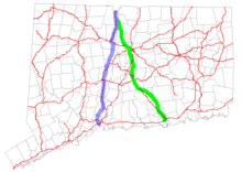 Map of Connecticut showing the original 1920s route in green and the subsequent route in blue
Route 10 originally followed a different route south of Granby, Connecticut, starting in the town of Old Saybrook[4] instead of at its current New Haven terminus. It moved to its current alignment along the Connecticut section of the College Highway in 1932, with the former alignment becoming the original Route 9. The original routing is now Routes 154, 99, and 189.
New England Route 10 also originally ended in Littleton, New Hampshire (at Route 18) but was subsequently truncated to end at its current northern terminus in Woodsville. The rest of the route has had only very minor changes and basically still follows its successor highways in the three states.
Route description
Connecticut
Route 10 in Connecticut began in the city of New Haven. Route 10 continued north through the towns of Hamden, Cheshire, Southington, Plainville, Farmington, Avon, and Simsbury.
Massachusetts
Route 10 in Massachusetts crossed the border from Granby, Connecticut into Southwick, Massachusetts. It ran north through the Pioneer Valley towns of Southwick, Westfield, Southampton, Easthampton, Northampton, Hatfield, Whately, Deerfield, Greenfield, Bernardston, Gill, and Northfield. It crossed the Connecticut River in Northfield before entering New Hampshire.
New Hampshire
Route 10 in New Hampshire began at the Massachusetts state line in Winchester, New Hampshire. The road continued into Keene. From Keene, NH 10 travels north via Newport until Grantham. NH 10 then traveled along the east bank of the Connecticut River from Lebanon up to Woodsville. Signage for Route 10 continued all the way to Littleton.
References
- ^ Connecticut State Numbered Routes and Roads as of December 31, 2004 (PDF)
- ^ Executive Office of Transportation, Office of Transportation Planning - 2005 Road Inventory
- ^ New Hampshire DOT Route Logs
- ^ Oglesby, Scott (2004-09-04). "Connecticut New England Interstates: NE 10". Connecticut Roads. kurumi.com. http://www.kurumi.com/roads/ct/ctne.html#ne10. Retrieved 2006-07-10.
External links
Categories:- New England Interstate Routes


Wikimedia Foundation. 2010.