- Lake Singkarak
-
Singkarak 
Lake Singkarak and the Ombilin river circa 1900 Location West Sumatra, Indonesia Coordinates 0°37′12″S 100°32′24″E / 0.62°S 100.54°ECoordinates: 0°37′12″S 100°32′24″E / 0.62°S 100.54°E Lake type Tectonic Primary inflows Sumani River Primary outflows Ombilin River, Anai River Basin countries Indonesia Surface area 107.8 km² Average depth 149 m [1] Max. depth 268 m Water volume 16.1 km³ Surface elevation 362 m Lake Singkarak (Indonesian: Danau Singkarak) is a lake in West Sumatra, Indonesia. It is located between the cities of Padang Panjang and Solok. It has an area of 107.8 km², being approximately 21 km long and 7 km wide. The natural outlet for excess water is the Ombilin river which flows eastward to the Strait of Malacca. A hydroelectric project however has diverted most of the lake outflow to the Anai river which flows westward into the Indian Ocean near Padang. This Singkarak power station uses this water to generate power for the West Sumatra and Riau provinces. A species of fish called ikan bilih (Mystacoleucus padangensis) is endemic to the lake, and is harvested for human consumption. A railway line, which connects Padang and Sawahlunto-Sijunjung, skirts the length of the lake on the eastern side.
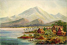 Painting of Lake Singkarak in 1901
See also
- List of lakes of Indonesia
Java Ancol Dreamland · Anyer · Bogor Palace · Borobudur · Dieng Volcanic Complex · G-Land · Istiqlal Mosque · Karimunjawa National Park · Kawah Putih · Kraton Ngayogyakarta Hadiningrat · Kukup Beach · Mount Bromo · Mount Merapi · Ngliyep Beach · Pangandaran · Parangtritis Beach · Patenggang Lake · Pelabuhan Ratu · Prambanan · Puncak · Suramadu Bridge · Tangkuban Perahu · Tanjung Lesung Beach · Thousand Islands · TMII · Trans Studio Bandung · Ujung Kulon National Park · Umang IslandKalimantan Sulawesi Bantimurung - Bulusaraung · Bunaken National Marine Park · Losari Beach · Taka Bone Rate · Tempe Lake · Tondano Lake · Toraja · Trans Studio Makassar · WakatobiLesser Sunda Islands Bedugul · Dreamland Beach · Gili Air · Gili Meno · Gili Trawangan · Jimbaran · Kelimutu Lake · Komodo Island · Kuta (Bali) · Kuta (Lombok) · Lovina Beach · Mount Rinjani · Mount Tambora · Moyo Island · Nusa Dua · Nusa Lembongan · Rinca Island · Sanur · Segara Anak Lake · Seminyak · Senggigi · Tampaksiring · Tanah Lot · Ubud · UluwatuMaluku and Papua References
- (PDF) Impact evaluation study of Asian Development Bank assistance to the power sector. Asian Development Bank. 2003. http://adb.org/Documents/IES/Power_INO/IES_INO_2003_13.pdf. Retrieved 2006-12-24.
- (PDF) Special evaluation study on the social and environmental impacts of selected hydropower projects. Asian Development Bank. 1999. http://www.asiandevbank.org/Documents/PERs/SS-36.pdf. Retrieved 2006-12-24.
- Farida, et al. (2005) (PDF). Rapid Hydrological Appraisal (RHA) of Singkarak Lake in the context of Rewarding Upland Poor for Environmental Services (RUPES). World Agroforestry Centre. http://www.worldagroforestrycentre.org/sea/Networks/RUPES/download/Annual_Reports/Appendices2005/Appendix4-2_RHA_Singkarak_Report.pdf. Retrieved 2006-12-24.
- Rupes Project Team. (2006) (PDF). Linking rewards and governance to effects of land use on environmental services at the scale of the lake. World Agroforestry Centre. http://www.worldagroforestrycentre.org/sea/Networks/RUPES/download/SiteProfiles/RUPES-Singkarak_FINAL.pdf. Retrieved 2006-12-24.
- Kevin Jeanes, et al. (2006) (PDF). Rapid Hydrological Appraisal in the context of environmental service rewards. World Agroforestry Centre. http://www.worldagroforestrycentre.org/sea/Publications/currentpub.asp?publishid=1438. Retrieved 2006-12-24.
- ^ Mean depth calculated as volume / surface area.
Categories:- Lakes of Indonesia
- Sumatra geography stubs


Wikimedia Foundation. 2010.