- MODFLOW
-
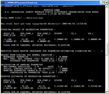 MODFLOW simulation
MODFLOW is the U.S. Geological Survey modular finite-difference flow model, which is a computer code that solves the groundwater flow equation. The program is used by hydrogeologists to simulate the flow of groundwater through aquifers. The code is free software, written primarily in Fortran, and can compile and run on DOS, Windows or Unix-like operating systems.
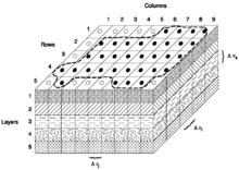 3-dimensional grid
Since its original development in the early 1980s,[1] the USGS have released four major releases, and is now considered to be the de facto standard code for aquifer simulation. Currently, there are at least five actively developed commercial and non-commercial graphical user interfaces for MODFLOW.
Contents
Groundwater flow equation
The governing partial differential equation used in MODFLOW is:
where
- Kxx, Kyy and Kzz are the values of hydraulic conductivity along the x, y, and z coordinate axes (L/T)
- h is the potentiometric head (L)
- W is a volumetric flux per unit volume representing sources and/or sinks of water, where negative values are extractions, and positive values are injections (T−1)
- SS is the specific storage of the porous material (L−1); and
 is time (T)
Finite difference
The finite difference form of the partial differential in a discretized aquifer domain (represented using rows, columns and layers) is:
where
 is the hydraulic head at cell i,j,k at time step m
- CV, CR and CC are the hydraulic conductances, or branch conductances between node i,j,k and a neighboring node
 is the sum of coefficients of head from source and sink terms
 is the sum of constants from source and sink terms, where
  is flow out of the groundwater system (such as pumping) and
  0.0\," border="0"> is flow in (such as injection)
 is the specific storage
 are the dimensions of cell i,j,k, which, when multiplied, represent the volume of the cell; and
 is the time at time step m
This equation is formulated into a system of equations to be solved as:
where
or in matrix form as:
where
- A is a matrix of the coefficients of head for all active nodes in the grid
 is a vector of head values at the end of time step m for all nodes in the grid; and
 is a vector of the constant terms, RHS, for all nodes of the grid.
Limitations
- The water must have a constant density, dynamic viscosity (and consequently temperature) throughout the modelling domain (SEAWAT is a modified version of MODFLOW which is designed for density-dependent groundwater flow and transport)

- The principal components of anisotropy of the hydraulic conductivity used in MODFLOW is displayed on the right. This tensor does not allow non-orthogonal anisotropies, as could be expected from flow in fractures. Horizontal anisotropy for an entire layer can be represented by the coefficient "TRPY" (Data Item 3 Page 153 [2].
Versions
 Cover image from McDonald & Harbaugh (1983)[2], which illustrates a computer surrounded by modules and arrays used by MODFLOW. This was said at the time to resemble a "component stereo system".
"Modular Model"
The USGS throughout the 1970s had developed several hundred models, written in different dialects of FORTRAN. At the time, it was common practice to rewrite a new model to fit the need of a new groundwater scenario. The concept for MODFLOW was originally designed in 1981 to provide a common modular groundwater model, which could be compiled on multiple platforms without major (or any) modification, and can read and write common formats. Different aspects of the groundwater system would be handled using the modules, similar to the idea of a "component stereo system". The original name of the code was "The USGS Modular Three-Dimensional Finite-Difference Ground-Water Flow Model", or informally as "The Modular Model." The name MODFLOW was coined several years after the initial code development, which started in 1981.[1]
The first version of MODFLOW[2] was published on December 28, 1983, and was coded entirely in FORTRAN 66. The source code for this version is listed in USGS Open File Report 83-875 referred to above.
MODFLOW-88
This version of MODFLOW[3] was rewritten in FORTRAN 77, and was originally released on July 24, 1987. The current version of MODFLOW-88 is 2.6, released on September 20, 1996.
MODPATH, was initially developed in 1989 to post-process the steady-state MODFLOW-88 data to determine three-dimensional pathlines of particles. This innovation has been indispensable for the fields of contaminant hydrogeology. It is still used as a post-processor in recent versions of MODFLOW.
A separate program, MODFLOWP, was developed in 1992 to estimate various parameters used in MODFLOW. This program was eventually built into MODFLOW-2000.
MODFLOW-96
MODFLOW-96 (version 3.0) was originally released on December 3, 1996, and is a cleaned-up and revised continuation of MODFLOW-88.[4][5] There are three final releases of MODFLOW-96:
- MODFLOW-96, version 3.3 (May 2, 2000)
- MODFLOW-96h (with HYDMOD package), version 3.3h (July 10, 2000)
- MODFLOWP (MODFLOW-96 with parameter-estimation), version 3.2 (Oct 9, 1997)
Several graphical interfaces were first developed using the MODFLOW-96 code.
MODFLOW-2000
MODFLOW-2000 (version 1.0; version numbering was reset) was released on July 20, 2000, which merged MODFLOWP and HYDMOD codes into the main program.[6] Many new packages and enhancements were also included, including new solvers, stream and saturated flow packages. The internal design concepts also changed from previous versions, such that packages, processes and modules are distinct. This version is coded in a mixture of FORTRAN 77, Fortran 90, and C. MODFLOW-2000 can also be compiled for parallel computing, which can allow multiple processors to be used to increase model complexity and/or reduce simulation time.
The current version of MODFLOW-2000 (or MF2K) is version 1.19.01, released on March 25, 2010. There are four related or branched codes based on MODFLOW-2000:
- MF2K-GWM or GWM-2000, with groundwater management capability using optimization, version 1.1.1 (March 15, 2007), branched from mf2k 1.17.02
- MF2K-FMP, with Farm Process, version 1.00 (May 19, 2006), based on mf2k 1.15.03
- MF2K-GWT, groundwater flow and solute-transport model, version 1.9.8 (October 28, 2008), based on MF2K 1.17.02
- SEAWAT, variable-density flow and transport processes, version 4.00.03 (September 21, 2009), based on MF2K 1.18.01
MODFLOW-2005
This is the present development version of MODFLOW.[7] It is written primarily in Fortran 90 and C.
The current version of MODFLOW-2005 is version 1.8.00, released on December 18, 2009. Related or branched codes include:
- MODFLOW-LGR with local grid refinement, version 1.2 (May 18, 2010)
- GWM-2005, with groundwater management capability using optimization, version 1.2.01 (January 26, 2010), built from MODFLOW-LGR version 1.1.2
- MF2005-FMP2, estimate dynamically integrated supply-and-demand components of irrigated agriculture as part of the simulation of surface-water and ground-water flow, version 1.0.00 (October 28, 2009), based on MODFLOW-2005 version 1.6.01
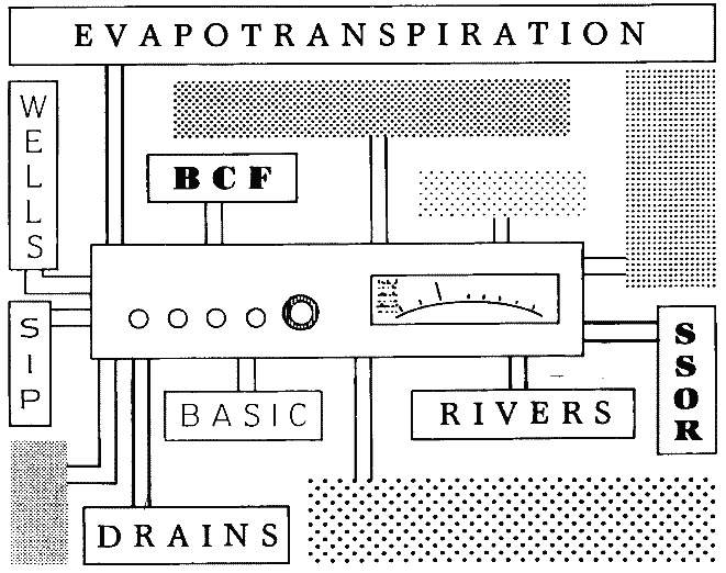
Packages
Name Long name Version introduced Required packages BAS Basic original OC Output Control original Groundwater flow packages BCF Block-Centered Flow original LPF Layer-Property Flow MODFLOW-2000 (1.0) HUF Hydrogeologic Unit Flow MODFLOW-2000 (1.1) HFB Horizontal Flow Barrier MODFLOW-88 UZF Unsaturated-Zone Flow MODFLOW-2005 (1.2) Solvers DE4 Direct Solver MODFLOW-88 (2.5) GMG Geometric Multigrid Solver MODFLOW-2000 (1.15.00) LMG Link-AMG MODFLOW-2000 (1.4) [Note 1] PCG Preconditioned Conjugate-Gradient MODFLOW-88 SIP Strongly Implicit Procedure original SOR Slice Successive Over-Relaxation original Head-dependent flux boundary packages DAF DAFLOW MODFLOW-2000 (1.11) DRN Drain original DRT Drain Return MODFLOW-2000 (1.1) ETS Evapotranspiration Segments MODFLOW-2000 (1.1) EVT Evapotranspiration original GHB General-Head Boundary original LAK Lake MODFLOW-2000 (1.1) MNW Multi-Node, Drawdown-Limited Well MODFLOW-2000 (1.11) RES Reservoir MODFLOW-88 (2.6) RIV River original SFR Streamflow-Routing MODFLOW-2000 (1.14.00) STR Stream MODFLOW-88 Other stress packages WEL Well original CHD Constant-Head Boundary MODFLOW-88 FHB Flow and Head Boundary MODFLOW-96 (3.2) RCH Recharge original Miscellaneous packages DIS Discretization MODFLOW-2000 (1.0) GAG Gage MODFLOW-2000 HYD HYDMOD MODFLOW-2000 (1.1) IBS Interbed-Storage MODFLOW-88 KDEP Hydraulic-Conductivity Depth-Dependence Capability MODFLOW-2000 (1.12) LMT Link-MT3DMS MODFLOW-2000 (1.5) LVDA Model-Layer Variable-Direction Horizontal Anisotropy Capability MODFLOW-2000 (1.12) SUB Subsidence and Aquifer-System Compaction MODFLOW-2000 (1.12) SWT Subsidence and Aquifer-System Compaction Package for Water-Table Aquifers MODFLOW-2000 (1.18) UTL Utility original Observation process input files OBS Input File For All Observations MODFLOW-2000 HOB Head-Observation MODFLOW-2000 DROB Drain Observation MODFLOW-2000 DTOB Drain Return Observation MODFLOW-2000 RVOB River Observation MODFLOW-2000 GBOB General-Head-Boundary Observation MODFLOW-2000 CHOB Constant-Head Flow Observation MODFLOW-2000 ADV Advective-Transport Observation MODFLOW-2000 (1.0) STOB Stream Observation MODFLOW-2000 Obsolete packages GFD General Finite-Difference MODFLOW-88 to 96 TLK Transient Leakage MODFLOW-88 to 96 - ^ Due to licensing restrictions, the USGS is no longer able to publicly distribute the Algebraic Multi-Grid
Graphical user interfaces
There are several graphical interfaces to MODFLOW, which often include the compiled MODFLOW code with modifications. These programs aid the input of data for creating MODFLOW models.
Non-commercial interfaces
Non-commercial MODFLOW versions are free, however, their licensing usually limit the use to non-profit educational or research purposes.
- MODFLOW-GUI – Made by the USGS: it is updated often to match the current USGS MODFLOW development. It supports MODFLOW-96, MODFLOW-2000, MODFLOW-2005, MODPATH, ZONEBUDGET, GWT, MT3DMS, SEAWAT, and GWM. Source code for MODFLOW-GUI is included. It depends on Argus ONE: a commercial interface for constructing generic models. There are no license restrictions beyond those of Argus ONE.
- PMWIN – "Processing MODFLOW" (for Windows) – powerful freeware for MODFLOW processing and visualization, provided alongside an instructional book;[9] also available in Traditional Chinese. The license for this version is limited to non-commercial use.
- ModelMuse is a grid-independent graphical user interface from the USGS for MODFLOW-2005, MODPATH, and PHAST. There are no license restrictions. The source code is included. ModelMuse
Commercial programs

Commercial MODFLOW programs are typically used by governments and consultants for practical applications of MODFLOW to real-world groundwater problems. Professional versions of MODFLOW are generally priced at a minimum of around $1000 and typically range upward to $7000 USD. This is a list of commercial programs for MODFLOW:
- GMS – Groundwater Modeling System
- Groundwater Vistas
- Processing Modflow
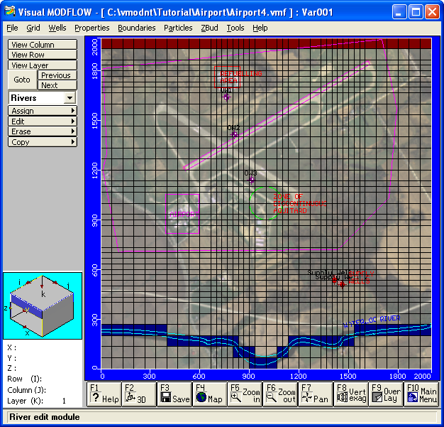
- Visual MODFLOW
All current versions of these programs run only on Microsoft Windows, however previous versions of GMS (up to Version 3.1) were compiled for several Unix platforms.
Former graphical interfaces
- Graphic Groundwater – Windows-based interface
- ModelCad – A Windows-based interface, developed by Geraghty and Miller, Inc.
- ModIME – A DOS-based interface by S.S. Papadopulos & Associates, Inc.
Other Commonly Used Groundwater Models
References
- ^ a b McDonald M.G. and Harbaugh, A.W. (2003). "The History of MODFLOW". Ground Water 41 (2): 280–283. doi:10.1111/j.1745-6584.2003.tb02591.x. PMID 12656294.
- ^ a b c McDonald, M.G., and Harbaugh, A.W. (December 28, 1983). A modular three-dimensional finite-difference ground-water flow model. Open-File Report 83-875. U.S. Geological Survey. http://pubs.er.usgs.gov/usgspubs/ofr/ofr83875.
- ^ McDonald, M.G., and Harbaugh, A.W. (1988) (PDF). A modular three-dimensional finite-difference ground-water flow model. Techniques of Water-Resources Investigations, Book 6. U.S. Geological Survey. http://pubs.usgs.gov/twri/twri6a1/.
- ^ Harbaugh, A.W., and McDonald, M.G. (1996a). User's documentation for MODFLOW-96, an update to the U.S. Geological Survey modular finite-difference ground-water flow model. Open-File Report 96-485. U.S. Geological Survey. http://water.usgs.gov/software/code/ground_water/modflow/doc/ofr96485.pdf.
- ^ Harbaugh, A.W., and McDonald, M.G. (1996). Programmer's documentation for MODFLOW-96, an update to the U.S. Geological Survey modular finite-difference ground-water flow model. Open-File Report 96-486. U.S. Geological Survey. http://water.usgs.gov/software/code/ground_water/modflow/doc/ofr96486.pdf.
- ^ Harbaugh, A.W., Banta, E.R., Hill, M.C., and McDonald, M.G. (2000). MODFLOW-2000, the U.S. Geological Survey modular ground-water model — User guide to modularization concepts and the Ground-Water Flow Process. Open-File Report 00-92. U.S. Geological Survey. http://water.usgs.gov/nrp/gwsoftware/modflow2000/ofr00-92.pdf.
- ^ Harbaugh, Arlen W. (2005). MODFLOW-2005, The U.S. Geological Survey Modular Ground-Water Model—the Ground-Water Flow Process. Techniques and Methods 6–A16. U.S. Geological Survey. http://pubs.usgs.gov/tm/2005/tm6A16/.
- ^ Wen-Hsing Chiang (2005). 3D-Groundwater Modeling with PMWIN (Second ed.). Springer. doi:10.1007/3-540-27592-4. ISBN 978-3-540-27590-9.
External links
Categories:- Hydrology models
- Geology software
- United States Geological Survey


![\frac{\partial}{\partial x} \left[ K_{xx} \frac{\partial h}{\partial x} \right] + \frac{\partial}{\partial y} \left[ K_{yy} \frac{\partial h}{\partial y} \right] + \frac{\partial}{\partial z} \left[ K_{zz} \frac{\partial h}{\partial z} \right] + W = S_{S} \frac{\partial h}{\partial t}](8/a6820d4f065b62a0bd9023e217fe0aa4.png)


Wikimedia Foundation. 2010.