- River Churnet
-
Churnet (Staffordshire) River 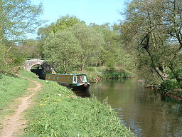 A Narrowboat has just locked down into the Churnet river at Oak Meadow Ford lock
Country England Region Staffordshire Districts The Roaches, Leek, Churnet Valley Source - location The Roaches,, Staffordshire Moorlands, Staffordshire, England - elevation 460 m (1,509 ft) Mouth - location Near Combridge, East Staffordshire, England The River Churnet is a river that flows in Staffordshire, England. It is a tributary of the River Dove.
Contents
Etymology
The origins of the name "Churnet" are unknown, though it is thought to derive from the pre-English, British name for the river.[1]
Course
The source of the river is located over 1,000 feet (300 m) above sea level in the Staffordshire moorlands, near to the Gritstone escarpment of the Roaches, and next to the A53 Leek to Buxton road and only a few hundred yards away from Black Brook which ultimately, through the Dane and Weaver, flows into the Irish Sea; however the Churnet, through the Dove, Trent and Humber Estuary ultimately flows into the North Sea.
After flowing downhill for a few miles it reaches Tittesworth reservoir, a major supplier of fresh water to the Potteries and Leek.[2] After it leaves the dam at Tittesworth, it flows into the ancient market town of Leek, where it was used until quite recently[when?] to aid the manufacture of dyes that were used in the town's textile and silk industries.[3] South of Cheddleton, the river flows through the Churnet Valley, an area of outstanding beauty with ancient woodland, an abundance of wildlife and industrial heritage.
The Caldon Canal locks into the river at Oak Meadow Ford Lock, 2 miles on from Cheddleton and river and canal are one until Consall Forge, where the canal goes its own way again. The River continues through the valley, past ancient woodland and the Bolton Copper works at Froghall, then through the villages of Oakamoor and Alton. It flows past the JCB factory at Rocester and shortly after it joins the River Dove near the hamlet of Combridge.
The Churnet Valley
The course of the River from Cheddleton to Rocester runs through the Churnet Valley - a part of Staffordshire that has been known as Staffordshire's Rhineland.[4] Throughout the valley there are steep gorges and banks, with an abundance of woodland and Wildlife. There are several woods owned by the National Trust and the RSPB.
Industry
The Churnet has been heavily influenced by industry along its length for nearly a thousand years and as a result became possibly the most polluted river in Europe.[5] The river was heavily used in Leek by the textile industry to make dyes. The dyeing industry was established in 1734 and it was claimed that the water from the Churnet was the finest in Europe for this purpose.[6] In nearby Cheddleton the Churnet was used to power a flint mill that ground down flint for use in the pottery industry. Further downriver at Froghall and at Oakamoor the Thomas Bolton Copper works used the power of the Churnet to help manufacture the world's first transatlantic telegraph cables.[7] The processes involved in manufacturing copper wire at the sites caused high levels of pollution.
The Churnet Valley was heavily involved in the iron smelting industry and it is documented from as long ago as 1290 that iron was smelted using the river as its main source of energy.[8] The early forges were at East Wall,near to Oakamoor but a later forge is still standing at Consall, next to the locks on the Caldon Canal.
The Caldon Canal runs with the river through the Churnet Valley and along parts the river is canalised. There was intensive freight traffic on the waterway transporting limestone and ironstone from the wharves on the canal.
Today the only industrial use of the river is by the sand quarry at Oakamoor.
Since the decline of industry in Leek and the Churnet Valley, the quality of the water has improved so much that a programme of re-introducing Salmon is underway.[9]
References
- ^ [1] The Staffordshire Encyclopedia,retrieval date:31-01-08
- ^ Severn Trent Water, Tittesworth Water facts and figures retrieval date:01-02-09
- ^ Exploring The Potteries Industrial Sites, Textiles in Leek retrieval date:30-01-09
- ^ Staffordshire County Council,The Staffordshire Way retrieval date:02-02-09
- ^ BBC News, Salmon re-introduced to the River Churnet
- ^ D G Stewart, M W Greenslade (1965(1st Edition). A History Of Staffordshire. Phillimore & Co Ltd. ISBN 1 86077 071 1.
- ^ Peak Experience,A Guide to The Peak District retrieval date:02-02-09
- ^ Chester, Herbert (2002(2nd Edition)). Churnet Valley Iron, The Mills and The Mines. Landmark Publishing Ltd. ISBN 1 84306 011 6.
- ^ BBC News, Salmon re-introduced to the River Churnet
Coordinates: 52°56′N 1°51′W / 52.933°N 1.85°W
External links
Categories:- Rivers of Staffordshire
- Rivers and valleys of the Peak District
- Staffordshire Moorlands

Wikimedia Foundation. 2010.